| During the month of April, Mark Miller will donate $75 to the charity of your choice (5 to chose from, including the Utah Avalanche Center!) Mark Miller Subaru has raised over $300k in the previous 6 Do Good Feel Good events. More Info here |  |
| During the month of April, Mark Miller will donate $75 to the charity of your choice (5 to chose from, including the Utah Avalanche Center!) Mark Miller Subaru has raised over $300k in the previous 6 Do Good Feel Good events. More Info here | |
| Advisory: Skyline Area Mountains | Issued by Craig Gordon for Sunday - December 21, 2014 - 6:29am |
|---|

|
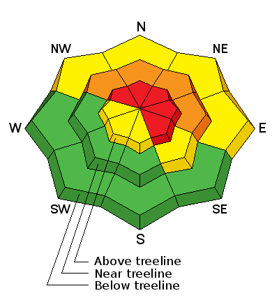
bottom line It will be a day of rising avalanche danger In the wind zone at and above treeline the avalanche danger will rise to HIGH as the day progresses and storm gets under way. Both human triggered and natural avalanches are likely especially on steep, wind drifted slopes. A CONSIDERABLE danger is found on mid elevation, wind drifted slopes and human triggered avalanches are probable. Looking for LOW avalanche danger? Let the snow stack up a bit and head to low elevation south facing slopes that have no preexisting weak snow issues.
|
 |
avalanche warning THIS AVALANCHE WARNING IS FOR THE WASATCH...BEAR RIVER AND WESTERN UINTA MOUNTAIN RANGES...THE WASATCH PLATEAU AND THE CENTRAL UTAH MOUNTAINS. A WARM WINTER STORM WITH HEAVY SNOW AND STRONG WINDS WILL MAKE AVALANCHE CONDITIONS INCREASINGLY DANGEROUS THROUGH MONDAY. HUMAN TRIGGERED AND NATURAL AVALANCHES WILL BE LIKELY TODAY THROUGH MONDAY ON STEEP TERRAIN ABOVE 8000 FEET. RAIN BELOW 8000 FEET MAY PRODUCE UNSTABLE AVALANCHE CONDITIONS AT LOWER ELEVATIONS AS WELL. PEOPLE SHOULD AVOID BEING ON OR BELOW ANY STEEP SNOW COVERED SLOPES UNTIL AVALANCHE CONDITIONS IMPROVE. |
 |
special announcement
Huge thanks to Sam T Evans and Look Trailers for generously donating a loaner two place sled trailer for the 2014-15 season.... y'all rock! We just released an exciting, new avy safety video designed specifically for snowmobilers - Knowledge is Powder. https://vimeo.com/113677686 NEW THIS YEAR: You can now receive advisories by email for each region in the state. Go here for details.
|
 |
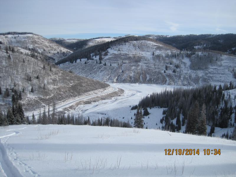
current conditions The storm is at our doorstep and light snow is beginning to fall. Temperatures are in the upper 20's and low 30's and southwest winds began ramping up early this morning, gusting into the mid 20's along the summit. With average snow depths only in the 18" range, it's still relatively shallow on the Skyline.
Until we get more snow, low angle, rock free meadows and road rides are your best bet right now. |
 |
recent activity No avalanche activity to report.
|
| type | aspect/elevation | characteristics |
|---|

|
|
LIKELIHOOD
 LIKELY
UNLIKELY
SIZE
 LARGE
SMALL
TREND
 INCREASING DANGER
SAME
DECREASING DANGER
|
|
description
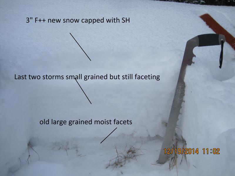
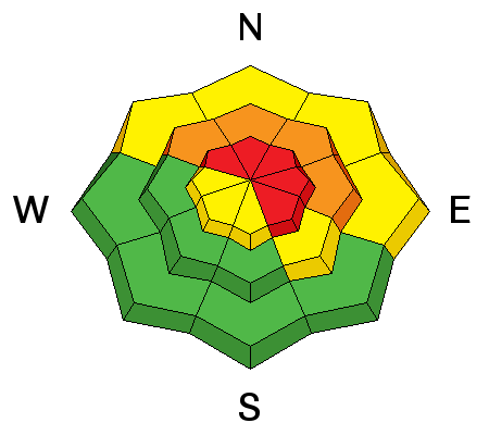
We've been treated to relatively benign avalanche conditions this season... that's all about to come to a screeching halt. The big weekend storm is definitely gonna be a game changer. Heavy snow, strong winds, and rising temperatures will add up to dangerous avalanche conditions in the backcountry. As the storm develops and winds begin to ramp up, the avalanche danger will rise rather quickly. This mornings shallow drifts will become this afternoons unmanageable avalanche and slides will begin breaking deeper and wider than you might expect. In addition, today's avalanches can be triggered from a distance and on relatively low angle terrain. Once initiated, they're gonna be packing a punch and can easily ruin your day. It doesn't mean you can't ride.... it does mean you're gonna have to be on your A Game today. Look for and avoid any steep wind drifted slope, especially if the snow looks fat and rounded or sounds hollow like a drum.
The weak and sugary surface snow will be no match for the dense, heavy snow and strong winds expected tonight and tomorrow. Steve, Darce, and Cody were out stomping around Friday and their great insight on the conditions can be found here. |
| type | aspect/elevation | characteristics |
|---|

|
|
LIKELIHOOD
LIKELY
UNLIKELY
SIZE
LARGE
SMALL
TREND
INCREASING DANGER
SAME
DECREASING DANGER
|
|
description
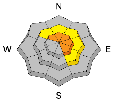
While not widespread, any avalanche triggered today has the potential to break into weak layers buried deeper in the snowpack. Of course, that would result in a large and dangerous avalanche. Our usual problem child, steep, rocky slopes with a weak shallow snowpack would be likely suspect terrain. |
 |
weather The strong, moist northwest flow has arrived and will persist into tonight with rising snow levels. Today we can expect heavy snow, west and northwest winds gusting to 50 mph along the ridges, and temperatures rising into the mid 30's. A cold front crosses northern Utah late tonight. Snow levels will fall again and snow will turn showery Monday and gradually taper off. Very strong winds will develop over the ridges today and nuke through Monday.
|
| general announcements We're still interested in snow and avalanche information. If you see anything we should know about, please participate in the creation of our own community avalanche advisory by submitting snow and avalanche conditions. You can call me directly at 801-231-2170, email [email protected], or email by clicking HERE Donate to your favorite non-profit –The Utah Avalanche Center. The UAC depends on contributions from users like you to support our work. Benefit the Utah Avalanche Center when you buy or sell on ebay - set the Utah Avalanche Center as a favorite non-profit in your ebay account here and click on ebay gives when you buy or sell. You can choose to have your seller fees donated to the UAC, which doesn't cost you a penny. Utah Avalanche Center mobile app - Get your advisory on your iPhone along with great navigation and rescue tools. The information in this advisory is from the US Forest Service which is solely responsible for its content. This advisory describes general avalanche conditions and local variations always occur. I will update this advisory by 7:00 AM Monday Dec. 22, 2014. |


.jpg)