| During the month of April, Mark Miller will donate $75 to the charity of your choice (5 to chose from, including the Utah Avalanche Center!) Mark Miller Subaru has raised over $300k in the previous 6 Do Good Feel Good events. More Info here |  |
| During the month of April, Mark Miller will donate $75 to the charity of your choice (5 to chose from, including the Utah Avalanche Center!) Mark Miller Subaru has raised over $300k in the previous 6 Do Good Feel Good events. More Info here | |
| Advisory: Skyline Area Mountains | Issued by Craig Gordon for Saturday - March 29, 2014 - 5:56am |
|---|


|
bottom line Overall, the avalanche danger is MODERATE this weekend and human triggered avalanches are possible on steep, wind drifted slopes. While not widespread, avalanches still have the possibility to break deep and wide, especially on steep, rocky, upper elevation terrain facing the north half of the compass. As the sun bakes the snow surface, the danger of wet avalanches will rise to MODERATE. Human triggered avalanches are possible on steep, sunny slopes with daytime heating.
|
 |
special announcement This weekend will be the last of our regularly scheduled advisories for the 2013-14 season. |
 |
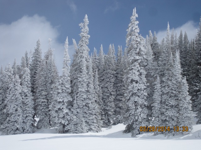
current conditions It’ll be a beautiful day on the Skyline as high pressure briefly visits the region. Looks like weather will cooperate for this years shootout. Under partly cloudy skies, temperatures are in the mid 20's and west-southwest winds are blowing 5-15 mph along the summit. Thursday’s storm delivered 10” of medium density snow and the riding is about as good as it gets with a solid, supportable, go anywhere base.
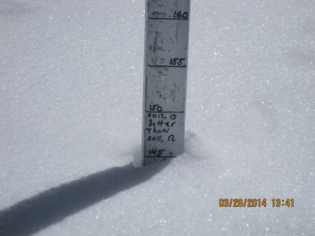
The Skyline is white!Steve's snowstake at Miller Flat clearly shows it's been a good spring on the Skyline! Darce and Steve avoided the crowds and were in Electric Lake yesterday. Their trip report can be found here.
|
 |
recent activity No new avalanche activity to report.
|
| type | aspect/elevation | characteristics |
|---|

|

|
LIKELIHOOD
 LIKELY
UNLIKELY
SIZE
 LARGE
SMALL
TREND
 INCREASING DANGER
SAME
DECREASING DANGER
|
|
description
Winds cranked along the high peaks all day Thursday, lingering into the early portion of Friday morning. Gusting into the 40's and 50's, west and northwest winds found plenty of snow to blow around, easily forming fresh drifts sensitive to the additional weight of a rider. Surprisingly, soft slabs formed not only on the leeward side of ridges, but also lower down slope than you might expect and around terrain features like chutes and gullies. While generally manageable in size and depth and predictably breaking within the new storm snow, remember that if you’re getting into steep, sustained, technical terrain even a small slide could knock you off your feet or sled and take you for a nasty ride through trees or over a cliff band. Slope cuts on small test slopes like road cuts will give you a good barometer for the kind of avalanche dragon you're dealing with. Get some solid BETA by tweaking small slopes before charging into big terrain today.
Lots of wind loading. Not only on the leeward side of ridges near the summit, but also around terrain features like chutes and gullies. |
| type | aspect/elevation | characteristics |
|---|

|

|
LIKELIHOOD
LIKELY
UNLIKELY
SIZE
LARGE
SMALL
TREND
 INCREASING DANGER
SAME
DECREASING DANGER
|
|
description
The sun is high in the sky and it's intense this time of year, rapidly heating the snow surface. Make sure you have an exit strategy planned when slopes become wet during the heat of the day. Avoid being below steep slopes and in confined terrain such as gullies where wet, cement-like snow can pile up very deeply.. |
 |
weather Warm and windy today ahead of the next storm. Look for thickening clouds, temperatures rising into the low 40's, and southwest winds cranking into the 50's and 60's by about dinner time. A cold front is forecast to arrive Sunday morning and we'll see widespread snow showers with 8"-10" of snow stacking up by late in the day. A break in the action for early Monday, and then snow redevelops late Monday ahead of a storm system expected to dominate the region through mid week. |
| general announcements Donate to your favorite non-profit –The Utah Avalanche Center. The UAC depends on contributions from users like you to support our work. Benefit the Utah Avalanche Center when you buy or sell on ebay - set the Utah Avalanche Center as a favorite non-profit in your ebay account here and click on ebay gives when you buy or sell. You can choose to have your seller fees donated to the UAC, which doesn't cost you a penny. Utah Avalanche Center mobile app - Get your advisory on your iPhone along with great navigation and rescue tools. The information in this advisory is from the US Forest Service which is solely responsible for its content. This advisory describes general avalanche conditions and local variations always occur. This advisory will be updated on Monday, March 31, 2014 with general avalanche information for springtime riding. |


.jpg)