
| During the month of April, Mark Miller will donate $75 to the charity of your choice (5 to chose from, including the Utah Avalanche Center!) Mark Miller Subaru has raised over $300k in the previous 6 Do Good Feel Good events. More Info here |  |
| During the month of April, Mark Miller will donate $75 to the charity of your choice (5 to chose from, including the Utah Avalanche Center!) Mark Miller Subaru has raised over $300k in the previous 6 Do Good Feel Good events. More Info here | |
| Advisory: Skyline Area Mountains | Issued by Craig Gordon for Saturday - March 1, 2014 - 6:16am |
|---|


|
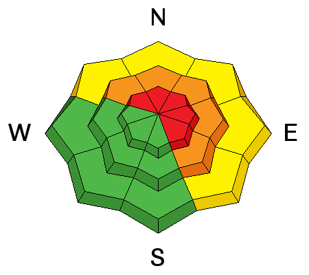
bottom line A HIGH avalanche danger exists today in the wind zone along the summit. Human triggered avalanches are likely on steep, leeward slopes, especially those facing the north half of the compass. Mid elevation terrain offers CONSIDERABLE avalanche danger and human triggered avalanches are probable on steep wind drifted slopes. Fresh drifts have formed in low elevation terrain as well and a MODERATE danger exists. Human triggered avalanches are possible on steep slopes with recent deposits of wind drifted snow. Looking for LOW avalanche danger? Head to low angle wind sheltered terrain with no steep slopes above or adjacent to where you're riding.
|
 |
avalanche warning THIS AVALANCHE WARNING IS FOR THE MOUNTAINS OF NORTHERN AND CENTRAL UTAH. HEAVY SNOW AND HIGH WIND HAVE CREATED A HIGH AVALANCHE DANGER. BACKCOUNTRY TRAVELERS SHOULD STAY ON SLOPES LESS THAN 30 DEGREES AND AVOID AVALANCHE RUN OUT AREAS. THIS WARNING DOES NOT INCLUDE SKI AREAS OR HIGHWAYS WHERE AVALANCHE CONTROL IS NORMALLY DONE. |
 |
current conditions Southwest winds are making headlines this morning. After a brief break early this morning, they're starting to nuke along the ridges with hourly averages in the 30's and 40's, gusting to 50 mph along the high peaks. The region has received about a foot of dense snow since late Thursday. Currently, temperatures are in the mid 20's and low 30's. Riding and turning conditions are quite good on wind sheltered, shady slopes.
Even though we're about a month behind, the Skyline is filling in nicely. There's 130 cm total snow at Miller Flat Trailhead. |
 |
recent activity Here is the avalanche list that hardly covers a sliver of the terrain that avalanched over the last few weeks:
|
| type | aspect/elevation | characteristics |
|---|

|

|
LIKELIHOOD
 LIKELY
UNLIKELY
SIZE
 LARGE
SMALL
TREND
 INCREASING DANGER
SAME
DECREASING DANGER
|
|
description
Seems like nearly every slope on the Skyline avalanched in the big February cycle, but those that didn't still have the potential to break to weak snow near the ground. While many slopes are thick and strong, the snow structure remains questionable, especially in steep, rocky terrain facing the north half of the compass. Problem is... the surface snow feels strong and solid underneath us, but it's the bad mojo near the ground that's the big red flag. Strong snow over weak snow often suggests false green light conditions, allowing us to get well out onto the slope or put several sets of tracks on the hill before we find a weakness, collapse the slope, and now all bets are off. Once triggered, avalanches can break deep and wide, taking out the entire seasons snowpack. Best way to manage this situation is with terrain choices. Simply tone down your objectives the next few days and avoid being on or under steep leeward slopes. Slopes facing the south half of the compass and terrain that already avalanched big in February offer more predictable avalanche conditions.
|
| type | aspect/elevation | characteristics |
|---|

|
|
LIKELIHOOD
 LIKELY
UNLIKELY
SIZE
 LARGE
SMALL
TREND
INCREASING DANGER
SAME
DECREASING DANGER
|
|
description
Wind drifts may break deeper and wider than you might expect. They're packing a hefty punch and will quickly ruin your day, especially if you get slammed into trees or knocked over a cliff. In addition, once triggered, today's drifts have the possibility to break into weaker layers of snow, buried deeper in the snowpack. In either case, a seemingly benign situation can get quickly out of hand. As always, look for and avoid any fat, rounded pillow of snow, especially if it sounds hollow like a drum. |
 |
weather Southwest winds are expected to increase this morning and should be gusting into the 50's and 60's, before diminishing late in the day. Temperatures remain mild and don't vary much from where we're at this morning, dipping into the low 20's overnight. Snow showers continue throughout the day with an additional 3"-6" possible before tapering off late tonight. Scattered snow showers are on tap for Sunday and then high pressure begins to build for early next week. |
| general announcements Donate to your favorite non-profit –The Utah Avalanche Center. The UAC depends on contributions from users like you to support our work. Benefit the Utah Avalanche Center when you buy or sell on ebay - set the Utah Avalanche Center as a favorite non-profit in your ebay account here and click on ebay gives when you buy or sell. You can choose to have your seller fees donated to the UAC, which doesn't cost you a penny. Utah Avalanche Center mobile app - Get your advisory on your iPhone along with great navigation and rescue tools. The information in this advisory is from the US Forest Service which is solely responsible for its content. This advisory describes general avalanche conditions and local variations always occur. This advisory will be updated by 7:00 AM Saturday, March 8th, 2014 or sooner if conditions warrant. |


.jpg)


