| During the month of April, Mark Miller will donate $75 to the charity of your choice (5 to chose from, including the Utah Avalanche Center!) Mark Miller Subaru has raised over $300k in the previous 6 Do Good Feel Good events. More Info here |  |
| During the month of April, Mark Miller will donate $75 to the charity of your choice (5 to chose from, including the Utah Avalanche Center!) Mark Miller Subaru has raised over $300k in the previous 6 Do Good Feel Good events. More Info here | |
| Advisory: Skyline Area Mountains | Issued by Craig Gordon for Monday - February 17, 2014 - 6:29am |
|---|

|
bottom line Avalanche conditions are sketchy. In the past week, there's been an avalanche fatality and several close class. Please tone it down today and think about the consequences of triggering an unmanageably deep avalanche and the possibility of not coming home to your family. The avalanche danger remains HIGH. Deep, dangerous, and possibly unsurvivable human triggered avalanches are likely. It is crucial to avoid all steep. mid and upper elevation wind drifted slopes, and consider the consequences of triggering an avalanche that breaks to the ground.
|
 |
avalanche warning THIS AVALANCHE WARNING IS FOR THE MOUNTAINS OF NORTHERN AND CENTRAL UTAH. A HIGH AVALANCHE DANGER CONTINUES WITH LARGE, NATURAL AND HUMAN TRIGGERED AVALANCHES POSSIBLE. BACKCOUNTRY TRAVELERS SHOULD AVOID SLOPES STEEPER THAN 30 DEGREES AND AVALANCHE RUNNOUT AREAS. THIS WARNING DOES NOT INCLUDE SKI AREAS OR HIGHWAYS WHERE AVALANCHE CONTROL IS NORMALLY DONE. |
 |
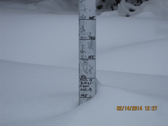
current conditions Skies cleared last night and temperatures fell into the mid 20's. Southwest winds blew into the 30's for most of Sunday, but have mellowed somewhat and are currently blowing 10-20 mph along the high peaks. Riding and turning conditions are quite good, especially in mid and upper elevation wind sheltered terrain. Recent trip reports can be found here.
The region got pasted last week and the Skyline is white. |
 |
recent activity
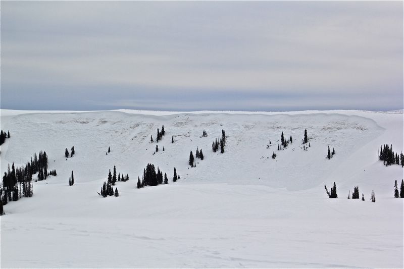
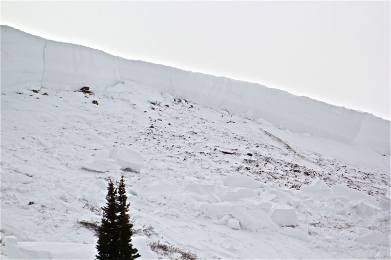
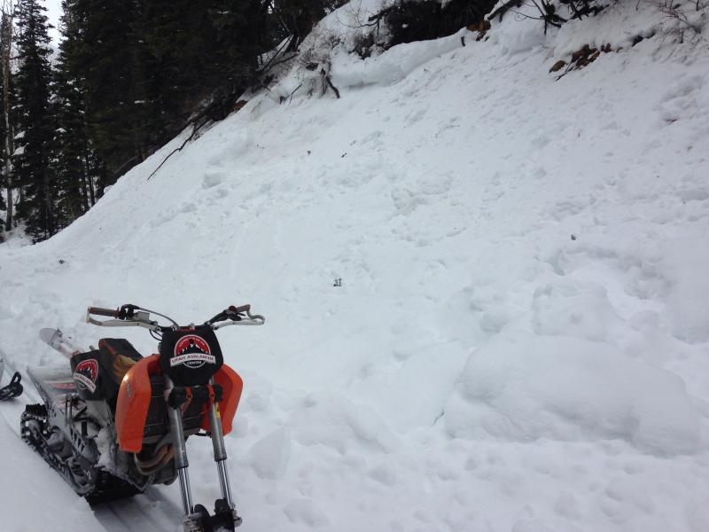
From Cade Beck and Brett who visited the site of this masssive sled triggered slide in Spring Creek yesterday... "rider was hill climbing in the looker right half of the bowl. At apex of highmark the slope released. He was able to ride the avalanche on his sled most of the way down before getting bucked off and thrown near the toe. Luckily, he was not buried or seriously injured." More details here. Even more recent avalanche activity can be found here.
|
| type | aspect/elevation | characteristics |
|---|

|

|
LIKELIHOOD
 LIKELY
UNLIKELY
SIZE
 LARGE
SMALL
TREND
 INCREASING DANGER
SAME
DECREASING DANGER
|
|
description
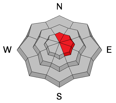
Nothing has changed since yesterday and we've got it all.... weak snowpack structure, lots of water and snow from the recent storm cycle, and the biggest red flag.... lots of deep, scary avalanches! It's a dangerous setup on the Skyline because the snow will feel strong and stable under our sled, skis, or board. However, we've gotta think not only about the snow we're riding in, but also the snow we're riding on, and it's a sketchy setup. Early season snow grew weak and sugary over time and now we have a cohesive piece of snow resting on top. Strong snow on weak snow.... no es bueno!. The snowpack needs some time to heal and we need to exercise some patience. For the next couple of days you need to avoid being on or under steep slopes, especially those that face the north half of the compass. Click here for a quick viddy describing the setup. |
| type | aspect/elevation | characteristics |
|---|

|

|
LIKELIHOOD
LIKELY
UNLIKELY
SIZE
 LARGE
SMALL
TREND
 INCREASING DANGER
SAME
DECREASING DANGER
|
|
description
Road lappers please take note- Rapidly warming temperatures could increase the possibility of wet avalanches and it doesn't take a large slide to stack up deep piles of cement-like snow, especially if it's channeled into a terrain trap like a gully or stream bed. Just 'cause you can see the car doesn't mean it's safe. Carefully assess your terrain choices and think about the consequences of triggering even a small slide.
Even a small wet avalanche can pile up a ton of bone snapping snow like seen here on this road cut. |
| type | aspect/elevation | characteristics |
|---|

|
|
LIKELIHOOD
LIKELY
UNLIKELY
SIZE
LARGE
SMALL
TREND
INCREASING DANGER
SAME
DECREASING DANGER
|
|
description
Strong west and southwest winds have made cornices quite large and they're unpredictable, breaking back further than you might expect. Once triggered, a cornice could easily break into weaker layers of snow as it crashes to the slope below, creating a slide that quickly gets out of hand.. |
 |
weather Sunny skies with increasing winds and high clouds late in the day. Temperatures climb into the upper 30's before dipping into the low 20's overnight. Cooler for Tuesday and then more storminess is slated for Wednesday and Friday. |
| general announcements Donate to your favorite non-profit –The Utah Avalanche Center. The UAC depends on contributions from users like you to support our work. Benefit the Utah Avalanche Center when you buy or sell on ebay - set the Utah Avalanche Center as a favorite non-profit in your ebay account here and click on ebay gives when you buy or sell. You can choose to have your seller fees donated to the UAC, which doesn't cost you a penny. Utah Avalanche Center mobile app - Get your advisory on your iPhone along with great navigation and rescue tools. The information in this advisory is from the US Forest Service which is solely responsible for its content. This advisory describes general avalanche conditions and local variations always occur. This advisory will be updated by 7:00 AM Saturday, February 22nd, 2014 or sooner if conditions warrant. |


.jpg)