| During the month of April, Mark Miller will donate $75 to the charity of your choice (5 to chose from, including the Utah Avalanche Center!) Mark Miller Subaru has raised over $300k in the previous 6 Do Good Feel Good events. More Info here |  |
| During the month of April, Mark Miller will donate $75 to the charity of your choice (5 to chose from, including the Utah Avalanche Center!) Mark Miller Subaru has raised over $300k in the previous 6 Do Good Feel Good events. More Info here | |
| Advisory: Skyline Area Mountains | Issued by Craig Gordon for Friday - February 14, 2014 - 5:40am |
|---|


|
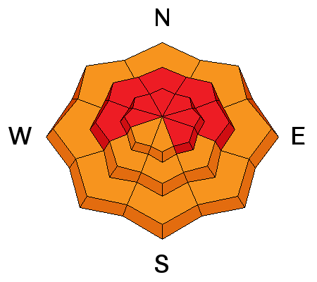
bottom line The avalanche danger remains HIGH. Deep, dangerous, and possibly unsurvivable human triggered avalanches are likely. It is crucial to tone it down, avoid all steep slopes, and consider the consequences of triggering an avalanche that breaks to the ground, taking out the entire seasons snowpack.
|
 |
avalanche warning AN AVALANCHE WARNING CONTINUES FOR THE MANTI-SKYLINE WHERE VERY DANGEROUS AVALANCHE CONDITIONS EXIST. DEEP, DANGEROUS AVALANCHES CAN BE TRIGGERED FROM A DISTANCE AND LOW ON THE SLOPE. TODAY YOU NEED TO STAY OFF OF AND OUT FROM UNDER STEEP WIND DRIFTED TERRAIN.
|
 |
special announcement Our collective prayers, thoughts, and condolences go out to the friends and family of Clinton Conover who was tragically killed in an avalanche accident on Sunday. Our preliminary investigation is found here. |
 |
current conditions Warm, wet, and windy. An inch or two of very dense snow fell yesterday and temperatures are in the low to mid 30's. Southwest winds blew in the 20's and 30's Wednesday and Thursday, diminishing late yesterday and are currently blowing 5-15 mph along the high ridges. Recent trip reports can be found here.
|
 |
recent activity
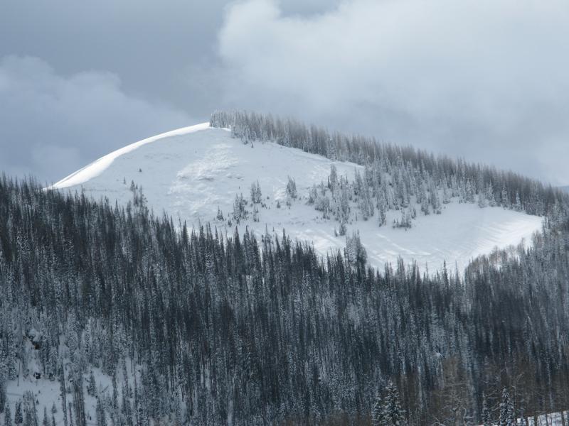
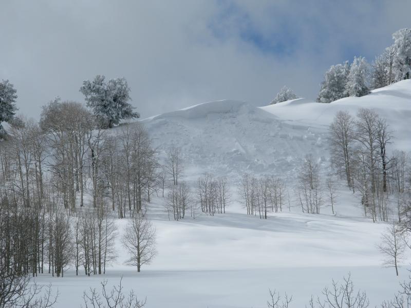
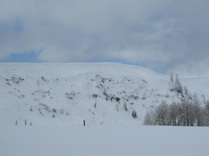
Avalanches everywhere. All aspects, elevations, and unusual locations... along with a crazy tale from the Skyline Mine.
|
| type | aspect/elevation | characteristics |
|---|

|
|
LIKELIHOOD
 LIKELY
UNLIKELY
SIZE
 LARGE
SMALL
TREND
 INCREASING DANGER
SAME
DECREASING DANGER
|
|
description
Avalanche danger remains HIGH on the Manti-Skyline and the elevated danger isn't going to magically disappear. The setup is dangerous because early season snow grew weak and sugary over time and now we have a cohesive piece of snow resting on top.... strong snow on weak snow. The snowpack needs some time to heal and we need to exercise some patience. For the next couple of days you need to avoid being on or under steep slopes, especially those that face the north half of the compass. Click here for a quick viddy describing the setup. |
 |
weather The Skyline might be a little too far south to see much accumulating snow today, but mostly cloudy skies and warm temperatures are a pretty good bet. West and southwest winds blow in the 20's and 30's along the high ridges and temperatures warm into the low 40's before dipping to near freezing overnight. A break in the action is expected Saturday and temperatures warm considerably, before a fast moving cold front brings additional snow Sunday. |
| general announcements Donate to your favorite non-profit –The Utah Avalanche Center. The UAC depends on contributions from users like you to support our work. Benefit the Utah Avalanche Center when you buy or sell on ebay - set the Utah Avalanche Center as a favorite non-profit in your ebay account here and click on ebay gives when you buy or sell. You can choose to have your seller fees donated to the UAC, which doesn't cost you a penny. Utah Avalanche Center mobile app - Get your advisory on your iPhone along with great navigation and rescue tools. The information in this advisory is from the US Forest Service which is solely responsible for its content. This advisory describes general avalanche conditions and local variations always occur. This advisory will be updated by 7:00 AM Saturday, February 15th, 2014. |


.jpg)