
| During the month of April, Mark Miller will donate $75 to the charity of your choice (5 to chose from, including the Utah Avalanche Center!) Mark Miller Subaru has raised over $300k in the previous 6 Do Good Feel Good events. More Info here |  |
| During the month of April, Mark Miller will donate $75 to the charity of your choice (5 to chose from, including the Utah Avalanche Center!) Mark Miller Subaru has raised over $300k in the previous 6 Do Good Feel Good events. More Info here | |
| Advisory: Skyline Area Mountains | Issued by Brett Kobernik for Friday - January 24, 2014 - 7:32pm |
|---|

|
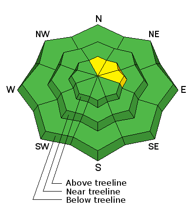
bottom line Most areas have a LOW avalanche danger and it is generally safe in the backcountry right now. A MODERATE avalanche danger exists in the upper elevation slopes approaching 40 degrees or steeper that face north through east. Human triggered slab avalanches are possible in this terrain.
|
 |
current conditions We've had very mild weather again for the last week with no significant storms. Daytime ridgetop temperatures have been around 30. The moderate speed east winds slowed and switched to the northwest. Wind crusts and sun crusts make up a good portion of the upper elevation surface conditions. Undisturbed loose snow can still be found in protected areas. The snowpack is very weak in many areas which is obvious when your track sinks through the entire pack during any little climb. |
 |
recent activity There was one avalanche reported from over the last week. It was on Wedding Ring Ridge near Highway 31 above Miller Flat. (DETAILS on new avalanche) This path also avalanched two weeks ago. (DETAILS on old avalanche) This is the type of terrain that is obviously still suspect - steep, upper elevation east facing slopes with recent deposits of wind drifted snow.
|
| type | aspect/elevation | characteristics |
|---|

|
|
LIKELIHOOD
 LIKELY
UNLIKELY
SIZE
 LARGE
SMALL
TREND
 INCREASING DANGER
SAME
DECREASING DANGER
|
|
description
As time goes on, the chance for triggering a slab avalanche that breaks into weak sugary snow decreases. It is not very likely that you will trigger an avalanche unless you are on very steep upper elevation slopes that face north through east. Areas that have been loaded by west wind should be avoided. Look for large 'pillows' of snow indicating these drifts.
|
 |
weather We will see continued mild weather through the weekend with clear skies and ridgetop high temperatures in the upper 20s or low 30s. Winds will be fairly light from the northwest. Mild weather will continue into next week. It does look like we'll see some chances for snow as a number of weather disturbances move through starting at the end of next week. They don't look like huge storms at this point but might give us some much needed snow. |
| general announcements Donate to your favorite non-profit –The Utah Avalanche Center. The UAC depends on contributions from users like you to support our work. Benefit the Utah Avalanche Center when you buy or sell on ebay - set the Utah Avalanche Center as a favorite non-profit in your ebay account here and click on ebay gives when you buy or sell. You can choose to have your seller fees donated to the UAC, which doesn't cost you a penny. Utah Avalanche Center mobile app - Get your advisory on your iPhone along with great navigation and rescue tools. The information in this advisory is from the US Forest Service which is solely responsible for its content. This advisory describes general avalanche conditions and local variations always occur. This advisory will be updated by 7:00 AM Saturday, February 1st, 2014. |


.jpg)

