| During the month of April, Mark Miller will donate $75 to the charity of your choice (5 to chose from, including the Utah Avalanche Center!) Mark Miller Subaru has raised over $300k in the previous 6 Do Good Feel Good events. More Info here |  |
| During the month of April, Mark Miller will donate $75 to the charity of your choice (5 to chose from, including the Utah Avalanche Center!) Mark Miller Subaru has raised over $300k in the previous 6 Do Good Feel Good events. More Info here | |
| Advisory: Skyline Area Mountains | Issued by Brett Kobernik for Friday - December 20, 2013 - 7:58pm |
|---|

|
bottom line The avalanche danger will be CONSIDERABLE in the upper elevation northwest through east facing slopes of 35 degrees and steeper. This means human triggered avalanches are likely. There is a MODERATE out of the wind effected terrain which means human triggered avalanches are possible. If the wind doesn't increase in speed, the avalanche danger will remain MODERATE everywhere.
|
 |
current conditions The recent storm produced 3 to 5 inches of new medium density snow as of Friday afternoon. Not much wind was involved with the storm so the snow is fairly evenly distributed. This will probably change on Saturday as the winds pick up speed. There is plenty of loose, sugary weak snow under the new snow. The new snow itself was not enough to overload the weak layers on Friday. Here are a couple of recent observations with some snow profile diagrams that point out the weak underlying snow.
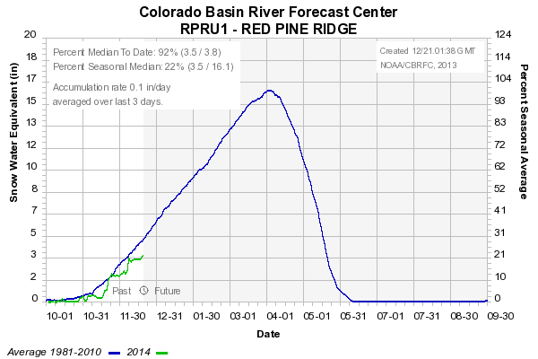
These weak layers form during extended dry periods. We've had a number of these periods this winter. While we're not off to the best start stability wise and snow depth wise, we are actually not all that far behind yet. Here are a couple of charts from the nearby Snotel sites. |
| type | aspect/elevation | characteristics |
|---|

|
|
LIKELIHOOD
 LIKELY
UNLIKELY
SIZE
 LARGE
SMALL
TREND
 INCREASING DANGER
SAME
DECREASING DANGER
|
|
description
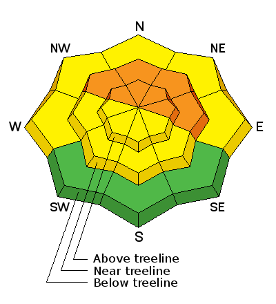
By far, the biggest danger is triggering a slab avalanche that breaks into weak, sugary faceted snow which is now under the most recent new snow. In wind sheltered areas, this is not a problem currently. However, as the winds increase on Saturday, the snow may get blown into drifts that could release as a slab avalanche. The wind will be from the northwest so it will mainly be drifting snow onto the east facing slopes. Keep in mind that there are always lots of local variations with the wind which can form drifts on slopes that face any direction. This avalanche problem will be the most pronounced in the upper elevations. It is less dangerous in the mid elevations but don't dismiss it. Human triggered avalanches may be possible in the mid elevations as well. |
| type | aspect/elevation | characteristics |
|---|

|
|
LIKELIHOOD
 LIKELY
UNLIKELY
SIZE
 LARGE
SMALL
TREND
INCREASING DANGER
SAME
DECREASING DANGER
|
|
description
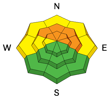
If the wind does pick up like it looks like it should, keep an eye out for fresh wind drifts on all aspects in the mid and upper elevations. In the absence of older weak sugary snow, these fresh wind drifts won't pose a great threat. |
 |
weather Another storm sliding in from the northwest should produce snow showers along with an increase in wind speeds. Northwest winds will increase as the day goes on. Ridgetop temperatures will be in the low 20s and upper teens. This storm doesn't look like it's huge but might add a few more inches of snow. We may see snow showers lingering into Sunday with continued gusty northwest winds. Things clear out on Monday. Looking at the long term, it doesn't look like the next significant chance for snow will happen until about the 28th. |
| general announcements Remember your information can save lives. Please let us and the rest of the community know what you are seeing out there by submitting snow and avalanche conditions. This is a great time of year to schedule a free avalanche awareness presentation for your group or club. Contact either Craig Gordon or Brett Kobernik by emailing us: Donate to your favorite non-profit –The Utah Avalanche Center. The UAC depends on contributions from users like you to support our work. Benefit the Utah Avalanche Center when you buy or sell on ebay - set the Utah Avalanche Center as a favorite non-profit in your ebay account here and click on ebay gives when you buy or sell. You can choose to have your seller fees donated to the UAC, which doesn't cost you a penny. Utah Avalanche Center mobile app - Get your advisory on your iPhone along with great navigation and rescue tools. The information in this advisory is from the US Forest Service which is solely responsible for its content. This advisory describes general avalanche conditions and local variations always occur. This advisory will be updated by 8:00 PM December 6th. |


.jpg)