| During the month of April, Mark Miller will donate $75 to the charity of your choice (5 to chose from, including the Utah Avalanche Center!) Mark Miller Subaru has raised over $300k in the previous 6 Do Good Feel Good events. More Info here |  |
| During the month of April, Mark Miller will donate $75 to the charity of your choice (5 to chose from, including the Utah Avalanche Center!) Mark Miller Subaru has raised over $300k in the previous 6 Do Good Feel Good events. More Info here | |
| Advisory: Skyline Area Mountains | Issued by Craig Gordon for Friday - November 29, 2013 - 8:12pm |
|---|


|
bottom line This weekend a LOW avalanche danger exists on the Skyline and human triggered avalanches are unlikely. However, LOW danger doesn't mean NO danger. Keep in mind that even small avalanches are more dangerous this time of year due to rocks, logs, and stumps just under the snow surface.
|
 |
current conditions Early season conditions exist on the Skyline with very little snow to ride on... but there is a glimmer of hope in sight midweek. Until then, average snow depths are hovering right around a foot and an early season ride on a rock free road is about all we can hope for this weekend. Darce and Steve were out and about and posted a great trip report. Click here to view.
White from far, but far from white.... the Skyline needs snow!
It's a perfect time to practice your beacon skills near the Big Drift parking lot.
|
 |
recent activity
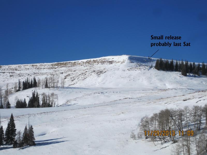
Darce noticed this slide from last Saturday. |
| type | aspect/elevation | characteristics |
|---|

|
|
LIKELIHOOD
 LIKELY
UNLIKELY
SIZE
 LARGE
SMALL
TREND
 INCREASING DANGER
SAME
DECREASING DANGER
|
|
description
Last weeks wind did a number on the snowpack and in general things have relaxed quite a bit. However, the Skyline is a big place and there could still be a rogue slab or two lurking along the leeward side of upper elevation ridges that'll be reactive to the additional weight of a rider or hiker this weekend. Look for and avoid any fat looking wind drifts, especially if they sound hollow like a drum. Remember- even a small slide this time of year can take you for a nasty ride through rocks and stumps, quickly ruining your day and perhaps delivering a season ending injury.
The Big Drift definitely not living up to its reputation. Last week the winds howled out of the east, stripping what little snow existed on much of our upper elevation terrain. |
 |
weather High pressure remains over the region through the weekend giving us mostly sunny skies, light winds, and temperatures climbing into the mid to upper 30's with overnight lows dipping into the mid 20's. Monday should be warm and windy with a dramatic change in the weather pattern on tap for Tuesday through the end of the week. Cold air is a given, but there is much uncertainty to how much snow will accumulate during the week. |
| general announcements Remember your information can save lives. Please let us and the rest of the community know what your are seeing out there by submitting snow and avalanche conditions. This is a great time of year to schedule a free avalanche awareness presentation for your group or club. Contact either Craig Gordon or Brett Kobernik by emailing us: Donate to your favorite non-profit –The Friends of the Utah Avalanche Center. The UAC depends on contributions from users like you to support our work. The information in this advisory is from the US Forest Service which is solely responsible for its content. This advisory describes general avalanche conditions and local variations always occur. This advisory will be updated by 8:00 PM December 7th. |


.jpg)