
| During the month of April, Mark Miller will donate $75 to the charity of your choice (5 to chose from, including the Utah Avalanche Center!) Mark Miller Subaru has raised over $300k in the previous 6 Do Good Feel Good events. More Info here |  |
| During the month of April, Mark Miller will donate $75 to the charity of your choice (5 to chose from, including the Utah Avalanche Center!) Mark Miller Subaru has raised over $300k in the previous 6 Do Good Feel Good events. More Info here | |
| Advisory: Skyline Area Mountains | Issued by Brett Kobernik for Friday - November 22, 2013 - 8:21pm |
|---|


|
bottom line There is a MODERATE avalanche danger due to new snow and wind. Human triggered avalanches are possible, natural avalanches are not likely. Approach any fresh drift with caution and that goes double if it is on a high elevation north facing slope. Keep in mind that even small avalanches are more dangerous at this time of the season due to rocks, logs, and stumps just under the snow surface which can cause serious injury very easily.
|
 |
special announcement We will be publishing the Skyline advisory on Friday nights between 7 and 8pm this season. |
 |
current conditions New snow and strong east winds make the headlines. On the Photo: drifting snow along the skyline - Cade Beck
|
 |
recent activity There was one avalanche reported today due to the strong winds. It was actually a natural cornice fall on one of the usual suspect slopes.
|
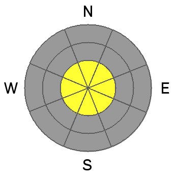
| type | aspect/elevation | characteristics |
|---|

|
|
LIKELIHOOD
 LIKELY
UNLIKELY
SIZE
 LARGE
SMALL
TREND
 INCREASING DANGER
SAME
DECREASING DANGER
|
|
description
With strong winds like we've had, it is very difficult to nail down the exact locations where these wind slabs will be. The deal is on Saturday, anticipate any large fresh looking pillows to be sensitive. There is a chance that they will be so stiff and stubborn that they won't move but don't trust them until you've done a bunch of sleuthing and are satisfied that they are stable. This avalanche problem will be most pronounced at the upper elevations. |
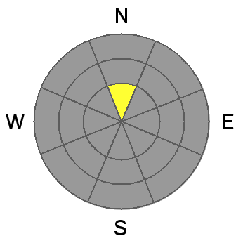
| type | aspect/elevation | characteristics |
|---|

|
|
LIKELIHOOD
LIKELY
UNLIKELY
SIZE
LARGE
SMALL
TREND
 INCREASING DANGER
SAME
DECREASING DANGER
|
|
description
There was some older sugary snow that I was able to identify along the north facing slopes above Fairview Canyon. Other folks have noted that they have seen some as well. This older weak sugary snow will most likely act as a weak layer with the addition of the new snow and especially in areas where the wind has drifted snow. The older snow is only present on the more northerly facing slopes at the higher elevations. You don't have to worry about this avalanche problem on east, south and west facing slopes and all slopes below around 9000 feet. |
 |
weather A large storm system that will pass to our south through the weekend will keep periods of snow possible for the Skyline. 2 to 6 inches more into Sunday is possible. The strong east winds should slow a bit but will stay in the moderate range on Saturday and decrease more on Sunday. Ridgetop temperatures will be fairly mild in the mid to upper 20s. |
| general announcements Remember your information can save lives. Please let us and the rest of the community know what your are seeing out there by submitting snow and avalanche conditions. This is a great time of year to schedule a free avalanche awareness presentation for your group or club. Contact either Craig Gordon or Brett Kobernik by emailing us: Donate to your favorite non-profit –The Friends of the Utah Avalanche Center. The UAC depends on contributions from users like you to support our work. The information in this advisory is from the US Forest Service which is solely responsible for its content. This advisory describes general avalanche conditions and local variations always occur. This advisory will be updated by 8:00 PM November 29th. |


.jpg)

 northern end of the Skyline above Fairview Canyon there is up to around 10 inches of new snow from the last few days. It appears that the southern end of the Skyline around I-70 has picked up a bit more with perhaps a foot or more. We only have limited information because limited snow cover has restricted travel but this is changing. Around the top of Fairview Canyon there is an average of about 15 inches of snow and probably almost twice that much on the southern end of the Skyline. This of course is going to vary dramatically with elevation with only the highest terrain holding much snow. Also, the strong east winds have been blowing and drifting snow so you will find spots that have been blown bare and spots with very deep drifts.