SPECIAL ANNOUNCEMENT |
 |
Next Saturday April 7th will be the last of our regularly scheduled advisories for the Manti-Skyline. |
|
|
BOTTOM LINE
Danger by aspect and elevation on slopes approaching 35° or steeper.
(click HERE for tomorrow's danger rating)
|
Danger Rose Tutorial
|
The avalanche danger on all steep slopes will rise from Level 1 (LOW) this morning to Level 2 (MODERATE) with daytime heating. Both human triggered wet slabs and sluffs are possible, especially during the heat of the day. |
|
|
CURRENT CONDITIONS |

|
Skies are clear and southwesterly winds are blowing 10-15 mph along the ridges. Overnight low temperatures were balmy, barely dipping into the upper 30’s and low 40’s. Despite the recent big melt down, during the winter that wasn’t, yesterday we found surprisingly good riding and turning conditions. Supportable snow exists on mid and upper elevation south aspects. On the other side of the compass, shallow creamy powder will be found on upper elevation northerly facing terrain. |
|
|
RECENT ACTIVITY |

|
No new avalanche activity to report. |
|
|
THREAT #1 |

|
| WHERE |
PROBABILITY |
SIZE |
TREND |

|
|
|
|
| |
|
|
Over the next
24 hours.
|
|
|

Steep terrain that has a shallow snowpack where bushes and rocks are poking through are likely places where we could trigger a deep dangerous avalanche today.
While we don’t have the deep snowpack we’re used to this time of year, the surface snow is providing outstanding hill climbing conditions and folks have been out testing nearly all the steep terrain surrounding the Skyline without incident…. that’s the good news. The bad news is… steep slopes that have a thin, punchy feeling snowpack may get cranky and become more reactive to the weight of a rider, especially late in the day after the snowpack has soaked up the days heat. So how does this kind of snow condition feel under our sled? If my track is gouging to weak sugary snow near the ground and I can feel the supportability of the snowpack diminishing, then I know I’ve overstayed my welcome and it’s time to get off of and out from under steep slopes. Once initiated, avalanches can break into weaker layers of snow resulting in a larger slide than you might’ve bargained for. In addition, you’ll want to avoid terrain traps like gullies and road cuts where huge piles of bone snapping debris can stack up deeply. |
|
|
THREAT #2 |

|
| WHERE |
PROBABILITY |
SIZE |
TREND |
|
|
|
|
| |
|
|
Over the next
24 hours.
|
|
|
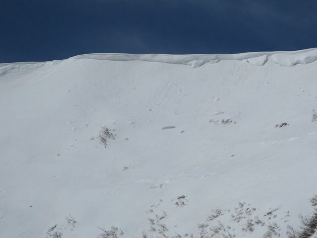
Cornices are starting to peel off naturally and may break further back than you might anticipate. In addition, a big chunk of cornice slamming down on the slope below may initiate an avalanche. Probably best to avoid traveling on or near these unpredictable pieces of snow. |
|
|
MOUNTAIN WEATHER |

|
Under mostly sunny skies, southerly winds start to crank throughout the day, gusting into the 70’s along the ridges by about dinner time. Temperatures soar into record breaking territory, reaching into the low 60’s. Winds diminish behind the cold front early Sunday morning and temperatures crash into the mid 20’s. Snow accumulations are underwhelming…. maybe 3” or so by Sunday afternoon. High pressure builds for the early part of next week. |
|
|
GENERAL ANNOUNCEMENTS |
The information in this advisory expires 24 hours after the date and time posted, but will be updated by 7:00 AM Saturday, April 7th. If you’re getting out and about and trigger an avalanche or see anything interesting please drop me an email at craig@utahavalanchecenter.org or call 801-231-2170 Also, now is a great time to schedule one of our free avalanche awareness presentations for your group or club. Email or call me and we’ll get you booked before things get too crazy.
This information does not apply to developed ski areas or highways where avalanche control is normally done. This advisory is from the U.S.D.A. Forest Service, which is solely responsible for its content. This advisory describes general avalanche conditions and local variations always occur.
This advisory provided by the USDA Forest Service, in partnership with:
The Friends of the Utah Avalanche Center, Utah Division of State Parks and Recreation, Utah Division of Emergency Management, Salt Lake County, Salt Lake Unified Fire Authority and the friends of the La Sal Avalanche Center. See ourSponsors Pagefor a complete list.
|
|
|
This information does not apply to developed ski areas or highways where avalanche control is normally done. This advisory is from the U.S.D.A. Forest Service, which is solely responsible for its content. This advisory describes general avalanche conditions and local variations always occur. |
|
This advisory provided by the USDA Forest Service, in partnership with:
The Friends of the Utah Avalanche Center, Utah Division of State Parks and Recreation, Utah Division of Emergency Management, Salt Lake County, Salt Lake Unified Fire Authority and the friends of the La Sal Avalanche Center. See our Sponsors Page for a complete list. |
