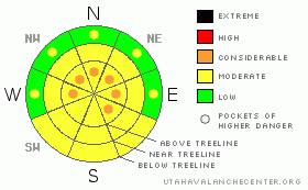
BOTTOM LINE
Danger by aspect and elevation on slopes approaching 35° or steeper.
(click HERE for tomorrow's danger rating)
|
Danger Rose Tutorial
|
Advisory reviewed, edited and approved by Brett Kobernik.
In the upper elevation west through southeast facing slopes we have pockets of Level 3 (CONSIDERABLE) avalanche danger will be found and human triggered avalanches are probable on all steep slopes where a strong slab overlays a thin, weak snowpack.
At mid to lower elevation we have a Level 2 ( Moderate) avalanche danger for rapid warming as the sun heats things up. Watch for wet loose sluffs as the danger could increase to MODERATE with pockets of CONSIDERABLE. Stay out from underneath steep slopes as the snow heats up and things start to become damp. |
|
|
CURRENT CONDITIONS |

|
It was a warm week on the Skyline with mountain temps at or above freezing during the day, night temps dipping into the 20's. Thursday the northeast winds picked up and started drifting what loose powder there was left in the higher terrain.The snow surface is now a mixed bag on many slopes with sun crusts, wind crust and damp snow.There is very nice soft settled powder on the wind sheltered shaded aspects. Riding and traveling conditions are good and its easy to get around on the sled. |
|
|
RECENT ACTIVITY |

|
The Skyline went through a significant natural avalanche cycle during last weekends big storm and the rapid warming from Sunday and Monday. Avalanches were very large and destructive running full track and snapping mature trees. It appears that all of them involved the weak facets from early in the season as well as the layer that formed in early February. Click HEREfor a list of all the recent avalanches.
Here is a link to a video of a avalanche accident that happened in the Uinta mountains last Sunday. The rider was high marking when a avalanche buried him with out a beacon on. DETAILS |
|
|
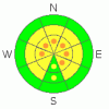
THREAT #1 |

|
| WHERE |
PROBABILITY |
SIZE |
TREND |
|
|
|
|
| |
|
|
Over the next
24
hours.
|
|
|
There are a variety of weak layers in the snowpack. The one that stands out is the facets that formed in early February from a cold dry spell. I suspect that this weak layer could still be touchy to the weight of a rider and could break 2’-3’ deep. If you were trigger a avalanche it could step down into weaker layers at the ground making it a more dangerous avalanche, taking out the seasons snowpack. Don’t be fooled into seeing tracks on the slope and thinking it's ok, many times with these weak layers it can avalanche after the second, third, fifth, or tenth rider on the slope. Best way to stay safe is to avoid the steeps and ride the lower angle trees and meadows.
Here's a video of testing done on Wednesday: DETAILS |
|
|
THREAT #2 |

|
| WHERE |
PROBABILITY |
SIZE |
TREND |
|
|
|
|
| |
|
|
Over the next
24
hours.
|
|
|
As things start to heat up in the mid morning early afternoon the southernly facing slopes will be taking in a lot of heat. As the day progresses you might see some wet snow avalanches. Best way to avoid this is to not be hanging out in or below sunny slopes as the day warms up. |
|
|
MOUNTAIN WEATHER |

|
We have a beautiful weekend on tap for the Skyline with clear skies and warm temperatures. Saturday we will have a cold start with temps in the 20's and rapidly warming into the 40's by noon. The winds will be calm and out of the north at 3 to 5mph overnight lows dip back into the 20's. On Sunday we will have sunny skies again with a high of 39. However, the west southwest winds pick up between 13 and 16 mph. The extended forecast shows partly cloudy skies by Monday and then a return to sunny skies as the week progresses, with a slight chance of snow showers next Friday. |
|
|
GENERAL ANNOUNCEMENTS |
The information in this advisory expires 24 hours after the date and time posted, but will be updated by 7:00 AM Saturday, March 17th. If you’re getting out and about and trigger an avalanche or see anything interesting please drop me an email at craig@utahavalanchecenter.org or call 801-231-2170 Also, now is a great time to schedule one of our free avalanche awareness presentations for your group or club. Email or call me and we’ll get you booked before things get too crazy.
This information does not apply to developed ski areas or highways where avalanche control is normally done. This advisory is from the U.S.D.A. Forest Service, which is solely responsible for its content. This advisory describes general avalanche conditions and local variations always occur.
This advisory provided by the USDA Forest Service, in partnership with:
The Friends of the Utah Avalanche Center, Utah Division of State Parks and Recreation, Utah Division of Emergency Management, Salt Lake County, Salt Lake Unified Fire Authority and the friends of the La Sal Avalanche Center. See ourSponsors Pagefor a complete list.
|
|
|
This information does not apply to developed ski areas or highways where avalanche control is normally done. This advisory is from the U.S.D.A. Forest Service, which is solely responsible for its content. This advisory describes general avalanche conditions and local variations always occur. |
|
This advisory provided by the USDA Forest Service, in partnership with:
The Friends of the Utah Avalanche Center, Utah Division of State Parks and Recreation, Utah Division of Emergency Management, Salt Lake County, Salt Lake Unified Fire Authority and the friends of the La Sal Avalanche Center. See our Sponsors Page for a complete list. |
