AVALANCHE WARNING »
Dangerous avalanche conditions are occuring or are imminent.
Backcountry travel in avalanche terrain is not recommended.
|
 |
Notice: An Avalanche Warning remains in effect for the mountains surrounding the Manti-Skyline. Strong winds and recent snowfall have overloaded a weak snowpack, creating a HIGH avalanche danger. Avalanches can be triggered from a distance and on lower angle terrain. Dangerous human triggered avalanches are likely. People should avoid being on or under steep wind drifted slopes. |
|
|
SPECIAL ANNOUNCEMENT |
 |
Looking for a safe way to ride Utah's powder during High backcountry avy danger? Click
here for discounted lift tickets provided through a great partnership with local ski resorts and Ski Utah. |
|
|
BOTTOM LINE
Danger by aspect and elevation on slopes approaching 35° or steeper.
(click HERE for tomorrow's danger rating)
|
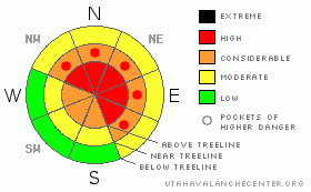
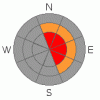
Danger Rose Tutorial
|
In the wind zone at upper elevations a Level 4 (HIGH) avalanche danger exists for both fresh wind drifts and for deeper slides in terrain where a strong slab overlays a thin, weak snowpack. Human triggered avalanches are likely on steep wind drifted slopes, especially those with an easterly component to their aspect.
At mid elevations a Level 3 (CONSIDERABLE) avalanche danger will be found and human triggered avalanches are probable on all steep wind drifted slopes.
A LEVEL 2 (MODERATE) avalanche danger will be found on leeward slopes at lower elevations and human triggered avalanches are possible. |
|
|
CURRENT CONDITIONS |

|
Light snow continues to fall this morning as the last gasp from an active storm pattern moves through the region. The Skyline picked up an additional 8” of snow overnight adding to the foot plus which fell Wednesday. West and northwest winds are blowing 15-30 mph along the ridges. |
|
|
RECENT ACTIVITY |

|
No new avalanches to report, but I suspect much of the upper elevation terrain surrounding the Skyline experienced a natural avalanche cycle.
Click here for recent observations from the region. |
|
|
THREAT #1 |

|
| WHERE |
PROBABILITY |
SIZE |
TREND |

|
|
|
|
| |
|
|
Over the next
24 hours.
|
|
|
Recent raging winds and heavy snowfall have overloaded a variety of weak layers and many slopes wait for a human trigger to come along and knock the legs out from underneath them. Today, most avalanches will break 2’-3’ deep on a layer of weak surface snow formed in early February. They’ll pack a punch, quickly ruining a great day of powder riding. Today you’ll want to continue avoiding steep wind drifted slopes, especially those facing the north half of the compass. |
|
|
THREAT #2 |

|
| WHERE |
PROBABILITY |
SIZE |
TREND |

|
|
|
|
| |
|
|
Over the next
24 hours.
|
|
|
Deep, dangerous avalanches breaking to the ground aren’t out of the question. Steep, rocky, upper elevation, north facing terrain where a thin, weak snowpack is connected to strong snow or terrain that avalanched near the ground in mid January are likely suspects. |
|
|
THREAT #3 |

|
| WHERE |
PROBABILITY |
SIZE |
TREND |
|
|
|
|
| |
|
|
Over the next
24 hours.
|
|
|
Cornices have grown huge along the leeward side of mid and upper elevation ridges, breaking back further than you might think. |
|
|
MOUNTAIN WEATHER |

|
Light snow will continue to fall this morning, though accumulations will only be in the 1”-3” range. Northerly winds remain pretty burly along the ridges, blowing 15-30 mph and temperatures only climb into the low teens. We’ll probably see some clearing around midday, before clouds slide into the region and light snow develops. Cloudy skies with occasional snow showers continue through Saturday. Sunday will be sunny and warm. |
|
|
GENERAL ANNOUNCEMENTS |
The information in this advisory expires 24 hours after the date and time posted, but will be updated by 7:00 AM Saturday, March 2nd. If you’re getting out and about and trigger an avalanche or see anything interesting please drop me an email at craig@utahavalanchecenter.org or call 801-231-2170 Also, now is a great time to schedule one of our free avalanche awareness presentations for your group or club. Email or call me and we’ll get you booked before things get too crazy. |
|
|
This information does not apply to developed ski areas or highways where avalanche control is normally done. This advisory is from the U.S.D.A. Forest Service, which is solely responsible for its content. This advisory describes general avalanche conditions and local variations always occur. |
|
This advisory provided by the USDA Forest Service, in partnership with:
The Friends of the Utah Avalanche Center, Utah Division of State Parks and Recreation, Utah Division of Emergency Management, Salt Lake County, Salt Lake Unified Fire Authority and the friends of the La Sal Avalanche Center. See our Sponsors Page for a complete list. |
