AVALANCHE WARNING »
Dangerous avalanche conditions are occuring or are imminent.
Backcountry travel in avalanche terrain is not recommended.
|
 |
Notice: An Avalanche Warning remains in effect for the mountains surrounding the Manti-Skyline. Continued strong winds have overloaded a very weak and fragile snowpack and created a HIGH avalanche danger. Dangerous human triggered avalanches are likely. People should avoid steep wind drifted slopes. |
|
|
SPECIAL ANNOUNCEMENT |
 |
It is with great sadness to report yet another avalanche accident which occurred on Thursday resulting in the death of 24-year-old Timothy Robert Baker of Salt Lake City. He was killed in a backcountry avalanche he triggered in Dutch Draw. Our thoughts, prayers, and condolences go out to the friends and family of Mr. Baker. |
|
|
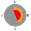
BOTTOM LINE
Danger by aspect and elevation on slopes approaching 35° or steeper.
(click HERE for tomorrow's danger rating)
|
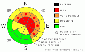
Danger Rose Tutorial
|
In the wind zone at upper elevations a Level 4 (HIGH) avalanche danger exists for both fresh wind drifts and for deeper slides in terrain where a strong slab overlays a thin, weak snowpack. Human triggered avalanches are likely on steep wind drifted slopes, especially those with an easterly component to their aspect.
At mid elevations a Level 3 (CONSIDERABLE) avalanche danger will be found and human triggered avalanches are probable on all steep wind drifted slopes.
A Level 1 (LOW) avalanche danger will be found on low angle slopes and on wind sheltered terrain at lower elevations. |
|
|
CURRENT CONDITIONS |

|
Skies are clear for the moment, temperatures in the upper 20's and low 30's, and southwest winds are blowing 15-35 mph along the ridges. Soft, settled powder is an elusive commodity, but can still be found on wind sheltered slopes. |
|
|
RECENT ACTIVITY |

|
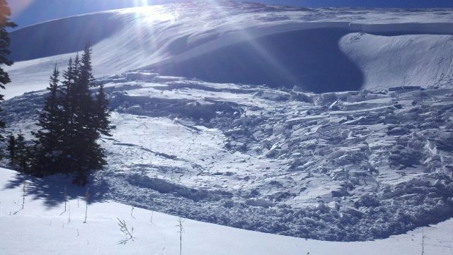
Lots of cracking and collapsing along with large, pockety avalanches reported on steep east, north, and northeast facing slopes surrounding the Skyline. Steve Cote reported nearly all of the large, east facing bowl at the head of South Lake Fork avalanched.... yikes!
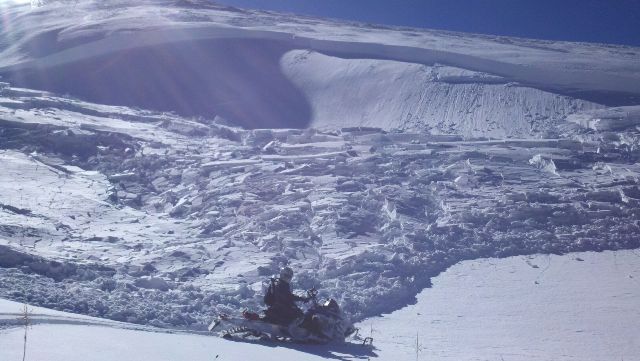
This remotely triggered slide was initiated from about 40 yards away.
Click here for a trip report from Friday.
Huge thanks for all the great info this week. Many thanks to Deven, Steve, Darce, and Seth.... y'all rock!
Click here for recent observations from the region. |
|
|
THREAT #1 |

|
| WHERE |
PROBABILITY |
SIZE |
TREND |
|
|
|
|
| |
|
|
Over the next
24 hours.
|
|
|
Nothing has changed with our problem child, the weak sugary depth hoar near the ground. Avalanches triggered today on steep wind loaded slopes can easily break into these deeply buried dragons, creating a deep, dangerous slide. In addition, avalanches can be triggered from a distance and on relatively flat terrain. |
|
|
THREAT #2 |

|
| WHERE |
PROBABILITY |
SIZE |
TREND |

|
|
|
|
| |
|
|
Over the next
24 hours.
|
|
|
Nuking west and southwest winds from Wednesday night’s storm formed hard, cohesive slabs on the leeward side of ridges. As Darce puts it- "Nuking winds are an understatement for the Plateau, the place looks like Antarctica with the exception of some ridge lines that are again blown to dirt."
Today's hurricane force winds will continue to load leeward slopes as well as terrain features like chutes and gullies, and drifting will occur lower downslope than you might expect. Today’s slabs will be break deeper than you’d anticipate. |
|
|
THREAT #3 |

|
| WHERE |
PROBABILITY |
SIZE |
TREND |
|
|
|
|
| |
|
|
Over the next
24 hours.
|
|
|
Cornices have grown huge along the leeward side of mid and upper elevation ridges and may break further back than you might expect. |
|
|
MOUNTAIN WEATHER |

|
Clear skies this morning should be short-lived as a cold front is slated to move through the area early this afternoon, bringing strong winds and at least a few inches of snow. Southwest winds switch to the west and continue to crank along the ridges, gusting into the 40’s and 50’s. Showers linger through the evening before tapering off overnight and temperatures dive into the single digits. |
|
|
GENERAL ANNOUNCEMENTS |
The information in this advisory expires 24 hours after the date and time posted, but will be updated by 7:00 AM Sunday, February 26th. If you’re getting out and about and trigger an avalanche or see anything interesting please drop me an email at craig@utahavalanchecenter.org or call 801-231-2170 Also, now is a great time to schedule one of our free avalanche awareness presentations for your group or club. Email or call me and we’ll get you booked before things get too crazy. |
|
|
This information does not apply to developed ski areas or highways where avalanche control is normally done. This advisory is from the U.S.D.A. Forest Service, which is solely responsible for its content. This advisory describes general avalanche conditions and local variations always occur. |
|
This advisory provided by the USDA Forest Service, in partnership with:
The Friends of the Utah Avalanche Center, Utah Division of State Parks and Recreation, Utah Division of Emergency Management, Salt Lake County, Salt Lake Unified Fire Authority and the friends of the La Sal Avalanche Center. See our Sponsors Page for a complete list. |
