AVALANCHE WARNING »
Dangerous avalanche conditions are occuring or are imminent.
Backcountry travel in avalanche terrain is not recommended.
|
 |
Notice: An Avalanche Warning is in effect the mountains of northern and central Utah, including the Manti-Skyline. Strong winds and dense heavy snow has created a HIGH avalanche danger. People should avoid steep wind drifted slopes. |
|
|
SPECIAL ANNOUNCEMENT |
 |
It is with great sadness to report yet another avalanche accident which resulted in the death of 24-year-old Timothy Robert Baker of Salt Lake City. He was killed in a backcountry avalanche he triggered in Dutch Draw. Our thoughts, prayers, and condolences go out to the friends and family of Mr. Baker. |
|
|
BOTTOM LINE
Danger by aspect and elevation on slopes approaching 35° or steeper.
(click HERE for tomorrow's danger rating)
|

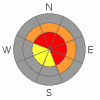
Danger Rose Tutorial
|
In the wind zone at upper elevations a Level 4 (HIGH) avalanche danger exists for both fresh wind drifts and for deeper slides in terrain where a strong slab overlays a thin, weak snowpack. Human triggered avalanches are likely on steep wind drifted slopes, especially those with an easterly component to their aspect.
At mid elevations a Level 3 (CONSIDERABLE) avalanche danger will be found and human triggered avalanches are probable on all steep wind drifted slopes.
A Level 1 (LOW) avalanche danger will be found on low angle slopes and at lower elevations which received less snow and wind. |
|
|
CURRENT CONDITIONS |

|
Skies are clear, temperatures in the single digits, and northwest winds are blowing 10-20 mph along the ridges. |
|
|
RECENT ACTIVITY |

|
Pockety avalanches reported on steep east facing slopes surrounding the Skyline.
Click here for recent observations from the region. |
|
|
THREAT #1 |

|
| WHERE |
PROBABILITY |
SIZE |
TREND |

|
|
|
|
| |
|
|
Over the next
24 hours.
|
|
|
Nuking west and southwest winds from Wednesday nights storm formed hard, cohesive slabs on the leeward side of ridges, around terrain features like chutes and gullies, and lower downslope than you might expect. Drifting is widespread and today’s slabs will be break deeper than you’d anticipate. |
|
|
THREAT #2 |

|
| WHERE |
PROBABILITY |
SIZE |
TREND |
|
|
|
|
| |
|
|
Over the next
24 hours.
|
|
|
Nothing has changed with our problem child, the weak sugary depth hoar near the ground. Avalanches triggered today on steep wind loaded slopes can easily break into these deeply buried dragons, creating a deep, dangerous slide. |
|
|
THREAT #3 |

|
| WHERE |
PROBABILITY |
SIZE |
TREND |

|
|
|
|
| |
|
|
Over the next
24 hours.
|
|
|
Cornices have grown huge along the leeward side of mid and upper elevation ridges and may break further back than you might expect. |
|
|
MOUNTAIN WEATHER |

|
Sunny skies with temperatures warming into the low 30's is on tap as brief high pressure builds for the region today. Northwesterly winds will average in the teens with gusts in the 20's along the high ridges. Winds increase on Saturday ahead of a storm similar to the last. Lots of huff, but not much fluff. |
|
|
GENERAL ANNOUNCEMENTS |
The information in this advisory expires 24 hours after the date and time posted, but will be updated by 7:00 AM Saturday, February 25th. If you’re getting out and about and trigger an avalanche or see anything interesting please drop me an email at craig@utahavalanchecenter.org or call 801-231-2170 Also, now is a great time to schedule one of our free avalanche awareness presentations for your group or club. Email or call me and we’ll get you booked before things get too crazy. |
|
|
This information does not apply to developed ski areas or highways where avalanche control is normally done. This advisory is from the U.S.D.A. Forest Service, which is solely responsible for its content. This advisory describes general avalanche conditions and local variations always occur. |
|
This advisory provided by the USDA Forest Service, in partnership with:
The Friends of the Utah Avalanche Center, Utah Division of State Parks and Recreation, Utah Division of Emergency Management, Salt Lake County, Salt Lake Unified Fire Authority and the friends of the La Sal Avalanche Center. See our Sponsors Page for a complete list. |
