SPECIAL ANNOUNCEMENT |
 |
Discount lift tickets to your favorite resorts are available in partnership with Ski Utah.
Click here to purchase. |
|
|
BOTTOM LINE
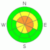
Danger by aspect and elevation on slopes approaching 35° or steeper.
(click HERE for tomorrow's danger rating)
|

Danger Rose Tutorial
|
A Level 3 (CONSIDERABLE) avalanche danger will be found on steep, upper elevation wind drifted slopes, especially those facing the north half of the compass. Human triggered avalanches are likely on slopes where a thick, strong feeling slab overlays weak, sugary snow near the ground.
At mid elevations a Level 2 (MODERATE) avalanche danger will be found and human triggered avalanches are possible on steep wind drifted slopes.
A Level 1 (LOW) avalanche danger will be found on low angle slopes and at lower elevations which received less snow and wind. |
|
|
CURRENT CONDITIONS |

|
Skies cleared late yesterday and temperatures crashed into low teens and single digits. West-northwest winds are blowing 15-25 mph along the ridges. The storm was pretty underwhelming, but not a total bust. 6"-8" of snow fell on the Skyline and excellent riding and turning conditions won't be hard to find. |
|
|
RECENT ACTIVITY |

|
No new avalanches to report from yesterday, collapsing and shooting cracks is a common theme throughout the range.
Click here for recent observations from the region. |
|
|
THREAT #1 |

|
| WHERE |
PROBABILITY |
SIZE |
TREND |
|
|
|
|
| |
|
|
Over the next
24 hours.
|
|
|
We’re still experiencing big, booming collapses and the overall structure of our snowpack is a gong show... it's the weakest I’ve seen statewide. (This observation and video pretty much sums it up)
While the vast majority of slopes surrounding the Skyline offer safe riding and they’re good to go, there’s plenty of terrain where you could still trigger a deep, dangerous slide that breaks to the ground. Likely suspects are steep, northerly facing slopes at upper elevations, especially where the snowpack is thin and the terrain rocky. |
|
|
THREAT #2 |

|
| WHERE |
PROBABILITY |
SIZE |
TREND |

|
|
|
|
| |
|
|
Over the next
24 hours.
|
|
|
West and northwest winds bumped into the 30's during the storm yesterday, forming sensitive wind drifts along the leeward side of upper elevation ridges. Once triggered, today's manageable slabs can get out of hand in a hurry, especially if they break into weaker layers of snow deeper in the snowpack. |
|
|
MOUNTAIN WEATHER |

|
High pressure returns to the region for a brief time today giving us clearing skies with temperatures climbing into the 20’s. West and northwesterly wind increase late in the day, gusting into the 40’s along the high ridges. Snow develops tonight into Tuesday and a quick hitting system gives us an additional 4”-6” by tomorrow afternoon. A stronger storm is slated to impact the region late Wednesday. |
|
|
GENERAL ANNOUNCEMENTS |
The information in this advisory expires 24 hours after the date and time posted, but will be updated by 7:00 AM Saturday, February 25th. If you’re getting out and about and trigger an avalanche or see anything interesting please drop me an email at craig@utahavalanchecenter.org or call 801-231-2170 Also, now is a great time to schedule one of our free avalanche awareness presentations for your group or club. Email or call me and we’ll get you booked before things get too crazy. |
|
|
This information does not apply to developed ski areas or highways where avalanche control is normally done. This advisory is from the U.S.D.A. Forest Service, which is solely responsible for its content. This advisory describes general avalanche conditions and local variations always occur. |
|
This advisory provided by the USDA Forest Service, in partnership with:
The Friends of the Utah Avalanche Center, Utah Division of State Parks and Recreation, Utah Division of Emergency Management, Salt Lake County, Salt Lake Unified Fire Authority and the friends of the La Sal Avalanche Center. See our Sponsors Page for a complete list. |
