SPECIAL ANNOUNCEMENT |
 |
A Special Avalanche Advisory has been issued for the Manti-Skyline. Heavy snowfall today into tonight will increase the avalanche danger through the Holiday weekend. |
|
|
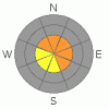
BOTTOM LINE
Danger by aspect and elevation on slopes approaching 35° or steeper.
(click HERE for tomorrow's danger rating)
|
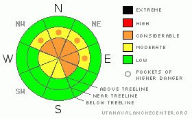
Danger Rose Tutorial
|
Dangerous avalanche conditions will develop if the storm materializes. A Level 3 (CONSIDERABLE) avalanche danger will be found on steep, upper elevation wind drifted slopes, especially those facing the north half of the compass. Human triggered avalanches are likely on slopes where a thick, strong feeling slab overlays weak, sugary snow near the ground.
At mid elevations a Level 2 (MODERATE) avalanche danger will be found and human triggered avalanches are possible on steep wind drifted slopes.
A Level 1 (LOW) avalanche danger will be found on low angle slopes and at lower elevations which receive less snow and wind. |
|
|
CURRENT CONDITIONS |

|
Light snow began early this morning and so far just an inch or two has accumulated. Temperatures are in the mid 20's and westerly winds are blowing 15-25 mph along the ridges. |
|
|
RECENT ACTIVITY |

|
On Friday a few shallow slides were spotted on steep southerly facing slopes and all were manageable, running within last weekend’s storm snow. Also, collapsing and shooting cracks is a common theme throughout the range.
Click here for recent observations from the region. |
|
|
THREAT #1 |

|
| WHERE |
PROBABILITY |
SIZE |
TREND |

|
|
|
|
| |
|
|
Over the next
24 hours.
|
|
|
The snowpack continues to adjust to the big January storm and this weekends storm could reactivate the weak layers of snow near the ground. We’re still experiencing big, booming collapses and the overall structure of our snowpack is a gong show... it's the weakest I’ve seen statewide. (This observation and video pretty much sums it up)
Yes, the vast majority of the slopes surrounding the Skyline offer safe riding and they’re good to go. However, there’s plenty of terrain where you could still trigger a deep, dangerous slide that breaks to the ground. Just like an Elvis or a UFO sighting, they’re elusive…. but once revealed, life changing. The most likely terrain to encounter this condition is going to be steep, northerly facing slopes at upper elevations, especially where the snowpack is thin and the terrain rocky. |
|
|
THREAT #2 |

|
| WHERE |
PROBABILITY |
SIZE |
TREND |
|
|
|
|
| |
|
|
Over the next
24 hours.
|
|
|
Once the storm gets going and the new snow starts to stack up it will become more sensitive to the weight of a rider. Today’s surface snow instabilities will be easy to manage, but could knock you into a tree and ruin your day in a hurry. Should winds pick up carefully re-evaluate your terrain choices, especially if your travels are taking you into steep, leeward upper elevation terrain. |
|
|
MOUNTAIN WEATHER |

|
Today we should see periods of heavy snow with 8”-16” by Monday morning a strong possibility. West and northwest winds gust into the 20’s and 30’s along the high ridges and temperatures begin to dive into the low teens. High pressure briefly returns Monday, before a moist northwest flow brings additional snow Tuesday through Thursday. |
|
|
GENERAL ANNOUNCEMENTS |
The information in this advisory expires 24 hours after the date and time posted, but will be updated by 7:00 AM Monday, February 20th. If you’re getting out and about and trigger an avalanche or see anything interesting please drop me an email at craig@utahavalanchecenter.org or call 801-231-2170 Also, now is a great time to schedule one of our free avalanche awareness presentations for your group or club. Email or call me and we’ll get you booked before things get too crazy. |
|
|
This information does not apply to developed ski areas or highways where avalanche control is normally done. This advisory is from the U.S.D.A. Forest Service, which is solely responsible for its content. This advisory describes general avalanche conditions and local variations always occur. |
|
This advisory provided by the USDA Forest Service, in partnership with:
The Friends of the Utah Avalanche Center, Utah Division of State Parks and Recreation, Utah Division of Emergency Management, Salt Lake County, Salt Lake Unified Fire Authority and the friends of the La Sal Avalanche Center. See our Sponsors Page for a complete list. |
