AVALANCHE WATCH »
The risk of an avalanche is expected to increase significantly
but the timing and location are still uncertain. Stay tuned for updates.
|
 |
Notice: An avalanche watch has been issued for the Manti-Skyline. Heavy snowfall starting overnight continuing into Sunday is expected to increase the avalanche danger through the Holiday weekend. |
|
|
SPECIAL ANNOUNCEMENT |
|
|
|
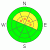
BOTTOM LINE
Danger by aspect and elevation on slopes approaching 35° or steeper.
(click HERE for tomorrow's danger rating)
|

Danger Rose Tutorial
|
Pockets of Level 3 (CONSIDERABLE) avalanche danger are isolated to steep, upper elevation wind drifted slopes, especially those facing the north half of the compass. While not widespread, human triggered avalanches are likely on slopes where a thick, strong feeling slab overlays weak, sugary snow near the ground.
At mid elevations a Level 2 (MODERATE) avalanche danger will be found and human triggered avalanches are possible on steep, northerly facing slopes.
Slopes facing the south half of the compass offer Level 1 (LOW) avalanche danger. |
|
|
CURRENT CONDITIONS |

|
Skies remained clear overnight and it’ll be a beautiful morning on the Skyline. Currently, west-southwest winds are blowing 10-20 mph and temperatures are in the upper teens and low 20’s. Sunny slopes are slightly crusted and lower elevation north facing terrain is like riding in a sandbox. However, with a little elevation gain you’ll find a supportable base with about a foot of soft settled powder on top. |
|
|
RECENT ACTIVITY |

|
A few shallow slides were spotted on steep southerly facing slopes and all were manageable, running within last weekend’s storm snow. Also, collapsing and shooting cracks is a common theme throughout the range.
Click here for recent observations from the region. |
|
|
THREAT #1 |

|
| WHERE |
PROBABILITY |
SIZE |
TREND |
|
|
|
|
| |
|
|
Over the next
24 hours.
|
|
|
The snowpack continues to adjust to the big January storm and last weekend’s snow didn’t have enough water or wind to tip the balance. However, the lack of avalanche activity shouldn’t lull us into a false sense of snow stability. We’re still experiencing big, booming collapses and the overall structure of our snowpack is a gong show... it's the weakest I’ve seen statewide. (This observation and video pretty much sums it up)
Yes, the vast majority of the slopes surrounding the Skyline offer safe riding and they’re good to go. However, there’s plenty of terrain where you could still trigger a deep, dangerous slide that breaks to the ground. Just like an Elvis or a UFO sighting, they’re elusive…. but once revealed, life changing. The most likely terrain to encounter this condition is going to be steep, northerly facing slopes at upper elevations, especially where the snowpack is thin and the terrain rocky. |
|
|
MOUNTAIN WEATHER |

|
After a nice start to the holiday weekend, we should see increasing clouds and wind late this afternoon. High temperatures reach into the upper 20’s and low 30’s and southwest winds gust into the 30’s by this evening. A cold front swings though the area late tonight and heavy snow should start to develop around sunrise. Snow continues through Sunday and by Monday morning one to two feet seems to be a good bet. |
|
|
GENERAL ANNOUNCEMENTS |
The information in this advisory expires 24 hours after the date and time posted, but will be updated by 7:00 AM Sunday, February 19th. If you’re getting out and about and trigger an avalanche or see anything interesting please drop me an email at craig@utahavalanchecenter.org or call 801-231-2170 Also, now is a great time to schedule one of our free avalanche awareness presentations for your group or club. Email or call me and we’ll get you booked before things get too crazy. |
|
|
This information does not apply to developed ski areas or highways where avalanche control is normally done. This advisory is from the U.S.D.A. Forest Service, which is solely responsible for its content. This advisory describes general avalanche conditions and local variations always occur. |
|
This advisory provided by the USDA Forest Service, in partnership with:
The Friends of the Utah Avalanche Center, Utah Division of State Parks and Recreation, Utah Division of Emergency Management, Salt Lake County, Salt Lake Unified Fire Authority and the friends of the La Sal Avalanche Center. See our Sponsors Page for a complete list. |
