SPECIAL ANNOUNCEMENT |
|
|
|
BOTTOM LINE
Danger by aspect and elevation on slopes approaching 35° or steeper.
(click HERE for tomorrow's danger rating)
|
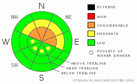
Danger Rose Tutorial
|
At upper elevations dangerous avalanche conditions exist. A Level 3 (CONSIDERABLE) avalanche danger will be found on steep wind drifted slopes, especially those facing the north half of the compass and human triggered avalanches are likely.
At mid elevations a Level 2 (MODERATE) avalanche danger will be found and human triggered avalanches are possible on steep, northerly facing, wind drifted slopes.
Slopes facing the south half of the compass at mid and low elevations and terrain that had no snow prior to the big storm a few weeks ago offer Level 1 (LOW) avalanche danger. |
|
|
CURRENT CONDITIONS |

|
Clear skies and warm air over the Skyline this morning kept temperatures in the mid 20’s. Winds are light and westerly, blowing 5-10 mph even along the high ridges. Two inches of snow fell on Thursday and while it’s not over-the-hood this morning, riding conditions are quite good.
Heads up- a series of storms forecast over the weekend into next week will once again overload the weak snow near the ground. If the weather forecast verifies I expect the avalanche danger to rise accordingly. |
|
|
RECENT ACTIVITY |

|
No new avalanches to report, though we are still discovering more slides from the big storm a few weeks ago! Collapsing continues, especially in terrain where the snowpack remains thin.
Click here for recent observations from the region. |
|
|
THREAT #1 |

|
| WHERE |
PROBABILITY |
SIZE |
TREND |
|
|
|
|
| |
|
|
Over the next
24 hours.
|
|
|
As the storm snow from a few weeks ago gains strength and becomes a cohesive slab, avalanches are becoming more difficult to trigger. However, the slides we do initiate will be deep, wide, and dangerous. It’s a sketchy setup on Skyline and the videos in these two great observations pretty much tell the whole story. (Click here and here).
These are conditions we’re not used to in Utah… they’re more Colorado-esque, where unstable layers of snow near the ground remain suspect for long periods of time. Right now it’s a patience game and for the time being we need to adjust our riding habits to avoid a catastrophic outcome. It doesn’t mean you have to hide under the bed and not ride today. It does mean you need to-
Carefully study the terrain you’re riding today. If it’s upper elevation wind drifted terrain, steeper than 35 degrees, facing the north half of the compass, and didn’t avalanche during the big storm it’s no-go terrain.
The avalanche danger is less pronounced on south facing slopes, low angle meadows and terrain that didn’t have snow prior to the big storm a few weeks ago. |
|
|
MOUNTAIN WEATHER |

|
Clouds increase today and scattered snow showers should develop around lunchtime. Temperatures remain mild with highs in the low 30’s. Southerly winds should stay well behaved averaging 10-15 mph along the ridges. 1”-3” of snow is expected overnight with an additional 3”-7” on Sunday. West and northwest increase into the 20’s Sunday night. A break in the action on Monday with another system slated to effect the region early Tuesday. |
|
|
GENERAL ANNOUNCEMENTS |
The information in this advisory expires 24 hours after the date and time posted, but will be updated by 7:00 AM Sunday, February 12th. If you’re getting out and about and trigger an avalanche or see anything interesting please drop me an email at craig@utahavalanchecenter.org or call 801-231-2170 Also, now is a great time to schedule one of our free avalanche awareness presentations for your group or club. Email or call me and we’ll get you booked before things get too crazy. |
|
|
This information does not apply to developed ski areas or highways where avalanche control is normally done. This advisory is from the U.S.D.A. Forest Service, which is solely responsible for its content. This advisory describes general avalanche conditions and local variations always occur. |
|
This advisory provided by the USDA Forest Service, in partnership with:
The Friends of the Utah Avalanche Center, Utah Division of State Parks and Recreation, Utah Division of Emergency Management, Salt Lake County, Salt Lake Unified Fire Authority and the friends of the La Sal Avalanche Center. See our Sponsors Page for a complete list. |
