SPECIAL ANNOUNCEMENT |
 |
Many thanks to Sterling and everyone from Big Pine along with Arctic Cat for contributing a sweet, new loaner sled to the Avalanche Center again this year… y’all rock!
In addition, huge thanks to everyone who pitched in providing awesome observations this week. Your information helps us produce more accurate advisories, ultimately saving other riders lives! |
|
|
BOTTOM LINE
Danger by aspect and elevation on slopes approaching 35° or steeper.
(click HERE for tomorrow's danger rating)
|

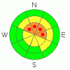
Danger Rose Tutorial
|
At upper elevations dangerous avalanche conditions exist. Pockets of Level 4 (HIGH) avalanche danger will be found on steep wind drifted slopes, especially those facing the north half of the compass and human triggered avalanches are very likely.
A Level 2 (MODERATE) avalanche danger will be found on steep, northerly facing wind drifted slopes at mid elevations and human triggered avalanches are possible.
Slopes that face the south half of the compass and terrain that had no snow prior to last weekends big storm offer a Level 1 (LOW) avalanche danger. |
|
|
CURRENT CONDITIONS |

|
Skies are clear, temperatures in the mid teens and northwesterly winds are blowing 15-25 mph along the ridges. Last weekend’s storm snow has settled and an additional 3”-6” of fresh snow from Thursday provides excellent riding and turning conditions. |
|
|
RECENT ACTIVITY |

|
Yesterday, several human triggered avalanches were reported in steep wind loaded terrain, capping off a very active week on the Skyline where many steep slopes avalanched naturally. In addition, thunderous, booming collapses continue to keep everyone on edge. Click here for recent observations from the region. |
|
|
THREAT #1 |

|
| WHERE |
PROBABILITY |
SIZE |
TREND |
|
|
|
|
| |
|
|
Over the next
24 hours.
|
|
|
The Skyline’s snow structure is some of the weakest any of us have ever seen. Now that last weekend’s big storm snow has settled and gained some strength, it will feel super solid and strong under our skis, board, or sled. The problem is we have strong snow on weak snow and that’s a deceptively dangerous combination. (Click here to view a great video describing what we're dealing with). Further complicating the stability pattern is you can ride plenty of slopes without triggering a slide giving you a false sense of stable snow. However, all you need to do if find a weakness in the snowpack, perhaps around a rock or bush barely buried under the snow surface, collapse the pack, and in an instant, you’re staring down the barrel of a very dangerous slide.
All the signs of unstable snow are screaming at us and you can’t ignore the shooting cracks, loud booming whoomphs, and the hugest to clue to avalanches… recently triggered avalanches!
The consequences of triggering a slide that’s breaks to the ground are catastrophic. However, it doesn’t mean you can’t ride this weekend. As a matter of fact you can have a blast carving turns in a big open meadow and never even have to deal with avalanches. |
|
|
MOUNTAIN WEATHER |

|
High pressure strengthens across the area through the weekend allowing for a warming trend. Today we can expect clear skies with temperatures climbing into the low 30’s before diving back into the teens overnight. Northwest winds will be irritating along the ridges, gusting into the mid 30’s near the high peaks. Slightly warmer on Sunday with the next storm system slated to impact the area on Monday. |
|
|
GENERAL ANNOUNCEMENTS |
The information in this advisory expires 24 hours after the date and time posted, but will be updated by 7:00 AM Saturday, February 4th. If you’re getting out and about and trigger an avalanche or see anything interesting please drop me an email at craig@utahavalanchecenter.org or call 801-231-2170 Also, now is a great time to schedule one of our free avalanche awareness presentations for your group or club. Email or call me and we’ll get you booked before things get too crazy. |
|
|
This information does not apply to developed ski areas or highways where avalanche control is normally done. This advisory is from the U.S.D.A. Forest Service, which is solely responsible for its content. This advisory describes general avalanche conditions and local variations always occur. |
|
This advisory provided by the USDA Forest Service, in partnership with:
The Friends of the Utah Avalanche Center, Utah Division of State Parks and Recreation, Utah Division of Emergency Management, Salt Lake County, Salt Lake Unified Fire Authority and the friends of the La Sal Avalanche Center. See our Sponsors Page for a complete list. |
