AVALANCHE WARNING »
Dangerous avalanche conditions are occuring or are imminent.
Backcountry travel in avalanche terrain is not recommended.
|
 |
Notice: An Avalanche Warning has been issued for the Manti-Skyline. Strong winds, coupled with dense, heavy snow, falling on a historically weak snowpack has created a HIGH avalanche danger and human triggered avalanches are very likely. Backcountry travel is not recommended. |
|
|
BOTTOM LINE
Danger by aspect and elevation on slopes approaching 35° or steeper.
(click HERE for tomorrow's danger rating)
|
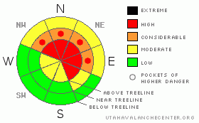
Danger Rose Tutorial
|
At upper elevations dangerous avalanche conditions exist. A Level 4 (HIGH) avalanche danger will be found on steep wind drifted slopes, especially those facing the north half of the compass and human triggered avalanches are very likely.
Steep, mid and lower elevation slopes harbor very weak snow. In steep northerly facing terrain a Level 3 (CONSIDERABLE) danger exists and human triggered avalanches are likely.
At lower elevations and on slopes that face the south half of the compass that had no snow prior to this storm, you’ll find a Level 1 (LOW) avalanche danger. |
|
|
CURRENT CONDITIONS |

|
Light snow is just starting to fall, temperatures are in the mid 30's, and southwest winds are cranking in the 30's and 40's along the high ridges. |
|
|
RECENT ACTIVITY |

|
Darce and Steve experienced an active day on the Skyline with plenty of collapasing and whoomphing, shooting cracks, and an avalanche triggered on GE Hill. Click here for their trip report.
Check out Matt's great observation in lower elevation terrain of Fairview Canyon... thanks man!
Click here for recent observations from the region. |
|
|
THREAT #1 |

|
| WHERE |
PROBABILITY |
SIZE |
TREND |

|
|
|
|
| |
|
|
Over the next
24 hours.
|
|
|
The Skyline snowpack is shallow, weak, and sugary. Not exactly the building blocks you want for a bomber snowpack. As a matter of fact, this is some of the weakest snow any of us have ever seen. What's been lacking for most of the winter is a slab. Now the winds are cranking, there's a storm headed our way, and a thick cohesive piece of snow has formed on top of this structurally challenged junk show. Avalanche conditions are downright dangerous and this weekend you need to stay off of and out from under any steep wind drifted slope. Remember- look for clues to unstable snow like cracking, whoomphing noises, and of course the biggest clue to avalanches..... avalanches on the same kinds of slopes we wanna ride on. Lower elevations don't offer much relief from the sketchy avalanche conditions. They're collapsing and shattering too. Check out this observation from around Electric Lake.
I know it doesn't seem like there's enough snow to avalanche, but these are exactly the kind of conditions when even very experienced backcountry riders get caught, injured, or killed.... yes it's that sketchy out there.
It doesn't mean you can't ride today. You can have a blast carving on a sled in a big meadow with no steep slopes above or adjacent to where you're riding. If you're out on the kite-board, skis, or board you can head to mid and low elevation terrain that was bare ground prior to the storm. In any case, even if you're riding on low angle terrain steer clear of terrain where steep slopes are above and adjacent to where you're riding. |
|
|
MOUNTAIN WEATHER |

|
Strong west and southwest winds are on tap as a powerful winter storms slams into the region. Winds will gust into the 40's and 50's with higher gusts along the exposed ridges. 3"-5" of snow is expected today and temperatures remain mild with highs in the mid to upper 30's before diving into the low 20's overnight as the cold front reaches the region. An additional 4"-8" of snow is expected tonight before we see a break in the action for Sunday. Another system is slated for Monday. |
|
|
GENERAL ANNOUNCEMENTS |
The information in this advisory expires 24 hours after the date and time posted, but will be updated by 7:00 AM Sunday, January 22nd. If you’re getting out and about and trigger an avalanche or see anything interesting please drop me an email at craig@utahavalanchecenter.org or call 801-231-2170 Also, now is a great time to schedule one of our free avalanche awareness presentations for your group or club. Email or call me and we’ll get you booked before things get too crazy. |
|
|
This information does not apply to developed ski areas or highways where avalanche control is normally done. This advisory is from the U.S.D.A. Forest Service, which is solely responsible for its content. This advisory describes general avalanche conditions and local variations always occur. |
|
This advisory provided by the USDA Forest Service, in partnership with:
The Friends of the Utah Avalanche Center, Utah Division of State Parks and Recreation, Utah Division of Emergency Management, Salt Lake County, Salt Lake Unified Fire Authority and the friends of the La Sal Avalanche Center. See our Sponsors Page for a complete list. |
