SPECIAL ANNOUNCEMENT |
 |
Heads up…. a weather pattern change is slated for the latter half of next week. If the forecast verifies, avalanche conditions will change dramatically. |
|
|
BOTTOM LINE
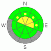
Danger by aspect and elevation on slopes approaching 35° or steeper.
(click HERE for tomorrow's danger rating)
|
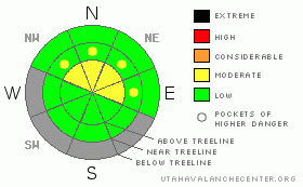
Danger Rose Tutorial
|
On steep, mid and upper elevation wind drifted slopes where strong snow overlays weak sugary snow, a Level 2 (MODERATE) avalanche danger exists and human triggered avalanches breaking to weak snow near the ground are possible.
Elsewhere the avalanche danger is generally Level 1 (LOW) |
|
|
CURRENT CONDITIONS |

|
Under clear skies temperatures remained rather balmy overnight. Currently it’s in the low to mid 20’s. West and northwest winds are blowing 10-20 mph along the ridges. It's pretty grim out there, but riding and turning conditions aren’t bad for early October. |
|
|
RECENT ACTIVITY |

|
Darce and Steve traveled in Bulger Canyon yesterday and found good turns despite the overall lack of snow. Click here for their trip report.
Click here for recent observations from the region. |
|
|
THREAT #1 |

|
| WHERE |
PROBABILITY |
SIZE |
TREND |
|
|
|
|
| |
|
|
Over the next
24 hours.
|
|
|
It’s a complete junk show out there comprised of very weak sugary snow near the ground, supportable and unsupportable wind slabs, and of course bare ground. What a way to run a winter! It’s mid January and our total snow depths only average 12”- 18”. What this means is a structurally challenged snowpack that has no strength and will surely come unglued once it starts storming again. For the moment the most likely place to trigger an avalanche is going to be at upper elevations where the wind has formed a strong slab which rests on top of weak snow. Problem is…. this combination feels solid underneath our skis, board, or sled. It lures us well out onto the slope before failing, then takes you for a body beating ride through trees, stumps, and rocks. At the very least you’ll be looking at a season ending injury. You can however, avoid messing around with avalanches and still have a blast on low angle terrain which is sheltered from the wind. No, it’s not the epic conditions we’re used to, but it’s a long season and it does look like a change in the weather pattern is just a few days away. |
|
|
MOUNTAIN WEATHER |

|
A beautiful sunny day is on tap with temperatures climbing into the low 40’s. Overnight lows dip into the 20’s and southwest winds increase as well. Partly cloudy skies with gusty winds usher in a quick hitting storm which should slide through the region late Sunday with 2”-5” expected. A break in the action for early in the week and then a moist westerly flow develops Wednesday through Friday. This could mean a significant pattern change for us with strong winds and accumulating snow. |
|
|
GENERAL ANNOUNCEMENTS |
The information in this advisory expires 24 hours after the date and time posted, but will be updated by 7:00 AM Saturday, January 21st.
If you’re getting out and about and trigger an avalanche or see anything interesting please drop me an email at craig@utahavalanchecenter.org or call 801-231-2170.
Also, now is a great time to schedule one of our free avalanche awareness presentations for your group or club. Email or call me and we’ll get you booked before things get too crazy. |
|
|
This information does not apply to developed ski areas or highways where avalanche control is normally done. This advisory is from the U.S.D.A. Forest Service, which is solely responsible for its content. This advisory describes general avalanche conditions and local variations always occur. |
|
This advisory provided by the USDA Forest Service, in partnership with:
The Friends of the Utah Avalanche Center, Utah Division of State Parks and Recreation, Utah Division of Emergency Management, Salt Lake County, Salt Lake Unified Fire Authority and the friends of the La Sal Avalanche Center. See our Sponsors Page for a complete list. |
