BOTTOM LINE
Danger by aspect and elevation on slopes approaching 35° or steeper.
(click HERE for tomorrow's danger rating)
|

Danger Rose Tutorial
|
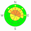
In steep mid and upper elevation terrain avalanche conditions are deceptively tricky. On any steep slope facing the north half of the compass you'll find a Level 3 (Considerable) avalanche danger and human triggered avalanches are likely.
At lower elevations and on mid elevation slopes that face the south half of the compass, you’ll find a Level 1 (LOW) avalanche danger. |
|
|
CURRENT CONDITIONS |

|
Light snow is falling, west and northwest winds are blowing 10-20 mph along the ridges, and temperatures are in the mid to upper 20’s. The snow surface is a mixed bag ranging from wind board, to facets on facets, to just plain dirt. Riding and turning conditions are grim at best…. but there’s s glimmer of hope with today’s expected storm. |
|
|
RECENT ACTIVITY |

|
The region experienced a pockety natural avalanche cycle after the New Years wind event. Darce and Steve were out and about Friday and amongst the downed timber and occasional rock shot found some soft settled snow in mid elevation wind sheltered terrain. Click here for their insightful trip report and to view recent avalanche pictures.
Click here for recent observations from the region. |
|
|
THREAT #1 |

|
| WHERE |
PROBABILITY |
SIZE |
TREND |
|
|
|
|
| |
|
|
Over the next
48 hours.
|
|
|
A decent shot of snow is headed our way and avalanche conditions will start to deteriorate in a hurry today. The new snow is manageable and will break around or below our skis, board, or sled predictably sliding on the hard surface formed by last weekend’s raging hurricane force winds. But that’s not the problem. The problem is all the weak snow that’s underneath this strong, solid feeling slab. Remember, strong snow on weak snow is a bad combination and most of the mid and upper elevation northerly facing terrain surrounding the Skyline has this very deceptively, tricky setup. Once triggered, avalanches can break wide and deep, failing on weak sugary snow near the ground, taking out the entire season’s snowpack. If you’re looking for safe terrain to ride, stick with low angle meadows with no steep slopes above or adjacent to where you’re riding or head to south facing terrain. |
|
|
MOUNTAIN WEATHER |

|
A good shot of snow is headed our way and we should see 5”-10”before the storm exits the region and high pressure begins to build on Sunday. West and northwest winds will gust into the 30’s and 40’s this morning as the cold front arrives. We’ve already reached our high temperatures for the day and overnight lows will dip into the lower teens. Sunny and warmer weather is on tap for Sunday and Monday with a weak system grazing the region midweek. After that high pressure builds. |
|
|
GENERAL ANNOUNCEMENTS |
The information in this advisory expires 24 hours after the date and time posted, but will be updated by 7:00 AM Saturday, January 14th. If you’re getting out and about and trigger an avalanche or see anything interesting please drop me an email at craig@utahavalanchecenter.org or call 801-231-2170 Also, now is a great time to schedule one of our free avalanche awareness presentations for your group or club. Email or call me and we’ll get you booked before things get too crazy. |
|
|
This information does not apply to developed ski areas or highways where avalanche control is normally done. This advisory is from the U.S.D.A. Forest Service, which is solely responsible for its content. This advisory describes general avalanche conditions and local variations always occur. |
|
This advisory provided by the USDA Forest Service, in partnership with:
The Friends of the Utah Avalanche Center, Utah Division of State Parks and Recreation, Utah Division of Emergency Management, Salt Lake County, Salt Lake Unified Fire Authority and the friends of the La Sal Avalanche Center. See our Sponsors Page for a complete list. |
