SPECIAL ANNOUNCEMENT |
 |
Dispelling any myths, rumors, or conspiracy theories the Manti-Skyline avalanche advisory will be in full swing this season and we plan on issuing updates each Saturday morning. Unfortunately, our main man Grant Helgeson was offered a job with the Canadian Avalanche Center and has moved in that direction. However, the Salt Lake forecasting staff is stepping up to the task, filling the enormous shoes Grant left behind… man that’s gonna be a tough one! With that in mind we need your help more than ever before. Your observations- snowpack, weather, avalanche, or just plain riding conditions are crucial to the success of this program and will help keep other riders alive! Please tell us what you’re seeing so we can provide the most accurate information. If you see or trigger an avalanche you can reach me craig@utahavalanchecenter.org or call 801-231-2170 or better yet, follow the links here to post your own observations.
Save the date and take a date. Join us and the athletes from Boondockers for a movie night on Thursday Dec. 1st, 7:00 PM at the North Sanpete High School Auditorium on 400E 700S in Mt Pleasant. We’ve got great raffle prizes and a ton of swag to give away! All proceeds go to your local avalanche advisory and outreach program.
Cost: $5 per adult / $2 per child under 12. Each person gets 1 raffle ticket with the entrance fee. Additional raffle tickets will be for sale. |
|
|
BOTTOM LINE
Danger by aspect and elevation on slopes approaching 35° or steeper.
(click HERE for tomorrow's danger rating)
|
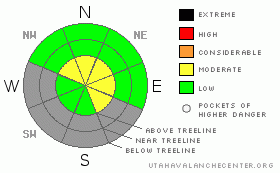
Danger Rose Tutorial
|
This weekend you’ll find a Level 2 (Moderate) avalanche danger in steep, upper elevation wind drifted terrain and human triggered avalanches are possible. Avalanches triggered within the new storm snow have the possibility of breaking into weaker snow near the ground, especially in steep, rocky terrain, producing a larger slide than you might have bargained for.
A Level 1 (Low) avalanche danger will be found at lower elevations out of the wind, on southerly facing terrain, and on slopes that had no snow prior to last weekend’s big storm. |
|
|
CURRENT CONDITIONS |

|
Under mostly cloudy skies, light snow is falling and temperatures are in the upper teens and low 20’s. New snow totals from last nights system aren’t all that impressive with just 4” on the north side of the range and closer to 7” in the heart of our terrain. Of course winds are the great equalizer on the Skyline and during this storm they didn’t disappoint. South, southwest, west and now northwesterly winds have been cranking into the 40’s and 50’s along the high ridges.
The mountains may be white from far, but they’re far from white. Most mid and lower elevation slopes have just a few inches of new snow from last nights storm and average snow depths at the upper elevations are meager at best with totals closer to two feet. If you’re itching to get out and ride, rock free roads and grassy meadows are your best bet. |
|
|
RECENT ACTIVITY |

|
The Skyline experienced a widespread avalanche cycle last weekend with many steep slopes throughout range avalanching naturally, breaking near the ground. One human triggered slide down canyon of the Big Drift was reported and is a real eye opener. Click here for this great observation by Sean. |
|
|
THREAT #1 |

|
| WHERE |
PROBABILITY |
SIZE |
TREND |
|
|
|
|
| |
|
|
Over the next
24 hours.
|
|
|
It might not seem like there’s that much snow in our neck of the woods. However, if there’s enough snow to ride…. there’s enough snow to slide. (Click here for Darce and Steve's great recap of yesterday’s conditions). The good news is the avalanche danger is confined to steep, wind drifted, upper elevation slopes facing the north half of the compass. The bad news is these are going to be exactly the types of slopes we head to because they’re holding snow. While manageable in size to begin with, once triggered, even a small slide will get quickly out of hand. While more the exception than the rule be aware- avalanches triggered today can break into older sugary snow near the ground, uncovering rocks and stumps barely hidden under this façade of snow. If you get caught in an avalanche this weekend a season ending injury is almost guaranteed. That doesn’t mean you can’t go out and ride today, but it does mean that you need to be aware of the consequences. Your best bet is to exercise some patience, stick with low angle, rock free terrain and remember... it’s a long winter and there’s plenty of epic days to be had. |
|
|
MOUNTAIN WEATHER |

|
A few lingering snow showers should affect the region with an additional inch or two expected before the storm moves to the east and skies begin to clear. Northwesterly winds will gust into the 30’s and 40’s along the high ridges. Temperatures reach into the mid 20’s and low 30’s before bottoming out into the teens overnight. A weak system moves through the region on Sunday and Monday with high pressure building for mid week. A chance of a good storm looks promising for Thanksgiving. |
|
|
GENERAL ANNOUNCEMENTS |
The information in this advisory expires 24 hours after the date and time posted, but will be updated by 7:00 AM Saturday, November 26th. If you’re getting out and about and trigger an avalanche or see anything interesting please drop me an email at craig@utahavalanchecenter.org or call 801-231-2170 Also, now is a great time to schedule one of our free avalanche awareness presentations for your group or club. Email or call me and we’ll get you booked before things get too crazy. |
|
|
This information does not apply to developed ski areas or highways where avalanche control is normally done. This advisory is from the U.S.D.A. Forest Service, which is solely responsible for its content. This advisory describes general avalanche conditions and local variations always occur. |
|
This advisory provided by the USDA Forest Service, in partnership with:
The Friends of the Utah Avalanche Center, Utah Division of State Parks and Recreation, Utah Division of Emergency Management, Salt Lake County, Salt Lake Unified Fire Authority and the friends of the La Sal Avalanche Center. See our Sponsors Page for a complete list. |
