BOTTOM LINE
Danger by aspect and elevation on slopes approaching 35° or steeper.
(click HERE for tomorrow's danger rating)
|
Danger Rose Tutorial
|
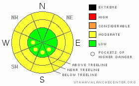
A Level 2 (Moderate) avalanche hazard exists today. Daytime heating will kickstart a round of wet avalanches failing in the new snow. Avoid terrain traps such as steep gulley features where these long running wet sluffs could entrain enough snow to bury a person. |
|
|
CURRENT CONDITIONS |

|
Temperatures climbed into the mid 40’s at upper elevations mid-week, capping all aspects and elevations with a melt freeze crust of varying strength. Early Thursday morning 3" of snow fell on top of this crust. Unfortunately, riding conditions are marginal at best. Temps are currently in the teens at upper elevations & winds are light out of the south. |
|
|
RECENT ACTIVITY |

|
No recent activity reported or observed. |
|
|
THREAT #1 |

|
| WHERE |
PROBABILITY |
SIZE |
TREND |

|
|
|
|
| |
|
|
Over the next
24 hours.
|
|
|
Today will be a beautiful day in the mountains under mostly sunny skies. Temperatures will once again climb above freezing and the new snow will be sensitive to the heat. I expect the new snow to fail in long running "wet sluffs." These avalanches will start small and entrain more snow as they move down the mountain. Terrain features like steep gulleys will pose the most hazard, as these kinds of features are particularly good at funneling snow. With the exception of creek bottoms & steep gulley features, this should be a very manageable hazard for riders today.
There's a general rule of thumb we can use as riders when conditions are dominated by melt freeze cycles. With a good overnight re-freeze the snowpack tightens up and is generally good to go so long as it's supporting us & the weight of our machines. But, once it starts to loosen up under the strong mid-day sun, the melt/freeze snow looses a lot of strength. When you feel yourself or your machine starting to sink deeper into the snow, it's time to call it a day. This indicates that the sloppy & wet snowpack has lost its overnight strength and it's time to get off the slopes. |
|
|
MOUNTAIN WEATHER |

|
Today we're expecting mostly sunny skies while temperatures climb into the high 30's at upper elevations. Winds will begin to ramp up this afternoon, topping out around 35 mph at ridge top. Temperatures retreat below freezing this evening before climbing again tomorrow. Saturday looks to be another warm day in the mountains with a high near 40°. Expect Saturday to be a bit blustery, sustained 30 mph winds out of the south are expected with gusts as high as 50 mph at ridgetop. A weak disturbance crosses over the region Saturday night & Sunday, but only a few inches of total snowfall are expected. |
|
|
GENERAL ANNOUNCEMENTS |
See or trigger an avalanche? I'd like to hear about it! You can reach me on my cell phone: 801-824-0305 or shoot me an email: grant (at) utahavalanchecenter (dot) org Observers may choose to remain anonymous if they wish. |
|
|
This information does not apply to developed ski areas or highways where avalanche control is normally done. This advisory is from the U.S.D.A. Forest Service, which is solely responsible for its content. This advisory describes general avalanche conditions and local variations always occur. |
|
This advisory provided by the USDA Forest Service, in partnership with:
The Friends of the Utah Avalanche Center, Utah Division of State Parks and Recreation, Utah Division of Emergency Management, Salt Lake County, Salt Lake Unified Fire Authority and the friends of the La Sal Avalanche Center. See our Sponsors Page for a complete list. |
