BOTTOM LINE
Danger by aspect and elevation on slopes approaching 35° or steeper.
(click HERE for tomorrow's danger rating)
|
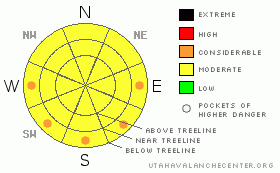
Danger Rose Tutorial
|
There is a Level 2 (Moderate) avalanche danger on slopes getting baked in the strong afternoon sun. Stay off of and out from underneath these slopes as they loosen up after lunch. There is also a Level 2 (Moderate) avalanche hazard associated with both lingering deep slabs and isolated wind slabs. All of these hazards are easily managed by choosing more conservative terrain. |
|
|
CURRENT CONDITIONS |

|
Riding conditions are currently a bit of a mixed bag. The sun crust is dominant at mid & lower elevations on all aspects aside from N & NE. The big open bowls are wind damaged & slabby. The best riding is on protected high elevation N facing trees where you can still find some settled powder.
It's pretty warm this morning, the stations are reading just below freezing even near 10,000'. Winds are light out of the SW. |
|
|
RECENT ACTIVITY |

|
Looks like there was a widespread avalanche cycle within the 10" of storm snow we picked up earlier this week. I was still able to intentionally trigger small slab avalanches on convex rollers in Seeley Creek yesterday too. |
|
|
THREAT #1 |

|
| WHERE |
PROBABILITY |
SIZE |
TREND |
|
|
|
|
| |
|
|
Over the next
24 hours.
|
|
|
It's looking like it will be another warm afternoon in the mountains, with high elevation temps expected to reach into the 40's. The 10" of storm snow we received earlier this week will be susceptible to the warming first forming roller balls then progressing into wet sluffs and slabs. This will be a concern, especially on slopes that face the south half of the compass at mid & lower elevations. This hazard is easily avoided by staying off of and away from slopes that are getting damp in the strong afternoon sun. |
|
|
THREAT #2 |

|
| WHERE |
PROBABILITY |
SIZE |
TREND |

|
|
|
|
| |
|
|
Over the next
24 hours.
|
|
|
After all the great powder riding over the last two weeks, it's easy to forget about the old rain crust, now buried 3' below the snow surface, but, the snowpack has the memory of an elephant, and it won't soon forget. In our tests, this layer is still reactive to a hard trigger, meaning it takes a sizeable load to get it going, something like a large cornice fall or a snowmobile jumping off said cornice. These long hot afternoons have the potential to irritate this buried weakness too. If triggered, an avalanche failing around the rain crust has the potential to be large & destructive. So, I'm still a bit hesitant to get into the big open terrain that faces the north through east sides of the compass. |
|
|
THREAT #3 |

|
| WHERE |
PROBABILITY |
SIZE |
TREND |

|
|
|
|
| |
|
|
Over the next
24 hours.
|
|
|
While the wind slabs are almost a thing of the past, there are still isolated pockets of touchy wind slab on high elevation north facing slopes, the same places where the best riding is today. These are limited to the recent storm snow (10") and are failing as a soft slab. You're most likely to trigger these where it's steep, especially if a convex roller is involved. While these small avalanches are mostly manageable, be careful that one doesn't knock you off your intended line. |
|
|
MOUNTAIN WEATHER |

|
The Seeley Creek Wx station at 10,000' is already reading 32.2° at 6:45 this morning. Needless to say, it's going to be another warm day in the mountains. Temperatures are forecasted to reach into the 40's this afternoon at upper elevations. Saturday will dawn clear before a small disturbance crosses the area in the afternoon. No significant snow/precip is expected. Sunday will be another scorcher under mostly sunny skies with temps again reaching into the 40's up high. |
|
|
GENERAL ANNOUNCEMENTS |
See or trigger an avalanche? I'd like to hear about it! You can reach me on my cell phone: 801-824-0305 or shoot me an email: grant (at) utahavalanchecenter (dot) org Observers may choose to remain anonymous if they wish. |
|
|
This information does not apply to developed ski areas or highways where avalanche control is normally done. This advisory is from the U.S.D.A. Forest Service, which is solely responsible for its content. This advisory describes general avalanche conditions and local variations always occur. |
|
This advisory provided by the USDA Forest Service, in partnership with:
The Friends of the Utah Avalanche Center, Utah Division of State Parks and Recreation, Utah Division of Emergency Management, Salt Lake County, Salt Lake Unified Fire Authority and the friends of the La Sal Avalanche Center. See our Sponsors Page for a complete list. |
