BOTTOM LINE
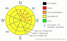
Danger by aspect and elevation on slopes approaching 35° or steeper.
(click HERE for tomorrow's danger rating)
|
Danger Rose Tutorial
|
We have pockets of a LEVEL 3 (CONSIDERABLE) avalanche danger for triggering a deep slab avalanche on mid and upper elevation north through east facing terrain. While the chances for triggering one are low, the consequences if you do are high. Also, watch for fresh drifts and try to prod them on test slopes to see how reactive they are before getting onto more serious terrain. |
|
|
CURRENT CONDITIONS |

|
Wow!! What an unexpected treat on the Skyline Thursday!! 8-10 inches of new snow fell in the high country. You’ll find it’s settled to around 6 inches. Winds have slowed a little and are from the west. Temperatures are in the teens. |
|
|
RECENT ACTIVITY |

|
Poor visibility prevented me from getting into the upper terrain but from what I found the newest snow did not seem particularly reactive. I suspect that during the peak of the snowfall there was some instability. Looking back over the past week, there was natural activity with last weekends storm within the new snow. (DETAILS) We haven’t heard of any avalanches breaking into deeper layers. |
|
|
THREAT #1 |

|
| WHERE |
PROBABILITY |
SIZE |
TREND |
|
|
|
|
| |
|
|
Over the next
24
hours.
|
|
|
Triggering a deep slab avalanche remains the most dangerous thing out there right now. I think that most slopes won’t avalanche but I do think there’s still a possibility and the recent addition of new snow will have upped the chances a bit. This makes it tricky in that you might get away with numerous steep slopes only to have one release after not expecting it. Digging into the snowpack I found weak snow that no doubt showed signs that it could avalanche. (DETAILS) Weak snow around the January rain crust is the culprit. It seems more pronounced in areas with a shallower depth in the 70 inch total depth range. I’d be wary of the mid and upper elevation north through east facing terrain this weekend. |
|
|
THREAT #2 |

|
| WHERE |
PROBABILITY |
SIZE |
TREND |

|
|
|
|
| |
|
|
Over the next
24
hours.
|
|
|
As is often the case, fresh drifts form along the ridges during storms. These were most sensitive on Thursday but you still may find some of these to crack out. Upper elevation northeast through southeast aspects are most likely. |
|
|
MOUNTAIN WEATHER |

|
Looks like we’ll have a pretty nice day today with partly cloudy skies and temperatures in the upper 20s. Winds should be light to moderate from the northwest. Temperatures increase a bit Saturday with partly cloudy skies and more clouds with the chance for light snow on Sunday and mild temperatures. A better chance for snow looks like it may happen early next week. |
|
|
GENERAL ANNOUNCEMENTS |
See or trigger an avalanche? I'd like to hear about it! You can reach me on my cell phone: 801-231-4744 or shoot me an email: grant (at) utahavalanchecenter (dot) org Observers may choose to remain anonymous if they wish.
Click here for a refresher on the Avalanche Danger Scale.
Click here for a review on the Danger Rose. |
|
|
This information does not apply to developed ski areas or highways where avalanche control is normally done. This advisory is from the U.S.D.A. Forest Service, which is solely responsible for its content. This advisory describes general avalanche conditions and local variations always occur. |
|
This advisory provided by the USDA Forest Service, in partnership with:
The Friends of the Utah Avalanche Center, Utah Division of State Parks and Recreation, Utah Division of Emergency Management, Salt Lake County, Salt Lake Unified Fire Authority and the friends of the La Sal Avalanche Center. See our Sponsors Page for a complete list. |
