AVALANCHE WARNING »
Dangerous avalanche conditions are occuring or are imminent.
Backcountry travel in avalanche terrain is not recommended.
|
 |
Notice: An avalanche warning is in effect for most of the mountains of Utah including the Manti Skyline. Very strong winds Friday afternoon and overnight combined with a foot of new snow (and more to come) have created a HIGH avalanche danger on many slopes. Stay off of and out from underneath slopes steeper than 30 degrees for the weekend. |
|
|
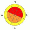
BOTTOM LINE
Danger by aspect and elevation on slopes approaching 35° or steeper.
(click HERE for tomorrow's danger rating)
|

Danger Rose Tutorial
|
There is a HIGH (Level 4) avalanche danger on any slope of 30 degrees or steeper, especially on slopes with recent wind deposits. Stay off of and out from underneath steep slopes this weekend. This includes terrain traps such as gullies. This is a good weekend to cool it and stay on gentle terrain. |
|
|
CURRENT CONDITIONS |

|
I'm filling in for the intrepid Grant Helgeson today as he is getting his Level 2 professional avalanche certification in Canada this week.
The skyline is up to about a foot of new snow with about 8 more inches expected today. But the winds are the big story. Very strong winds from the southwest blew yesterday and overnight, which created widespread areas of wind slabs on lee terrain as well as "upside down" punchy snow on all slopes. |
|
|
RECENT ACTIVITY |

|
Steve Cote sent an excellent report from Friday in the Miller's Flat area. Although the wind and poor visibility prevented most people from getting out and seeing avalanches, you can be certain there are many natural avalanches and many just waiting for a trigger such as the weight of a person or snowmobile.
Click HERE for other observations from the Skyline. |
|
|
THREAT #1 |

|
| WHERE |
PROBABILITY |
SIZE |
TREND |
|
|
|
|
| |
|
|
Over the next
24
hours.
|
|
|
Very strong winds from the southwest drifted the new snow onto downwind terrain and created widespread areas of dangerous wind slabs. As always, you must avoid any slope 30 degrees or steeper with recent deposits of wind drifted snow and avoid crossing beneath them. Wind slabs look smooth and rounded and they feel punchy. But there is a layer of "sucker snow" on top of all the dangerous wind drifts. So don't be fooled by the lighter snow on the surface, which hides the dangerous wind drifts underneath.
This is a good weekend to stay on gentle terrain. It's easy for snowmobilers to play on gentle terrain but harder for skiers and snowboarders. So be careful about the temptation of steeper slopes. |
|
|
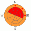
THREAT #2 |

|
| WHERE |
PROBABILITY |
SIZE |
TREND |
|
|
|
|
| |
|
|
Over the next
24
hours.
|
|
|
With new snow and wind, many of the wind slab avalanches may break deeper into old snow to buried, persistent weak layers, making a larger and more dangerous avalanche. The old rain crust has weak, faceted snow growing both on top of and underneath the crust and these persistent weak layers are notorious because they continue to produce avalanches several days after the storm. |
|
|
MOUNTAIN WEATHER |

|
The cold front will push across central Utah this morning bringing perhaps 8 more inches of snow and the winds should drop. We should get just light snow showers this afternoon and evening. Temperatures should be in the mid 20's today but drop into the mid teens tonight.
On Sunday, the winds will pick up and blow harder again, but this time from the northwest, which will create some wind drifts on a whole new set of slopes--slopes facing southwest and cross loaded into other slopes as well. |
|
|
GENERAL ANNOUNCEMENTS |
See or trigger an avalanche? I'd like to hear about it! You can reach me on my cell phone: 801-231-4744 or shoot me an email: bruce (at) utahavalanchecenter (dot) org Observers may choose to remain anonymous if they wish.
Click here for a refresher on the Avalanche Danger Scale.
Click here for a review on the Danger Rose. |
|
|
This information does not apply to developed ski areas or highways where avalanche control is normally done. This advisory is from the U.S.D.A. Forest Service, which is solely responsible for its content. This advisory describes general avalanche conditions and local variations always occur. |
|
This advisory provided by the USDA Forest Service, in partnership with:
The Friends of the Utah Avalanche Center, Utah Division of State Parks and Recreation, Utah Division of Emergency Management, Salt Lake County, Salt Lake Unified Fire Authority and the friends of the La Sal Avalanche Center. See our Sponsors Page for a complete list. |
