AVALANCHE WATCH »
The risk of an avalanche is expected to increase significantly
but the timing and location are still uncertain. Stay tuned for updates.
|
 |
Notice: We have issued an Avalanche Watch for the Manti Skyline for Friday and will likely go to an Avalanche Warning for Saturday and Sunday. An Avalanche Watch means that we expect the avalanche danger to rise to an unusually dangerous level in the next day or so. |
|
|
BOTTOM LINE
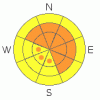
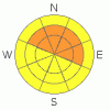
Danger by aspect and elevation on slopes approaching 35° or steeper.
(click HERE for tomorrow's danger rating)
|
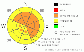
Danger Rose Tutorial
|
There is a Considerable (Level 3) avalanche danger on any slope approaching 35 degrees or steeper with recent wind deposits and also a Level 3 danger on slopes that face generally north or east. Expect the avalanche danger to rise to High (Level 4) this weekend. This is a good weekend to stay off of steep slopes and out from underneath them, and stay well back from cornices. We will likely issue an Avalanche Warning for the weekend. |
|
|
CURRENT CONDITIONS |

|
I'm filling in for the intrepid Grant Helgeson today as he is attending avalanche training in Canada this week.
5 inches of new snow fell at the Mammoth Cottonwood station and I expect another 3 inches today. Heavier snow is forecast for Saturday. Ridge top winds are blowing 30 mph from the west and southwest and temperatures are 22 degrees. |
|
|
RECENT ACTIVITY |

|
Steve Cote will likely be out doing field work today on the Skyline and I will update this report tonight or tomorrow morning. In the mean time, you can click HERE to read all the observations from the past week or more.
We have not heard about any activity from the Skyline yesterday but an avalanche was triggered on Tuesday (report with photos) on GE Hill. From the photos it looks like it was a wind slab on top of the old, hard snow. I would not be surprised if there was some surface hoar or faceted snow as the weak layer. |
|
|
THREAT #1 |

|
| WHERE |
PROBABILITY |
SIZE |
TREND |
|
|
|
|
| |
|
|
Over the next
24
hours.
|
|
|
As snow piles up today, and especially on Saturday, expect fresh wind slabs to build on all the upper elevation, wind exposed terrain. As always, you should avoid any slope approaching 35 degrees or steeper with recent deposits of wind drifted snow. Expect the danger to rise to HIGH on Saturday. |
|
|
THREAT #2 |

|
| WHERE |
PROBABILITY |
SIZE |
TREND |
|
|
|
|
| |
|
|
Over the next
24
hours.
|
|
|
Although the pre-existing snow is fairly stable on the Skyline from what we are used to, there are a number of slopes with buried, persistent weak layers, especially in places with a thin snowpack. As new snow piles up, and especially wind deposited snow, expect some of these deeper layers to be reactivated. These are stubborn to trigger, but if you do trigger one, it will create a large and dangerous avalanche. This is a good weekend to stay on gentler terrain. |
|
|
MOUNTAIN WEATHER |

|
This is a complex storm so we're less confident of the forecast but here's my best guess.
Winds will continue strong from the southwest today through Saturday blowing 30, gusting to 40. We should get perhaps a foot of snow on Saturday as the cold front pushes across and the winds should drop by Saturday night. Ridge top temperatures will be in the mid 20's today but drop into the teens on Saturday night.
On Sunday, snow should taper off but the winds should pick up again and blow from the northwest around 25 mph gusting to 35. Storm totals will likely be 1.5 to 2 feet of snow with lots of wind drifting. |
|
|
GENERAL ANNOUNCEMENTS |
See or trigger an avalanche? I'd like to hear about it! You can reach me on my cell phone: 801-231-4744 or shoot me an email: bruce (at) utahavalanchecenter (dot) org Observers may choose to remain anonymous if they wish.
Click here for a refresher on the Avalanche Danger Scale.
Click here for a review on the Danger Rose. |
|
|
This information does not apply to developed ski areas or highways where avalanche control is normally done. This advisory is from the U.S.D.A. Forest Service, which is solely responsible for its content. This advisory describes general avalanche conditions and local variations always occur. |
|
This advisory provided by the USDA Forest Service, in partnership with:
The Friends of the Utah Avalanche Center, Utah Division of State Parks and Recreation, Utah Division of Emergency Management, Salt Lake County, Salt Lake Unified Fire Authority and the friends of the La Sal Avalanche Center. See our Sponsors Page for a complete list. |
