AVALANCHE WARNING »
Dangerous avalanche conditions are occuring or are imminent.
Backcountry travel in avalanche terrain is not recommended.
|
 |
Notice: Special Update: Sunday Feb. 20, 0730
A NATURAL AVALANCHE CYCLE IS IN PROGRESS. LARGE AMOUNTS OF NEW SNOW WITH WIND HAS CREATED A HIGH AVALANCHE DANGER. PEOPLE SHOULD AVOID ANY STEEP MOUNTAINOUS SLOPES TODAY AND INTO MONDAY. WITH THE WEATHER CLEARING SOMEWHAT ON MONDAY AND LINGERING UNSTABLE SNOW, THE BUSY HOLIDAY IS RIPE FOR AN AVALANCHE ACCIDENT. |
|
|
SPECIAL ANNOUNCEMENT |
 |
Our fourth annual Avy Ride, a fundraiser benefitting avalanche outreach and education specifically for snowmobilers, will be held Saturday Feb. 26th. We’re still working some elements out on our website, but you can get more details by clicking here. |
|
|
BOTTOM LINE
Danger by aspect and elevation on slopes approaching 35° or steeper.
(click HERE for tomorrow's danger rating)
|
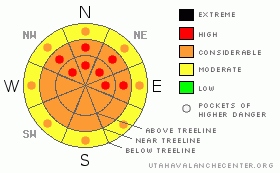
Danger Rose Tutorial
|
The avalanche danger is at Level 4 (HIGH) especially in areas that have received more than 6 inches of snow which are in wind effected terrain. This is most pronounced on the mid and upper elevation slopes of 30 degrees or steeper on the north half of the compass. People without excellent snow assessment skills should avoid all steep slopes today. |
|
|
CURRENT CONDITIONS |

|
12" of new snow feel in the wee hours of Thursday morning. Riding conditions are currently excellent & the new snow is bonding well to the old snow surface. Temperatures average 21 F this morning & winds are light out of the SW @ 6mph. |
|
|
RECENT ACTIVITY |

|
Yesterday I tweaked small test slopes all day long. The only reaction I could get out of the snowpack were long running loose snow avalanches (sluffs) in the new snow. No other avalanche activity was reported or observed. |
|
|
THREAT #1 |

|
| WHERE |
PROBABILITY |
SIZE |
TREND |
|
|
|
|
| |
|
|
Over the next
72 hours.
|
|
|
I expect that Thursday’s new snow tightened up a bit overnight, and the long running sluffs are mostly a thing of the past. But it's not done snowing yet. We're expecting 5" - 10" of new on Saturday & an additional 3" - 7" on Sunday. Continue to tweak small test slopes to see how the new snow is behaving before heading towards the bigger more committing slopes.
The new snow avalanche hazard is currently Level 2 (Moderate), but it will quickly rise to Level 3 (Considerable) during periods of heavy snowfall on Saturday & Sunday. |
|
|
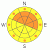
THREAT #2 |

|
| WHERE |
PROBABILITY |
SIZE |
TREND |
|
|
|
|
| |
|
|
Over the next
72 hours.
|
|
|
While the winds have been well behaved, there is a surplus of nice light density snow that will be easily formed into windslabs. Windslabs will be few and far between on Friday, limited to big open slopes above treeline. But, with all the new snow it won't take long for even moderate winds to form fresh sensitive wind slabs. I expect winds to pick up early Saturday morning before the next storm pulse arrives, so, be heads up for signs of windslabs: fat, rounded & pillow like formations on the downwind sides of ridges. If you observe shooting cracks or see snow being actively loaded onto a slope, it’s definitely time to seek more conservative terrain. Often times you can feel the snow changing under the machine too; windslabs feel stiffer than loose snow. If you start to feel that change while climbing, turn out and seek more protected treed terrain where wind slabs won't be as much of an issue. |
|
|
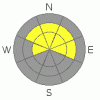
THREAT #3 |

|
| WHERE |
PROBABILITY |
SIZE |
TREND |
|
|
|
|
| |
|
|
Over the next
72 hours.
|
|
|
While the new snow preoccupies our thoughts, there is an active weak layer down 2.5' below our machines. This is the old surface hoar formed early in January. This weakness exists on high elevation W, NW, N, NE & E facing slopes. Our testing shows that this layer is quite hard to trigger, but once triggered it does fail clean & fast. Avalanches failing in the surface hoar would be quite large & destructive. What exactly is a hard trigger? Well we can exert extra force on the snowpack a couple of ways; by jumping off cornices, wallowing around on our feet trying to free a stuck machine high on a slope, breaking off a big piece of cornice that lands on a slope, or by putting multiple riders on a slope all at the same time. |
|
|
MOUNTAIN WEATHER |

|
We're officially back in the good graces of the storm track. You might get a glimpse or two of the sun today while you're out riding today. Enjoy it, because you won't see it tomorrow. The next pulse sweeps over the Skyline early Saturday morning lingering throughout the day and into the evening. Another foot of new snow is expected out of this system. The meat of the storm moves east Sunday but there is potential for 3" - 7" of new snow out of one last organized burst of storm on Sunday. The holiday Monday will be sunny & deep on the Skyline. Temperatures will remain cool which will help to preserve our powder feast. As we move into the workweek there is potential for another large organized storm system to affect our area. |
|
|
GENERAL ANNOUNCEMENTS |
See or trigger an avalanche? I'd like to hear about it! You can reach me on my cell phone: 801-824-0305 or shoot me an email: grant (at) utahavalanchecenter (dot) org Observers may choose to remain anonymous if they wish.
Click here for a refresher on the Avalanche Danger Scale.
Click here for a review on the Danger Rose.
This forecast will be updated by 7:00am Friday February 25th. |
|
|
This information does not apply to developed ski areas or highways where avalanche control is normally done. This advisory is from the U.S.D.A. Forest Service, which is solely responsible for its content. This advisory describes general avalanche conditions and local variations always occur. |
|
This advisory provided by the USDA Forest Service, in partnership with:
The Friends of the Utah Avalanche Center, Utah Division of State Parks and Recreation, Utah Division of Emergency Management, Salt Lake County, Salt Lake Unified Fire Authority and the friends of the La Sal Avalanche Center. See our Sponsors Page for a complete list. |
