SPECIAL ANNOUNCEMENT |
 |
Our fourth annual Avy Ride, a fundraiser benefitting avalanche outreach and education specifically for snowmobilers, will be held Saturday Feb. 26th. We’re still working some elements out on our website, but you can get more details by clicking here. |
|
|
BOTTOM LINE
Danger by aspect and elevation on slopes approaching 35° or steeper.
(click HERE for tomorrow's danger rating)
|

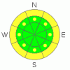
Danger Rose Tutorial
|
On the shady slopes, those that face N, NE & E there is a Level 2 (Moderate) avalanche danger due to a persistent slab. Avoid riding near rocks, cliff bands, steep slopes & convex rollers on slopes that face the shady side of the compass.
As we move into very warm temperatures this weekend there will be a Level 2 (Moderate) avalanche danger associated with wet avalanche activity on low & mid elevation slopes on all aspects. Getting off the slopes early before they get too hot & unsupportable will allow you to avoid this hazard. |
|
|
CURRENT CONDITIONS |

|
With only 11" of snowfall in the last month, finding good riding conditions is a bit tricky. There are still a few pockets of soft snow on shady mid elevation slopes in the trees. Everything else is pretty firm. While it's disappointing if you're a powder rider, the current conditions are excellent for climbing. It's 12° this morning under clear skies with light winds out of the West. |
|
|
RECENT ACTIVITY |

|
No recent activity reported or observed. |
|
|
THREAT #1 |

|
| WHERE |
PROBABILITY |
SIZE |
TREND |

|
|
|
|
| |
|
|
Over the next
72 hours.
|
|
|
On January 11th it rained to ridgetop on the Skyline which created a rain crust of varying thickness across the forecast area. Since then, we've received 11" of settled snow. The recent cold temperatures have significantly weakened the rain crust, and it is reactive in our tests. This structure is most prevalent on slopes at and above treeline that face N, NE & E. While an 11" deep slab isn't a terribly big avalanche, this is behaving like a hard slab. This means that it has the potential to break above you & break out wider than you might expect. You're most likely to trigger one of these avalanches in steep terrain, near rock outcroppings or cliff bands & in places with a convex roll over. |
|
|
THREAT #2 |

|
| WHERE |
PROBABILITY |
SIZE |
TREND |
|
|
|
|
| |
|
|
Over the next
24
hours.
|
|
|
As we move into the weekend we're looking at some very warm temperatures. The sun is high in the sky now & has a strong effect on the snowpack. Watch for wet avalanches at & below treeline on both Saturday & Sunday initially on east aspects, moving to south, west and possibly even north facing slopes late in the afternoon. Rollerballs (Pinwheels) and the feeling of the machine sinking deeper into the snowpack are signs that it's too warm to be on a slope. |
|
|
MOUNTAIN WEATHER |

|
Things begin to heat up today under clear skies as the temperatures top out near 30°. Temps cool down to the teens overnight before making the big push towards 40° tomorrow. Sunday is another scorcher with 10,000' temps reaching towards the low 40's. This trend continues into the workweek. There is a potential for a change in the weather pattern mid week but details are a bit sketchy at this time. Let's hope it brings us some snow! |
|
|
GENERAL ANNOUNCEMENTS |
See or trigger an avalanche? I'd like to hear about it! You can reach me on my cell phone: 801-824-0305 or shoot me an email: grant (at) utahavalanchecenter (dot) org Observers may choose to remain anonymous if they wish.
Click here for a refresher on the Avalanche Danger Scale.
Click here for a review on the Danger Rose.
This forecast will be updated by 7:00am Friday February 18th. |
|
|
This information does not apply to developed ski areas or highways where avalanche control is normally done. This advisory is from the U.S.D.A. Forest Service, which is solely responsible for its content. This advisory describes general avalanche conditions and local variations always occur. |
|
This advisory provided by the USDA Forest Service, in partnership with:
The Friends of the Utah Avalanche Center, Utah Division of State Parks and Recreation, Utah Division of Emergency Management, Salt Lake County, Salt Lake Unified Fire Authority and the friends of the La Sal Avalanche Center. See our Sponsors Page for a complete list. |
