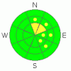
BOTTOM LINE
Danger by aspect and elevation on slopes approaching 35° or steeper.
(click HERE for tomorrow's danger rating)
|

Danger Rose Tutorial
|
This morning the avalanche danger is mostly Level 1 (Low). The exception is high elevation N & NE facing slopes where the crust is thin & weak. These slopes have a Level 2 (Moderate) danger.
As the day progresses the avalanche danger will rise to Level 2 (Moderate) on all slopes as the potential for cornice failure and wet avalanche activity increase with the unseasonably warm temperatures. |
|
|
CURRENT CONDITIONS |

|
If you prefer riding powder then the conditions are pretty dismal. The snow surface is a mixed bag of rain crust and thin stiff wind deposited snow.
But, if climbing is your thing, then the conditions are amazing. There is just enough new snow that you don't need scratchers, and the travel conditions are excellent right now. The snow surface will allow you to get your machine anywhere you please with ease.
You can check out recent observations here. |
|
|
RECENT ACTIVITY |

|
I observed a few cornice failures yesterday, but, they did not trigger any avalanches. No other avalanche activity was reported or observed. |
|
|
THREAT #1 |

|
| WHERE |
PROBABILITY |
SIZE |
TREND |
|
|
|
|
| |
|
|
Over the next
24 hours.
|
|
|
95 % of the terrain on the Skyline feels pretty locked up. The exception is high elevation N, NE & SE aspects. Digging high above S. Lake creek yesterday I found intact surface hoar below a crust that is much thinner and weaker than any other place I observed. Be heads up about the very top of the steepest bowls which will harbor these conditions. Remember that these are the exception; there are plenty of places to go today where you can safely climb to your hearts content. |
|
|
THREAT #2 |

|
| WHERE |
PROBABILITY |
SIZE |
TREND |

|
|
|
|
| |
|
|
Over the next
48 hours.
|
|
|
Massive cornices hang over lee slopes across the Skyline, those that face NE, E & SE. Give these monsters a wide berth as temperatures heat up both today and Saturday. You don't want to be underneath one of these things when it decides to cut loose! |
|
|
THREAT #3 |

|
| WHERE |
PROBABILITY |
SIZE |
TREND |
|
|
|
|
| |
|
|
Over the next
48 hours.
|
|
|
Friday & Saturday will be un-seasonably warm in the mountains. The big question is how will this affect the snowpack structure? Honestly, I'm not sure if the temperatures will reach the threshold for weakening the crusts but one thing is for sure; if you feel the machine start to wallow & break through the crusts, it's time to pull the plug and leave. Why? The crust is what's keeping us out of the surface hoar, once it starts to weaken the potential for persistent slab avalanches increases. These avalanches would average only a foot in depth, but, they have the potential to break far above you and propagate much farther & wider than you'd expect. Keep a close eye on how your machine is interacting with the crusts and you should be good to go. |
|
|
MOUNTAIN WEATHER |

|
It's just before 7 am, and temperatures have already risen to 33 F, even at the Skyline Wx which sits at 9300'. It's going to be a very warm day in the mountains. Highs are expected to hit 40 F, even at our highest elevations today. Tomorrow is more of the same, sunny skies and warm temperatures. Might not be a bad idea to pull the hood off the machine. Clouds stream into the region Sunday bringing more seasonal temperatures and a slight chance of snow, although no significant accumulations are expected. |
|
|
GENERAL ANNOUNCEMENTS |
See or trigger an avalanche? I'd like to hear about it! You can reach me on my cell phone: 8zero1-824-0305 or shoot me an email: grant (at) utahavalanchecenter (dot) org Observers may choose to remain anonymous if they wish.
Click here for a refresher on the Avalanche Danger Scale.
Click here for a review on the Danger Rose.
This forecast will be updated by 7:00 am on Friday February 4th, 2011. |
|
|
This information does not apply to developed ski areas or highways where avalanche control is normally done. This advisory is from the U.S.D.A. Forest Service, which is solely responsible for its content. This advisory describes general avalanche conditions and local variations always occur. |
|
This advisory provided by the USDA Forest Service, in partnership with:
The Friends of the Utah Avalanche Center, Utah Division of State Parks and Recreation, Utah Division of Emergency Management, Salt Lake County, Salt Lake Unified Fire Authority and the friends of the La Sal Avalanche Center. See our Sponsors Page for a complete list. |
