SPECIAL ANNOUNCEMENT |
 |
A SPECIAL AVALANCHE ADVISORY has been issued for the mountains of northern and central Utah, to include the Bear River Range, the western Uintas and the Wasatch Plateau. The avalanche danger will be on the rise through the holiday weekend. Dangerous human triggered avalanches will be likely at the mid and upper elevations. Those without excellent avalanche skills should avoid being on or underneath steep mountain slopes. |
|
|
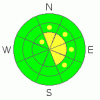
BOTTOM LINE
Danger by aspect and elevation on slopes approaching 35° or steeper.
(click HERE for tomorrow's danger rating)
|
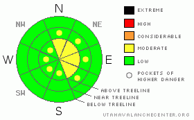
Danger Rose Tutorial
|
This is a time of transition. While the avalanche danger is mostly Level 1 (Low) the danger will quickly rise to Level 2 (Moderate) with an increase in wind speed. Remember, if the winds start blowing, increased avalanche danger will be soon to follow. |
|
|
CURRENT CONDITIONS |

|
It's 24° this morning & winds are light out of the WNW. We received a trace of new snow last night. Cold temperatures have weakened the snow surface to the point where riding conditions remain quite good on shady slopes out of the wind. |
|
|
RECENT ACTIVITY |

|
A few shallow point release avalanches were observed on southerly aspects yesterday, but no significant avalanche activity has been observed or reported. |
|
|
THREAT #1 |

|
| WHERE |
PROBABILITY |
SIZE |
TREND |
|
|
|
|
| |
|
|
Over the next
24
hours.
|
|
|
Our snowpack is transitioning from a beautiful well bonded 'pack to a very weak, sensitive, tricky & dangerous 'pack. Why? Our snow surface is a combination of surface hoar & faceted snow. The few inches of snow we received last weekend capped the weak snow, and now a nasty persistent weak layer is preserved in our snowpack. Right now, it's not much of a concern, but as we begin to add load to the snowpack, it will command our attention.
Winds are forecasted to remain light, and we're not expecting more than an inch or two of snow out of the storm systems passing over the forecast area this weekend. But, if the wind begins to howl, watch out. Any significant amount of wind transported snow (say, 6" or more) will quickly overload the weaknesses in our snowpack. For the time being, this should be a very manageable avalanche hazard. Place slope cuts in the slopes you plan to play on, and keep a close eye on the wind. |
|
|
THREAT #2 |

|
| WHERE |
PROBABILITY |
SIZE |
TREND |

|
|
|
|
| |
|
|
Over the next
24
hours.
|
|
|
Out of the wind, the avalanche danger is currently low. But, low danger doesn't mean no danger. Continue to practice your good backcountry riding habits. Keep your beacon on, & your shovel & probe in your backpack. Remember; one rider on a slope at a time, all other riders should point their machines away from the slope, and keep a close eye on the person actively riding. |
|
|
MOUNTAIN WEATHER |

|
The tail end of storm system that been hammering British Columbia is making its way across Utah. Unfortunately for us, the system is pretty played out and won't be delivering much in the way of precipitation. Expect cloudy skies today with a high near freezing and a trace of new snow. Saturday brings mostly sunny skies with a high near freezing. Sunday will mirror today with mostly cloudy skies, a high of 33° and total daytime snow accumulations of less than an inch. There's potential for a more substantial system to move through our area mid week, but right now the models are conflicted as to the timing & impact of the storm. |
|
|
GENERAL ANNOUNCEMENTS |
See or trigger an avalanche? I'd like to hear about it! You can reach me on my cell phone: 801-824-0305 or shoot me an email: grant (at) utahavalanchecenter (dot) org
Click here for a refresher on the Avalanche Danger Scale.
Click here for a review on the Danger Rose.
This forecast will be updated by 7:00am Friday January 21st. |
|
|
This information does not apply to developed ski areas or highways where avalanche control is normally done. This advisory is from the U.S.D.A. Forest Service, which is solely responsible for its content. This advisory describes general avalanche conditions and local variations always occur. |
|
This advisory provided by the USDA Forest Service, in partnership with:
The Friends of the Utah Avalanche Center, Utah Division of State Parks and Recreation, Utah Division of Emergency Management, Salt Lake County, Salt Lake Unified Fire Authority and the friends of the La Sal Avalanche Center. See our Sponsors Page for a complete list. |
