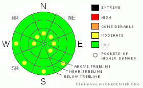
BOTTOM LINE
Danger by aspect and elevation on slopes approaching 35° or steeper.
(click HERE for tomorrow's danger rating)
|
Danger Rose Tutorial
|
A mostly Level 1 (Low) avalanche danger exist with isolated pockets of Level 2 (Moderate) avalanche danger due to isolated wind slabs at upper elevations. Carefully evaluate your route if entering the more extreme terrain as even a small avalanche can have serious consequences.
Pockets of Level 2 (Moderate) avalanche danger exist on low & mid elevation slopes that face W, SW, S & SE. Watch for wet point release avalanches as the sun begins to heat these aspects up Friday afternoon. |
|
|
CURRENT CONDITIONS |

|
Temperatures are in the mid twenties & winds are light across the forecast area. Our Millers Flat snow stake now reads a total of 55" of well settled snow. Excellent riding on settled powder can be found at low and mid elevations. High elevations have been hammered by wind; surface conditions up high are a mix of wind slabs and wind scoured snow. Riding above treeline is marginal at best. |
|
|
RECENT ACTIVITY |

|
A few cornice failures were noted along the Lake Creek ridgeline, but they produced little in the way of avalanches. It's pretty quiet on the Skyline at the moment. |
|
|
THREAT #1 |

|
| WHERE |
PROBABILITY |
SIZE |
TREND |
|
|
|
|
| |
|
|
Over the next
24
hours.
|
|
|
Great visibility & travel conditions allowed us to cover quite a bit of ground yesterday. Numerous tests revealed a well bonded & mostly stable snowpack. There's a catch though; prolonged cold temperatures have weakened the surface of our snowpack creating both near surface facets & surface hoar. Once buried, these layers will be the weak link in our snowpack.
Very stubborn wind slabs exist at upper elevations & while they shouldn't be an issue for most of us, carefully evaluate your route if entering the more extreme terrain to be sure that a small windslab doesn't push you into a precarious position.
It doesn't look like our weekend storm is going to produce much in the way of precipitation, but be aware that any new snow will be falling on a very weak surface. I don't expect significant accumulations out of this storm, but if it does begin to stack up, you can expect loose snow avalanches & sensitive wind slabs in wind exposed terrain. |
|
|
THREAT #2 |

|
| WHERE |
PROBABILITY |
SIZE |
TREND |
|
|
|
|
| |
|
|
Over the next
24 hours.
|
|
|
Temperatures are forecasted to climb above freezing all the way to 10,000' on Friday. Watch for wet point release avalanches on low & mid elevation slopes Friday afternoon. |
|
|
MOUNTAIN WEATHER |

|
Sunny skies & warm temperatures will make Friday a beautiful day in the mountains. Temperatures will cool down as a pacific cold front moves across our area Saturday. Light snow is expected through the weekend, total accumulations are in the 3 - 6" range. The weak storm system dissipates as we enter the work week leaving cooler temperatures in its wake. |
|
|
GENERAL ANNOUNCEMENTS |
See or trigger an avalanche? I'd like to hear about it! You can reach me on my cell phone: 801-824-0305 or shoot me an email: grant (at) utahavalanchecenter (dot) org
This forecast will be updated by 7:00am Friday January 14th.
Click here for a refresher on the Avalanche Danger Scale.
Click here for a review on the Danger Rose. |
|
|
This information does not apply to developed ski areas or highways where avalanche control is normally done. This advisory is from the U.S.D.A. Forest Service, which is solely responsible for its content. This advisory describes general avalanche conditions and local variations always occur. |
|
This advisory provided by the USDA Forest Service, in partnership with:
The Friends of the Utah Avalanche Center, Utah Division of State Parks and Recreation, Utah Division of Emergency Management, Salt Lake County, Salt Lake Unified Fire Authority and the friends of the La Sal Avalanche Center. See our Sponsors Page for a complete list. |
