BOTTOM LINE
Danger by aspect and elevation on slopes approaching 35° or steeper.
(click HERE for tomorrow's danger rating)
|
Danger Rose Tutorial
|
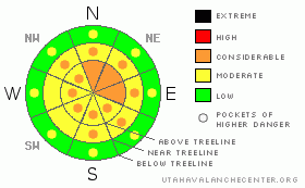
A Level 3 (Considerable) avalanche danger exists at & above treeline. Natural avalanches are still possible & human triggered avalanches are likely on wind exposed slopes greater than 35 degrees. Expert avalanche skills are required in order to carefully manage the current hazard. |
|
|
CURRENT CONDITIONS |

|
Temperatures average a bone chilling -5 across the region this morning and winds are out of the W @ 10 mph. The storm laid down an additional 18" of medium density snow on top of our already deep snowpack. With these conditions low & mid elevation slopes protected from the wind will offer incredible riding today. |
|
|
RECENT ACTIVITY |

|
Visibility was challenging yesterday to say the least, and our observations were limited to low angle slopes in the trees. With all the new snow & wind, I suspect a natural avalanche cycle occurred during the storm in the bigger more exposed terrain. |
|
|
THREAT #1 |

|
| WHERE |
PROBABILITY |
SIZE |
TREND |

|
|
|
|
| |
|
|
Over the next
24 hours.
|
|
|
The storm brought winds out of the SW, W & NW at speeds above threshold for creating dangerous wind slabs. Watch for fresh sensitive slabs from 2 to 4 feet deep above treeline in wind exposed locations.
We need to give the snowpack some extra time to adjust before we jump into the bigger more exposed terrain as the bitterly cold temperatures slow down the 'packs natural settlement/healing process. Getting into the big bowls at this point is a pure roll of the dice, and unfortunately, the odds are not in your favor. The only effective way to deal with the hazard this weekend is to make wise terrain choices. By limiting your riding to protected lower angle slopes and being sure that you are not subject to avalanche danger from above, you can finish 2010 with a safe weekend full of over the hood riding conditions. |
|
|
THREAT #2 |

|
| WHERE |
PROBABILITY |
SIZE |
TREND |

|
|
|
|
| |
|
|
Over the next
24 hours.
|
|
|
The old snow surface is a mixed bag of wind skin, solar crust & settled snow. Watch for soft loose avalanches, even when you're playing below tree line. Be especially heads up in gulley features & creek bottoms where even a small amount of snow can stack up quickly if it starts to move. |
|
|
MOUNTAIN WEATHER |

|
Snow will gradually diminish through the morning as the storm exits to our East. We can expect an additional 2 - 5" before it's all done. The mercury will squeak it's way to 4 today before plummeting to -11 overnight. New Years day dawns crisp & beautiful; clear skies are expected with a high of 10. Sunday looks like another stunning day, with mostly clear skies & a high of 26. A weakening storm system drifts our way Sunday evening, bringing a chance of snow through early next week. |
|
|
GENERAL ANNOUNCEMENTS |
See or trigger an avalanche? I'd like to hear about it! You can reach me on my cell phone: 801-824-0305 or shoot me an email: grant (at) utahavalanchecenter (dot) org Observers may choose to remain anonymous if they wish.
We are teaching a Snowmobile Avalanche Awareness Course the week of January 5th. Click here for details.
Click here for a refresher on the Avalanche Danger Scale.
Click here for a review on the Danger Rose.
This forecast will be updated by 7:00am Friday January 7th. |
|
|
This information does not apply to developed ski areas or highways where avalanche control is normally done. This advisory is from the U.S.D.A. Forest Service, which is solely responsible for its content. This advisory describes general avalanche conditions and local variations always occur. |
|
This advisory provided by the USDA Forest Service, in partnership with:
The Friends of the Utah Avalanche Center, Utah Division of State Parks and Recreation, Utah Division of Emergency Management, Salt Lake County, Salt Lake Unified Fire Authority and the friends of the La Sal Avalanche Center. See our Sponsors Page for a complete list. |
