SPECIAL ANNOUNCEMENT |
 |
This is a special Holiday update of the December 24th Forecast. |
|
|
BOTTOM LINE
Danger by aspect and elevation on slopes approaching 35° or steeper.
(click HERE for tomorrow's danger rating)
|
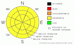
Danger Rose Tutorial
|
A Level 2 (MODERATE) avalanche danger exists at treeline & above on slopes 35 degrees and steeper. The massive storm system left over 3' of new snow, and while the snowpack is settling out rapidly, expert avalanche skills are needed to carefully analyze bigger slopes before committing your life to them.
Watch for wet avalanches on slopes that see the most sun, those that face SE, S, SW & W. Temperatures are expected to rise above freezing all the way to ridgetop & the danger from wet avalanches will increase as the day goes on. |
|
|
CURRENT CONDITIONS |

|
It's 35 degrees under mostly clear & calm skies this morning. The last storm system laid down a little over 3' of fresh snow on the Skyline making for over the hood conditions. |
|
|
RECENT ACTIVITY |

|
The clouds parted for a few hours Thursday afternoon revealing a glimpse of the recent natural avalanche cycle. Large avalanches up to 3' in depth are running on a crust formed by rain early in the storm system. Click here for details. |
|
|
THREAT #1 |

|
| WHERE |
PROBABILITY |
SIZE |
TREND |
|
|
|
|
| |
|
|
Over the next
24
hours.
|
|
|
I expect that most of the instabilities associated with the storm snow have settled out at this point. The big terrain still needs to be approached with a great deal of caution though. Tweak small test slopes on your machine to see how they respond. If the bigger slopes are your goal, work your way up to them slowly, and continue to test the snow as you go. The Extended Column Test would be a great tool to use today. If you don't know how to perform one, consider taking our snowmobile specific avalanche class in early January, details are in the general announcements section. |
|
|
THREAT #2 |

|
| WHERE |
PROBABILITY |
SIZE |
TREND |
|
|
|
|
| |
|
|
Over the next
24
hours.
|
|
|
Numerous small wet avalanches were observed at lower elevations on Thursday. Temps will be on the rise this weekend, and you can expect another round of point release wet avalanches which will creep up in elevation. Watch slopes that see the most sun, those that face S, SE, SW & W, as the new snow will be susceptible to point release wet avalanches. Be especially heads up in gullies and creek bottoms where the snow can pile up quickly & be careful where you park your rig. |
|
|
MOUNTAIN WEATHER |

|
The weather should be beautiful in the mountains today. Getting up high will get you above the inversion and into the sunshine. Christmas day is more of the same, with temps above freezing all the way to 10,000'. A weak storm system moves past us Sunday evening before moderate temperatures and sunny days take hold for the first half of the week. The models have aligned for a more robust cold front to move into our area in the second half of the week. |
|
|
GENERAL ANNOUNCEMENTS |
See or trigger an avalanche? I'd like to hear about it! You can reach me on my cell phone: 801-824-0305
or shoot me an email: grant (at) utahavalanchecenter (dot) org
We are teaching a Snowmobile Avalanche Awareness Course the week of January 5th. Click here for details.
Click here for a refresher on the Avalanche Danger Scale.
Click here for a review on the Danger Rose.
This forecast will be updated by 7:00am Friday December 31st. |
|
|
This information does not apply to developed ski areas or highways where avalanche control is normally done. This advisory is from the U.S.D.A. Forest Service, which is solely responsible for its content. This advisory describes general avalanche conditions and local variations always occur. |
|
This advisory provided by the USDA Forest Service, in partnership with:
The Friends of the Utah Avalanche Center, Utah Division of State Parks and Recreation, Utah Division of Emergency Management, Salt Lake County, Salt Lake Unified Fire Authority and the friends of the La Sal Avalanche Center. See our Sponsors Page for a complete list. |
