BOTTOM LINE
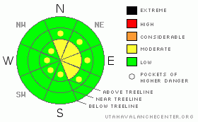
Danger by aspect and elevation on slopes approaching 35° or steeper.
(click HERE for tomorrow's danger rating)
|
Danger Rose Tutorial
|
A Level 2 (Moderate) avalanche danger exists on high elevation lee slopes, those that face N, NE, E & SE. Watch for signs of wind slabs; fat, rounded features that feel hard and supportive. Be suspicious of any slope that appears to be well filled in at upper elevation. |
|
|
CURRENT CONDITIONS |

|
We received 4" of new snow out of this last system, bringing our average snow depth up to 26" at upper elevations. While that depth is over 100% of our average for this time of year, it's still pretty thin out there. Typical early season conditions exist; stumps, logs & rocks are poking out of the snow, or are just barely covered. |
|
|
RECENT ACTIVITY |

|
No recent avalanches observed or reported. |
|
|
THREAT #1 |

|
| WHERE |
PROBABILITY |
SIZE |
TREND |

|
|
|
|
| |
|
|
Over the next
24
hours.
|
|
|
Conditions are ripe for wind slab formation; new snow is available for transport, humidity is high, and the winds are up. Watch for wind slabs on lee aspects, those that face; NE, E & SE. N aspects will have a bit of cross loading too. These slabs were manageable yesterday, averaging 4 - 8" in depth. But, I wouldn't be surprised to find 20" deep slabs in places that see high winds, i.e. near ridge-top.
We can identify windslabs in a few ways; they feel hard and supportive underneath our machines & feet, they can have a sound that is hollow & drum like, and they appear to be fat, rounded formations. Be suspicious of any slope that appears to be well filled in at upper elevation.
Snow depth is just barely at threshold for avalanches at lower & mid elevations. |
|
|
MOUNTAIN WEATHER |

|
Winds will remain blustery today, averaging 20 - 24, gusting as high as 40. We won't see the snow stack up today, total accumulations are expected to be less than 1". More of the same for Sunday, but slightly stronger winds, gusting as high as 45. As we move into the work week skies will clear and temperatures are forecast to rise above freezing. Mid week will bring a cold front our way, just what it will produce remains unclear. |
|
|
GENERAL ANNOUNCEMENTS |
See or trigger an avalanche? I'd like to hear about it. You can reach me on my cell: 801-824-0305, or shoot me an email: grant@utahavalanchecenter.org Observers may choose to remain anonymous if they wish.
Click here for a refresher on the Avalanche Danger Scale.
Click here for a review on the Danger Rose.
This forecast will be updated by 7:00am Friday December 17th. |
|
|
This information does not apply to developed ski areas or highways where avalanche control is normally done. This advisory is from the U.S.D.A. Forest Service, which is solely responsible for its content. This advisory describes general avalanche conditions and local variations always occur. |
|
This advisory provided by the USDA Forest Service, in partnership with:
The Friends of the Utah Avalanche Center, Utah Division of State Parks and Recreation, Utah Division of Emergency Management, Salt Lake County, Salt Lake Unified Fire Authority and the friends of the La Sal Avalanche Center. See our Sponsors Page for a complete list. |
