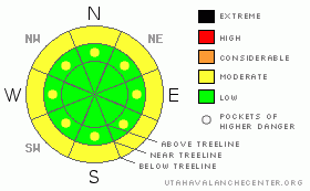
BOTTOM LINE
Danger by aspect and elevation on slopes approaching 35° or steeper.
(click HERE for tomorrow's danger rating)
|

Danger Rose Tutorial
|
The avalanche danger this morning is LOW.
The danger will rise to MODERATE in the afternoon as the sun begins to heat up lower and mid elevations slopes, inducing a possibility of wet slab avalanche activity. Avoid travel on steep sun exposed slopes after lunch time. |
|
|
CURRENT CONDITIONS |

|
Temperatures average 10 F this morning under clear skies. Very light winds are blowing out of the NW.
All aspects and elevations are sporting a nice melt/freeze crust at this point. Early in the day it is supportable & you'll want your scratchers down to keep your machine cool. Later in the day the snow gets a little sloppy as it warms up. |
|
|
RECENT ACTIVITY |

|
A wet slab avalanche hit the road in Hunnington canyon earlier this week. No other activity reported or observed. |
|
|
THREAT #1 |

|
| WHERE |
PROBABILITY |
SIZE |
TREND |

|
|
|
|
| |
|
|
Over the next
48 hours.
|
|
|
Yesterday was pretty chilly, with a high of 21 F at 9,000'. Temperatures remained cool overnight so the melt/freeze crust is nice and supportable on all aspects. (The exception is high elevation due north which has only a thin crust.) You'll want your scratchers on today, as there isn't much soft snow to be found out there at the moment.
Today, temperatures will stay relatively cool at high elevations, but you'll need to watch for signs of warming at mid & low elevations. Things like; roller-balls, pin-wheels, & the machine bogging way down in the wet stuff all indicate that the slope is heating up, and free melt water is beginning to move through the pack. When snow melts, the water has to go somewhere. It trickles down into the snow and loosens up the old bonds, creating wet avalanches. These range from small point releases coming off of rocks, to large full depth avalanches running on the ground.
In short, you’ll want to avoid steep slopes that are being baked in the sun after lunch time. |
|
|
MOUNTAIN WEATHER |

|
You can expect beautiful bluebird skies today if you venture out onto the crusts, with a high near 32 F. Tomorrow will be more of the same, but the high will skyrocket to 48 F at upper elevations.
Clouds begin to roll in Monday, but there is only a slight chance of snow for the rest of the week. |
|
|
GENERAL ANNOUNCEMENTS |
|
|
|
This information does not apply to developed ski areas or highways where avalanche control is normally done. This advisory is from the U.S.D.A. Forest Service, which is solely responsible for its content. This advisory describes general avalanche conditions and local variations always occur. |
|
This advisory provided by the USDA Forest Service, in partnership with:
The Friends of the Utah Avalanche Center, Utah Division of State Parks and Recreation, Utah Division of Emergency Management, Salt Lake County, Salt Lake Unified Fire Authority and the friends of the La Sal Avalanche Center. See our Sponsors Page for a complete list. |


