BOTTOM LINE
Danger by aspect and elevation on slopes approaching 35° or steeper.
(click HERE for tomorrow's danger rating)
|
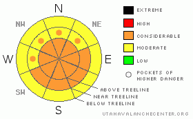
Danger Rose Tutorial
|
Before the storm arrives around noon on Saturday, normal caution is advised. As it starts snowing, the winds will pick up and so too will the avalanche danger. As the storm snow begins to stack up late this afternoon there will be a CONSIDERABLE avalanche danger due to instabilities within the new snow.
Heavy winds out of the north will quickly whip the new snow into sensitive wind slabs, making for a CONSIDERABLE avalanche danger late Saturday afternoon into Sunday.
Additionally, lingering instabilities on our south facing slopes could be overloaded by the wind/storm snow combo, making for a CONSIDERABLE danger due to a persistent slab. |
|
|
CURRENT CONDITIONS |

|
It's 23 F this morning at upper elevations, and winds are light out of the SW. Yesterday we saw a bit of a warm up, but, good settled powder riding can be found on mid and upper elevation north facing slopes this morning, before the storm arrives around lunch time. |
|
|
RECENT ACTIVITY |

|
Earlier this week a few sledders triggered an avalanche near maple canyon on an E - NE facing slope.
A natural soft slab avalanche was observed on a south facing aspect in Rolfson Canyon yesterday.
Other small shallow avalanches were observed in Hunnington Canyon yesterday on mid/upper elevation north through east facing slopes.
You can always jump to the Current Conditions page for the latest updates. |
|
|
THREAT #1 |

|
| WHERE |
PROBABILITY |
SIZE |
TREND |

|
|
|
|
| |
|
|
Over the next
36 hours.
|
|
|
The avalanche danger will ramp up with the arrival of a vigorous storm around lunchtime. After lunch, it will really feel like a storm day; winds will shift to the north and snow will begin to fall in earnest, limiting visibility. There are a variety of old snow surfaces out there right now, the most prevalent being a thin sun-crust. I don't expect the new snow to bond well to the sun-crust at first, thus, the new snow will do quite a bit of sluffing as the afternoon winds down. |
|
|
THREAT #2 |

|
| WHERE |
PROBABILITY |
SIZE |
TREND |
|
|
|
|
| |
|
|
Over the next
36 hours.
|
|
|
We can expect 15" - 24" of new snow by the time we're eating Sunday morning’s breakfast. This should make for some phenomenal riding, but it's not all fun and games. 50 mph ridge top winds out of the north will accompany this storm, and it won't take long to whip all the new snow into a sensitive wind slab. These fresh slabs will pack a punch with depths ranging from one to three feet or more. Remember, most avalanches occur during or just after the storm, so, it's in your best interest to give the big open terrain a miss this afternoon and tomorrow. |
|
|
THREAT #3 |

|
| WHERE |
PROBABILITY |
SIZE |
TREND |

|
|
|
|
| |
|
|
Over the next
36 hours.
|
|
|
An avalanche triggered in the new snow could step down to a lingering instability in the mid pack on our south facing slopes, triggering a bigger avalanche than you bargained for. Don't be lured into a false sense of security on the sunny aspects. |
|
|
MOUNTAIN WEATHER |

|
Pre frontal clouds are scattered across the sky this morning. Our storm should arrive around noon and its game on from there. We can expect 8"- 12" before the sunsets today, and another 7" - 11" overnight. The overnight low will be around 17 F, but will feel more like -1 F with the wind-chill. Sunday brings another 3" - 5" before some clearing in the afternoon. Monday has spectacular blue bird skies in store along with some warming, with high's at upper elevations climbing to around 40 F. Can you take Monday off? If so, get out there and get after it early, it will be worth every minute of missed sleep. The rest of week looks to be sunny & warm. |
|
|
GENERAL ANNOUNCEMENTS |
See or trigger an avalanche? I'd like to hear about it. You can reach me on my cell: (8 zero 1)-8 two 4-0305, or shoot me an email: grant at utahavalanchecenter dot org Observers may choose to remain anonymous if they wish.
This forecast will be updated by 7:00am Saturday March 20th. |
|
|
This information does not apply to developed ski areas or highways where avalanche control is normally done. This advisory is from the U.S.D.A. Forest Service, which is solely responsible for its content. This advisory describes general avalanche conditions and local variations always occur. |
|
This advisory provided by the USDA Forest Service, in partnership with:
The Friends of the Utah Avalanche Center, Utah Division of State Parks and Recreation, Utah Division of Emergency Management, Salt Lake County, Salt Lake Unified Fire Authority and the friends of the La Sal Avalanche Center. See our Sponsors Page for a complete list. |
