BOTTOM LINE
Danger by aspect and elevation on slopes approaching 35° or steeper.
(click HERE for tomorrow's danger rating)
|
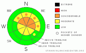
Danger Rose Tutorial
|
1 part snow + 1 part wind makes for a CONSIDERABLE avalanche danger due to wind slabs on slopes that face NW, N, NE & E at both mid and upper elevations. Wind slabs will range in depth from 16" - 30". Follow safe riding protocol: wear your avalanche rescue equipment and only put one person on a slope at a time.
There is a MODERATE danger of triggering a deep slab avalanche failing at the ground on mid & upper elevation slopes that face NW, N, NE, E & SE. |
|
|
CURRENT CONDITIONS |

|
I'm happy to report that riding conditions are currently incredible. The mid-week storm laid down another 16" of light density Utah powder, the stuff we live for. |
|
|
RECENT ACTIVITY |

|
We noted some very active sluffing within the new snow, but, no recent slab activity has been reported or observed. |
|
|
THREAT #1 |

|
| WHERE |
PROBABILITY |
SIZE |
TREND |
|
|
|
|
| |
|
|
Over the next
24
hours.
|
|
|
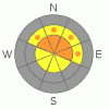
The sun is high in the sky this time of year and it doesn't take long for the snow surface to feel it. Before this last storm a nice solar crust developed almost everywhere aside from North facing slopes, which has made for a very nice bed surface. Watch for sensitive wind slabs at and above tree-line on slopes that face NW, N, NE & E. These soft slabs will likely break at your machine, but, it could pack a wallop, slabs as deep as 2.5' are not out of the question. |
|
|
THREAT #2 |

|
| WHERE |
PROBABILITY |
SIZE |
TREND |
|
|
|
|
| |
|
|
Over the next
24
hours.
|
|
|
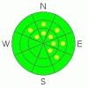
You know it's been an “interesting” season when we're still talking about avalanches at the ground in March. We had a nice cycle of avalanches with the last shot of snow, and I didn't see or hear of any slides that stepped down to the ground. We added another inch of water to the snowpack this week, thus, this is the test of metal for the weak snow near the ground. It's still reactive in testing, which is why I can't quite trust it yet. Be aware that avalanches running in the new snow have the potential to step down and trigger a large avalanche that fails near the ground.
If we see this happen this weekend, then we verify the forecast. If not, I'd be happy to quit worrying this problem child. Time will tell. |
|
|
MOUNTAIN WEATHER |

|
Mostly cloudy skies today with a chance of snow this afternoon as a system crosses to the South of us. There is potential for this one to reach up into our neck of the woods though. Temperatures will climb above freezing, all the way to 10,000 elevations, so, today is the day to get out there and enjoy the fresh stuff.
Sunday/Monday we'll see more snow, likely 6" or so, before a trough of high pressure builds in mid-week. |
|
|
GENERAL ANNOUNCEMENTS |
|
|
|
This information does not apply to developed ski areas or highways where avalanche control is normally done. This advisory is from the U.S.D.A. Forest Service, which is solely responsible for its content. This advisory describes general avalanche conditions and local variations always occur. |
|
This advisory provided by the USDA Forest Service, in partnership with:
The Friends of the Utah Avalanche Center, Utah Division of State Parks and Recreation, Utah Division of Emergency Management, Salt Lake County, Salt Lake Unified Fire Authority and the friends of the La Sal Avalanche Center. See our Sponsors Page for a complete list. |

