BOTTOM LINE
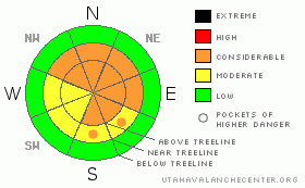
Danger by aspect and elevation on slopes approaching 35° or steeper.
(click HERE for tomorrow's danger rating)
|
Danger Rose Tutorial
|
The avalanche danger is CONSIDERABLE on all aspects at both mid and upper elevations with the exception of W & SW which have a MODERATE danger. Last weekend's storm snow is bonding poorly with the old snow, and rider triggered avalanches are probable.
There is a MODERATE danger with regard to deep slab avalanches failing at the ground. |
|
|
CURRENT CONDITIONS |

|
It's been the best riding we've had all year. 18 to 24 inches of snow was deposited on the Skyline from the recent cycle of storms. At this point, open slopes are wind damaged and slopes that see more sun have a slight melt freeze crust. However, the riding is still excellent in the more sheltered locations.
Temperatures at 10,000' are 15 F this morning at 5 am, 9,000' temps are warmer, right around 25 F. Winds are light out of the South. |
|
|
RECENT ACTIVITY |

|
The new snow isn't all fun and games. There has been wide spread avalanche activity on N, NE & E facing slopes. Soft slabs failing on the new/old snow interface have caught more than one person by surprise.
A sledder was washed down a north facing slope on Tuesday. Details are a bit sketchy, but it sounds like the group was moving from the top of Rolfson, down into the south fork of Lake Canyon. The first rider went down the slope with out incident. The second rider wasn't so lucky; as he entered the slope he triggered a slab avalanche, about 100' wide, 18" deep. It washed him to the bottom of the slope, where he thankfully came out on top. Sounds like the sled is a little mangled. I’ll update the current conditions section as more details become available.
Yesterday, riders reported an avalanche on a North facing slope in Jordan Canyon. A similar avalanche was reported from Staker Canyon. |
|
|
THREAT #1 |

|
| WHERE |
PROBABILITY |
SIZE |
TREND |

|
|
|
|
| |
|
|
Over the next
24
hours.
|
|
|
I'm sure this isn't news to anyone, but, this has been an inconsistent winter with regard to storms. Between storms the top few inches of the snowpack gets absolutely worked. These few inches heat up during the day and then cool way down during the night. This process produces facets, and there was about an inch of nasty little faceted grains on top of the snowpack when last weekends storms rolled through.
There was not much bonding between the new snow and the old snow, and that is why thing have been so touchy as of late. This interface is still pretty weak. The tricky part is that in some places the bond is very weak, while in other places it's stronger. It's entirely slope dependent.
Those with some basic avalanche skills will rely on a quick hand shear test to determine the strength of the bond. Those without should avoid N, NE & E facing slopes approaching 35 degrees in steepness at both mid and upper elevations. |
|
|
THREAT #2 |

|
| WHERE |
PROBABILITY |
SIZE |
TREND |
|
|
|
|
| |
|
|
Over the next
24
hours.
|
|
|
We've had winds out of the NW, SW and now due S. There are still a few tired old wind slabs lurking out there. Wind damaged snow is evident everywhere on the Skyline. Avoid slopes where you can see waves in the snow as well as slopes where the snow feels stiff below your machine. These hard slabs will not me manageable. They have the propensity to break above you, and if this happens, you're likely to go for a ride you don't want to take. |
|
|
THREAT #3 |

|
| WHERE |
PROBABILITY |
SIZE |
TREND |

|
|
|
|
| |
|
|
Over the next
24
hours.
|
|
|
Out of all the recent avalanches I've seen, none of them have stepped down to the ground, which is a very good thing. But, I don't think we're out of the woods yet. The weak snow at the ground is still reactive to testing. Be aware, if you trigger one of the fresher slabs, it could step down and trigger the big one, which would be a large, destructive and nasty avalanche. |
|
|
MOUNTAIN WEATHER |

|
We'll see scattered snow showers today that won't really add up to anything. Temperatures will warm to the mid thirties, even at upper elevations. Tonight and tomorrow are more of the same. Unfortunately, this storm won't be much of a producer for us. Look for clearing early next week before a chance for more snow mid-week. |
|
|
GENERAL ANNOUNCEMENTS |
|
|
|
This information does not apply to developed ski areas or highways where avalanche control is normally done. This advisory is from the U.S.D.A. Forest Service, which is solely responsible for its content. This advisory describes general avalanche conditions and local variations always occur. |
|
This advisory provided by the USDA Forest Service, in partnership with:
The Friends of the Utah Avalanche Center, Utah Division of State Parks and Recreation, Utah Division of Emergency Management, Salt Lake County, Salt Lake Unified Fire Authority and the friends of the La Sal Avalanche Center. See our Sponsors Page for a complete list. |

