AVALANCHE WARNING »
Dangerous avalanche conditions are occuring or are imminent.
Backcountry travel in avalanche terrain is not recommended.
|
 |
Notice: THIS AVALANCHE WARNING IS FOR THE MOUNTAINS OF CENTRAL UTAH. HEAVY SNOWFALL TODAY WILL CONTINUE TO INCREASE THE AVALANCHE DANGER. THE PREEXISTING WEAK SNOW PACK STRUCTURE WILL BE OVERLOADED BY THE NEW SNOW AND LARGE DANGEROUS AVALANCHES MAY OCCUR NATURALLY OR COULD LIKELY BE HUMAN TRIGGERED. PEOPLE ARE URGED TO STAY OUT OF AVALANCHE TERRAIN TODAY. |
|
|
SPECIAL ANNOUNCEMENT |
 |
This advisory will receive a more complete update later this morning (Sunday). |
|
|
BOTTOM LINE
Danger by aspect and elevation on slopes approaching 35° or steeper.
(click HERE for tomorrow's danger rating)
|
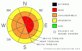
Danger Rose Tutorial
|
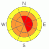
The avalanche hazard is CONSIDERABLE on all aspects at both mid and upper elevations today. Heavy snowfall will overload our weak pre-existing snowpack this afternoon. Natural avalanches are possible. Dangerous human triggered deep slab avalanches are probable. Avalanche hazard will increase to HIGH this afternoon with continued snowfall.
Avoid travel in avalanche terrain today. If you're going to get out, play in the meadows well away from open slopes, & avoid slopes 35 degrees and steeper. |
|
|
CURRENT CONDITIONS |

|
The storm we've been waiting for all season has finally arrived. We received about 6" of snow overnight, and we're looking to pick up as much as a foot of snow today! At 5:00 AM winds are light out of the SW & temperatures are in the mid teens.
Recent observations always available here. |
|
|
RECENT ACTIVITY |

|
No recent activity reported or observed. |
|
|
THREAT #1 |

|
| WHERE |
PROBABILITY |
SIZE |
TREND |
|
|
|
|
| |
|
|
Over the next
24
hours.
|
|
|
We received 6" of new snow overnight, and the hammer will come down today, as we're expecting as much as a foot or two of damp new snow before the sun-sets on the Skyline this evening. Sluffing will be the norm in sheltered locations on all aspects at both mid & upper elevations this morning before the total snowfall has a chance to expose our weaknesses deeper in the pack. |
|
|
THREAT #2 |

|
| WHERE |
PROBABILITY |
SIZE |
TREND |
|
|
|
|
| |
|
|
Over the next
24
hours.
|
|
|
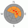
This storm is packing more than enough wallop to overload our weak snowpack structure. As snow totals approach a foot this afternoon, our deep slab avalanche problem will re-awaken. Large natural avalanches are possible today on NW, N, NE, E & SE facing slopes at both mid and upper elevations. Large human triggered avalanches failing at the ground are expected this afternoon. Triggering a deep, un-survivable hard slab avalanche is more likely this weekend than it has been all year.
Avoid travel in avalanche terrain today. If you're going to get out, play in the meadows well away from open slopes, & avoid slopes 35 degrees and steeper.
Wives, do you know where your husbands are riding? Today could be a good day to keep 'em home. |
|
|
THREAT #3 |

|
| WHERE |
PROBABILITY |
SIZE |
TREND |

|
|
|
|
| |
|
|
Over the next
24
hours.
|
|
|
Winds have been well behaved overnight and are expected to remain that way today. However, watch for signs of changing conditions. With all this new snow, it won't take much wind to create fresh sensitive wind slabs on upper and mid elevation slopes facing NW, N, NE, E, SE & S. |
|
|
MOUNTAIN WEATHER |

|
Better late than never, right? We're in the middle of a pretty significant storm that's stalled out over Central Utah. Today's snow totals could reach as high as 2 feet. Expect temperatures to rise to the upper twenties around noon before falling back into the mid teens for the remainder of the day. Snow will continue overnight and through the day Sunday. The storm system should slide east after the weekend, we can expect clearing Monday with a possible blue bird day on Tuesday. |
|
|
GENERAL ANNOUNCEMENTS |
|
|
|
This information does not apply to developed ski areas or highways where avalanche control is normally done. This advisory is from the U.S.D.A. Forest Service, which is solely responsible for its content. This advisory describes general avalanche conditions and local variations always occur. |
|
This advisory provided by the USDA Forest Service, in partnership with:
The Friends of the Utah Avalanche Center, Utah Division of State Parks and Recreation, Utah Division of Emergency Management, Salt Lake County, Salt Lake Unified Fire Authority and the friends of the La Sal Avalanche Center. See our Sponsors Page for a complete list. |

