SPECIAL ANNOUNCEMENT |
 |
Come join forecasters from the UAC along with the talented athletes from Boondockers for our second annual Essential Avy and Riding Skills Workshop. Click here for more details. |
|
|
BOTTOM LINE
Danger by aspect and elevation on slopes approaching 35° or steeper.
(click HERE for tomorrow's danger rating)
|

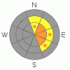
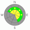
Danger Rose Tutorial
|
The avalanche hazard is CONSIDERABLE. Sensitive wind slabs from 6 - 12 inches in depth exist on NW, N, NE, E & SE facing slopes at high and mid elevations. A MODERATE hazard exists for the potential to trigger a deep hard slab avalanche in specific locations; steep rocky slopes that have not previously avalanched this year. Be alert for changing conditions today as winds pick up out of the NW.
|
|
|
CURRENT CONDITIONS |

|
A storm brushed the Skyline midweek leaving about 6" of new snow. On lee aspects that snow has blown in the old tracks, and the riding conditions are quite good.
Its 21 degrees this morning at the top of Fairview Canyon. Light winds are blowing out of the W-SW at 5 mph, gusting to 15 mph.
Check HERE for recent observations.
|
|
|
RECENT ACTIVITY |

|
No new activity reported or observed. |
|
|
THREAT #1 |

|
| WHERE |
PROBABILITY |
SIZE |
TREND |
|
|
|
|
| |
|
|
Over the next
24
hours.
|
|
|
The Wednesday/Thursday system laid down 6" of storm snow. Along with the snow came the wind, blowing out of the west - northwest as well as west - southwest. This wind helped to fill in the old tracks on the lee aspects, but, it's also created some fresh wind slabs.
This problem will be most prevalent on open slopes near ridge top, but, watch for it at tree-line too. This should be a manageable problem. Slabs will break out at or near your machine, and will be 6" - 12" in depth. Remember that even a small slab can be dangerous if it pushes us into trees, over a rock band or into a gulley.
Winds are expected out of the NW today with gusts near 45 mph. Stay alert for changing conditions and remember as the wind picks up, so to does the avalanche hazard.
|
|
|
THREAT #2 |

|
| WHERE |
PROBABILITY |
SIZE |
TREND |
|
|
|
|
| |
|
|
Over the next
24
hours.
|
|
|
This is an unusual winter. Unusual winters create unusual snowpacks & unusual snowpacks create unusual avalanches. It's getting harder and harder to trigger the deep slab, which is a good thing, but, the potential to trigger one still exists out there. Here's where you'll find it; steep, rocky slopes which have not previously avalanched.
It's been over a week since I've seen any deep slab activity, but, we need to think about it because this is an un-manageable avalanche hazard. If we trigger a slide at the ground the entire season's snowpack will be taken out in big nasty blocks. This is the type of avalanche that can catch us off guard, because only 1 in 10, perhaps only 1 in 20 slopes still have the capacity to avalanche at the ground. While the odds are in your favor, be sure you carefully evaluate a slope before you roll the dice and commit to a high mark with your life as your bet.
|
|
|
MOUNTAIN WEATHER |

|
We should see 2 - 3" of new snow today accompanied by strong winds out of the NW. Daytime temperatures will stay steady around 20 F today, with temperatures in the single digits overnight. Snow will taper off overnight, although we should have overcast skies all weekend. Mon & Tues are more of the same, but the models conflict on what happens next. It doesn't look like anything too robust is in store for us, but, it does look like unstable weather which has the potential to bring more snow. Cross your fingers and toes....
|
|
|
GENERAL ANNOUNCEMENTS |
|
|
|
This information does not apply to developed ski areas or highways where avalanche control is normally done. This advisory is from the U.S.D.A. Forest Service, which is solely responsible for its content. This advisory describes general avalanche conditions and local variations always occur. |
|
This advisory provided by the USDA Forest Service, in partnership with:
The Friends of the Utah Avalanche Center, Utah Division of State Parks and Recreation, Utah Division of Emergency Management, Salt Lake County, Salt Lake Unified Fire Authority and the friends of the La Sal Avalanche Center. See our Sponsors Page for a complete list. |

