SPECIAL ANNOUNCEMENT |
 |
Special Avalanche Advisory
A Special Avalanche Advisory continues for all the mountains of Utah today. Large avalanches can still be triggered by people on slopes approaching 35 degrees. These avalanches are responsible for two fatalities this week. A very persistent weak snowpack will remain unstable for some time to come. People should continue to avoid steep avalanche terrain this weekend. |
|
|
BOTTOM LINE
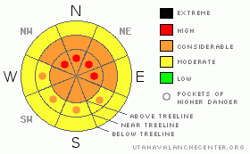
Danger by aspect and elevation on slopes approaching 35° or steeper.
(click HERE for tomorrow's danger rating)
|
Danger Rose Tutorial
|
The avalanche hazard is CONSIDERABLE on high and mid elevation slopes in the shade; those that face NW, N, NE, E & SE. Pockets of HIGH danger exist on these same slopes. Be especially weary of steep rocky slopes. Remember that most avalanche accidents occur when the danger is considerable. Show some respect for the mountain snowpack and avoid travel on or below these slopes. All other slopes have a MODERATE avalanche danger. |
|
|
CURRENT CONDITIONS |

|
Snow totals from the 5 day system last week are around 24" across the forecast area. The storm snow is not quite as fluffy as it once was, as temperatures have warmed to above freezing temps even near ridge top. Slopes that see more of the shade should retain some nice powder riding but those in the sun are likely cooked at this point. |
|
|
RECENT ACTIVITY |

|
Avalanches have caused 2 fatalities across the state in less than a week. I can think of no better point to illustrate just how tricky our snowpack is right now.
I took an extensive tour of the forecast area this week riding from Millers Flat to Potters Pond. Check the current conditions page for more details. While I did see a few large avalanches, the lack of activity is disturbing. We are at the threshold where there isn't quite enough load for slopes to avalanche naturally, but, the slopes are ultra sensitive to the weight of a rider. These are dangerous times folks. |
|
|
THREAT #1 |

|
| WHERE |
PROBABILITY |
SIZE |
TREND |
|
|
|
|
| |
|
|
Over the next
24
hours.
|
|
|
While the science behind the current hazard is fairly complex, the take home message is actually quite simple:
All the recent storm snow sits on top of an incredibly weak base. Most slopes in the forecast area are just barely hanging in place. The weight of a rider is more than enough to overload the weak and fragile structure, causing large, destructive and un-survivable avalanches.
This structure is especially prominent on our shady slopes, those that face Northwest, North, Northeast, East and even Southeast. These are the same slopes that are holding the best riding right now. We must recognize the sirens song here. (The term "siren song" refers to an appeal that is hard to resist but that, if heeded, will lead to a bad result.) While these slopes do indeed hold a few seconds of powder riding bliss, pursuing the sensation could easily be fatal. We need to recognize that there is a very real avalanche danger present, and avoid riding on or below slopes steeper than 30 degrees.
There will be time this season when we can get after it. This is NOT one of those times. |
|
|
MOUNTAIN WEATHER |

|
We'll see the high pressure & the blue skies associated with it move East today. The warm temps will continue today, before cooling out a bit as we move into the second half of the weekend. As we're drying out our gear this evening it will begin snowing lightly. This light snow will continue through Monday. If the models are correct, there isn't a whole lot of precip associated with this storm, we'd be lucky to get 6 inches in total out of the system.
We'll likely see a few more weak disturbances move through the area next week, but nothing significant is on tap. |
|
|
GENERAL ANNOUNCEMENTS |
|
|
|
This information does not apply to developed ski areas or highways where avalanche control is normally done. This advisory is from the U.S.D.A. Forest Service, which is solely responsible for its content. This advisory describes general avalanche conditions and local variations always occur. |
|
This advisory provided by the USDA Forest Service, in partnership with:
The Friends of the Utah Avalanche Center, Utah Division of State Parks and Recreation, Utah Division of Emergency Management, Salt Lake County, Salt Lake Unified Fire Authority and the friends of the La Sal Avalanche Center. See our Sponsors Page for a complete list. |

