SPECIAL ANNOUNCEMENT |
 |
Huge thank you to Glen & the folks at Big Pine Sports in Fairview. In partnership with Arctic Cat, Glen donated a brand new M8 to the avalanche center. Without this machine, this forecast would not be possible. If you value this forecast, thank Glen the next time you see him! |
|
|
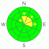
BOTTOM LINE
Danger by aspect and elevation on slopes approaching 35° or steeper.
(click HERE for tomorrow's danger rating)
|

Danger Rose Tutorial
|
The avalanche danger is MODERATE on high elevation slopes that see shade most of the day, those that face N, NE & E. Be particularly weary of steep slopes where strong snow keeps you above ground when you get off the machine. These are the slopes that are harboring a slab. All other slopes have a LOW avalanche danger. Stay alert for changing conditions, as soon as it starts snowing the avalanche danger will quickly rise. |
|
|
CURRENT CONDITIONS |

|
It's a little depressing out there right now. The snow surface is a mixed bag of different crusts. Rain crusts dominate the shady aspects while robust melt/freeze crusts cap the sunny slopes. Underneath the crusts the snow is loose and sugary. Stepping off the machine, a rider often sinks right to the ground. Most of the energy in our snow has been lost through the faceting process. In short, the pack is incredibly weak. |
|
|
RECENT ACTIVITY |

|
No recent activity reported or observed. |
|
|
THREAT #1 |

|
| WHERE |
PROBABILITY |
SIZE |
TREND |
|
|
|
|
| |
|
|
Over the next
24
hours.
|
|
|
The pack is incredibly weak. At the moment, faceting has taken most, but not all of the energy out of the slab. The special thing about snow is that it's different everywhere, what we call spatial variability. While it may only be one in five slopes that has a slab, it takes expert level assessment to decide which slopes are good to go. Tweak nearby test slopes before committing to a hill climb. Jump off the machine and bang out a quick compression or extended column test. If you don't know how, consider taking an avalanche class. You don't want to bet your life on a slope and be wrong.
Steep, rocky slopes in the shade (those that face N, NE & E) are those that are more likely to harbor a slab. In most places you'll sink right to the ground when you get off your machine. If you find a spot that's supporting you above the ground, beware, you've found a slope with a slab. There are a myriad of weak layers underneath that slab that could fail and cause an avalanche. |
|
|
MOUNTAIN WEATHER |

|
This is where is starts to get exciting. High pressure will remain in place today before a small system moves through on Sunday. Monday we enter into a week long series of moist pacific storms that look particularly potent for Southern Utah. The national weather service is calling for significant precip out of these storms. While this is great news, the new snow is going to set off a wide spread & destructive natural avalanche cycle. As soon as it starts snowing, the avalanche hazard will quickly rise. Be alert for changing conditions, especially on Sunday. |
|
|
GENERAL ANNOUNCEMENTS |
See or trigger an avalanche? I'd like to hear about it. You can reach me on my mobile: 801-824-0305, or shoot me an email: grant@utahavalanchecenter.org Observers may choose to remain anonymous if they wish.
I will update this forecast by 7am Saturday January 23rd. |
|
|
This information does not apply to developed ski areas or highways where avalanche control is normally done. This advisory is from the U.S.D.A. Forest Service, which is solely responsible for its content. This advisory describes general avalanche conditions and local variations always occur. |
|
This advisory provided by the USDA Forest Service, in partnership with:
The Friends of the Utah Avalanche Center, Utah Division of State Parks and Recreation, Utah Division of Emergency Management, Salt Lake County, Salt Lake Unified Fire Authority and the friends of the La Sal Avalanche Center. See our Sponsors Page for a complete list. |
