BOTTOM LINE
Danger by aspect and elevation on slopes approaching 35° or steeper.
(click HERE for tomorrow's danger rating)
|
Danger Rose Tutorial
|
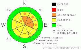
Dangerous Avalanche Conditions exist. High & mid elevation shady aspects (slopes that face North, Northeast and East) are primed for a human triggered avalanche. These slopes have a hazard of CONSIDERABLE. All other high and mid elevation slopes have a hazard of MODERATE. Low elevation slopes didn't have snow on them before last weekend’s storm thus; they have a LOW avalanche hazard. |
|
|
CURRENT CONDITIONS |

|
Like holiday pot luck, there's a little bit of everything out there right now, but, chances are you won't like very much of what's offered. Slopes that spend more time in the sun (South & west) have developed a melt freeze (sun) crust. High elevation east facing slopes in the wind have a bit of a wind skin, while areas that are sheltered from the wind are growing big, beautiful surface hoar. Check here for a quick look at local temperature/wind sites. |
|
|
RECENT ACTIVITY |

|
Slab avalanches continue to release across the range. Improving travel conditions allowed Steve & I to go investigate some of these avalanches. Big "whoophming" sounds heard while traveling indicate that weak layers continue to collapse when weight is added to them. It's a pretty simple recipe really. We've got strong snow sitting on top of very weak snow with a nice bed surface. While natural activity is slowing down, conditions are ripe for a human triggered avalanche. |
|
|
THREAT #1 |

|
| WHERE |
PROBABILITY |
SIZE |
TREND |

|
|
|
|
| |
|
|
Over the next
24
hours.
|
|
|
My favorite Christmas story is the Dickens classic, "A Christmas Carol". There are so many Movie/Book versions that I think we've all seen it. Spending time on our upper elevation slopes is like a visit with the "Ghost of Christmas yet to Come." If you recall this part of the story, the main character is faced with, "Dire visions of the future if he does not learn and act upon what he has witnessed."
We have all the ingredients for slab avalanches in place. Last weekend’s storm snow has settled into a slab. We have a series of crusts near the ground and very weak layers just above that. Add a bit more load to the mix and presto, we have an avalanche.
As humans, we see the settling and bonding of the upper pack as a good thing, as it allows us to travel in the mountains. The avalanche however, feels a heavy load that it can barely hold in place. With nice weather expected this weekend I'm afraid snow starved riders will get into our higher elevation shady slopes. If they do, it's a recipe for disaster. The slab is hanging in place just waiting for rider to overload the snowpack and trigger an avalanche.
Like Scrooge, we need to look to what could happen in the future and change our ways. Getting caught in an avalanche is a very real possibility for folks who push it too hard right now. Officially, it's not even winter yet. There will be days this winter when we can get after it. This however, is not that time. |
|
|
MOUNTAIN WEATHER |

|
The ridge of high pressure currently in place continues to strengthen this weekend. In other words, it's going to be a weekend of clear skies and mild temps. As we move into early next week, we may get a storm cycle as a series of disturbances move into our neck of the woods. At the moment, we're not sure who's going to get the snow, nor do we know how much of it is coming. Don't bet the bank on a big storm. As we head towards Christmas it looks like more high pressure. Certainly not the most exciting forecast for the snow lovers among us. |
|
|
GENERAL ANNOUNCEMENTS |
See or trigger an avalanche? I'd like to hear about it. You can reach me on my mobile: 801-824-0305, or shoot me an email: grant@utahavalanchecenter.org Observers may choose to remain anonymous if they wish.
I will update this forecast by 7am Saturday December 26th. |
|
|
This information does not apply to developed ski areas or highways where avalanche control is normally done. This advisory is from the U.S.D.A. Forest Service, which is solely responsible for its content. This advisory describes general avalanche conditions and local variations always occur. |
|
This advisory provided by the USDA Forest Service, in partnership with:
The Friends of the Utah Avalanche Center, Utah Division of State Parks and Recreation, Utah Division of Emergency Management, Salt Lake County, Salt Lake Unified Fire Authority and the friends of the La Sal Avalanche Center. See our Sponsors Page for a complete list. |
