AVALANCHE WARNING »
Dangerous avalanche conditions are occuring or are imminent.
Backcountry travel in avalanche terrain is not recommended.
|
 |
Notice: |
|
|
SPECIAL ANNOUNCEMENT |
 |
Big Thanks to Rich and Bill for installing our Beacon Basin on top of Skyline Drive yesterday. Now is a great time to tune up the rusty rescue skills & practice with your beacon. |
|
|
BOTTOM LINE
Danger by aspect and elevation on slopes approaching 35° or steeper.
(click HERE for tomorrow's danger rating)
|

Danger Rose Tutorial
|
CONSIDERABLE DANGER for human triggered slides.
A review of the avalanche danger scale is available here. |
|
|
CURRENT CONDITIONS |

|
At the moment the riding is downright bad on the skyline. While the mountains look nice and white from afar, the ugly truth is that the snowpack is thin and very few of the natural hazards (rocks, brush, etc.) are covered up at this time. It would be easy to break your machine out there right now. Travel is best left to roads and very low angle grassy slopes well away from potential avalanche terrain.
It's around 20 degrees at most stations this morning with light wind from the SW. |
|
|
RECENT ACTIVITY |

|
The storm that rolled through earlier this week induced a healthy avalanche cycle on high elevation E - NE facing slopes. It looks like a rider pulled out a size 2.5 avalanche on Skyline Drive after the last storm. The crown was as high as 6' in places; it was an unwelcome surprise for someone. While the natural avalanche cycle has been done for a few days, this will all change as a series of moist storms start rolling in this afternoon. |
|
|
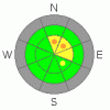
THREAT #1 |

|
| WHERE |
PROBABILITY |
SIZE |
TREND |
|
|
|
|
| |
|
|
Over the next
24
hours.
|
|
|
My grandfather gave me an old .300 Winchester magnum hunting rifle that scares the snot out of me. It's got a hair trigger, and I've got no confidence with it in the field. Our current snowpack scares me for the same reasons. The facets at the ground are large and incredibly weak. Just stepping off the machine produces shooting cracks and the classic "whoopmh" of a failing snowpack. On snow testing produced a score of 0, on a 1- 30 scale. Before the storm, that means we're triggering shallow soft slabs averaging 14" deep.
But, we're about to add a significant shot of new snow to the mix. Our fragile snowpack will not support the weight and it will be that much easier to trigger bigger slabs on North - East facing slopes. |
|
|
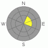
THREAT #3 |

|
| WHERE |
PROBABILITY |
SIZE |
TREND |
|
|
|
|
| |
|
|
Over the next
24
hours.
|
|
|
As I was walking along the ridge of the skyline drive, I found depths of over 9' on the lee (east) side of the ridges. Just 10' down slope, depths are back to 27". That's what makes this so tricky. The shallow snowpack gives us a false sense of security and lures us out to the easily accessible slopes for the first high mark of the season. While these hard slabs are stubborn, when pulled loose, they are incredibly destructive. Potential exists for a 9' crown. Think about that for a second. That's as high as the roof on the enclosed trailer. It will ruin your season before it even starts. |
|
|
MOUNTAIN WEATHER |

|
Temperatures are rising as the approaching system pushes (relatively) warm air into the valleys. The smaller system will move through this afternoon bringing snow showers to the forecast area. The meat of the storm will arrive Sunday morning and will continue through the wee hours of Monday morning. Winds will be steady out of the W - SW during the storm, loading up E - NE facing aspects. We'll see some clearing as we move into the middle of the week. |
|
|
GENERAL ANNOUNCEMENTS |
See or trigger an avalanche? I'd like to hear about it. You can reach me on my cell: 801-824-0305, or shoot me an email: grant@utahavalanchecenter.org Observers may choose to remain anonymous if they wish.
I will update this forecast by 7am next Saturday morning. |
|
|
This information does not apply to developed ski areas or highways where avalanche control is normally done. This advisory is from the U.S.D.A. Forest Service, which is solely responsible for its content. This advisory describes general avalanche conditions and local variations always occur. |
|
This advisory provided by the USDA Forest Service, in partnership with:
The Friends of the Utah Avalanche Center, Utah Division of State Parks and Recreation, Utah Division of Emergency Management, Salt Lake County, Salt Lake Unified Fire Authority and the friends of the La Sal Avalanche Center. See our Sponsors Page for a complete list. |
