SPECIAL ANNOUNCEMENT |
 |
This weekend is the Skyline Shootout, where riders from across North America have descended upon the Manti Skyline. Be sure to park in designated lots, as UDOT is serious about towing anyone parked on the road. Enjoy yourselves and be sure to always travel with your avalanche rescue gear.
This will be the last avalanche forecast of the 2008/2009 season. Big thanks to Glen Zumwalt & all the folks at Big Pine Sports. Also a huge thank you to Steve Cote & Darce trotter for all their help this season! |
|
|
BOTTOM LINE
Danger by aspect and elevation on slopes approaching 35° or steeper.
(click HERE for tomorrow's danger rating)
|
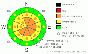
Danger Rose Tutorial
|
The avalanche hazard is generally CONSIDERABLE on the Manti Skyline today. The new snow is failing easily on an old crust interface & strong winds are forming sensitive wind slabs on slopes with an Easterly component. Tweak small test slopes throughout the day & watch for changing conditions. |
|
|
CURRENT CONDITIONS |

|
Thursday night we received 6" of new snow. Friday brought another 4". We picked up another 6" or so last night too. It's no surprise that the riding is currently excellent! It's January in April and no one is complaining. The winds have picked up overnight & temperatures have bottomed out in the teens. |
|
|
RECENT ACTIVITY |

|
Early in the week temperatures reached into the 40's which formed a thin crust on almost all aspects. The new snow is failing easily on this crust. Today looks like the last day of the storm, and I expect all the new snow to continue to behave this way.
No human triggered avalanches reported. |
|
|
THREAT #1 |

|
| WHERE |
PROBABILITY |
SIZE |
TREND |

|
|
|
|
| |
|
|
Over the next
24
hours.
|
|
|
We've picked up 16" of new snow in the last 48 hours. All the new snow is sitting on top of a thin sun crust that formed earlier in the week. The new snow is easily failing in sluff form, running on top of the sun crust. This will be of particular concern two places; 1. In the trees where a bigger sluff could push the machine into the tress, and 2. In big, steep alpine terrain where these sluffs will entrain more snow and can pack enough punch to push you where you don't want to go, or even bury you. |
|
|
THREAT #2 |

|
| WHERE |
PROBABILITY |
SIZE |
TREND |

|
|
|
|
| |
|
|
Over the next
24
hours.
|
|
|
This is the final day of this storm system, and it's going out with a bang. Winds will be steady around 20 mph, gusting to 40 mph. All the new snow will be at the mercy of today's strong winds, which will be forming sensitive wind slabs.
Remember, wind is the architect of avalanches. As the winds increase, so to does the avalanche danger. These winds will be out of the W-NW, so watch E facing slopes for signs of wind loading. Avoid fat looking pillows and stay off slopes that feel stiff or punchy.
While I know that it's the shoot-out, this truly is not the day for multiple people on the slopes. Don’t' forget your most important piece of equipment, your head. |
|
|
MOUNTAIN WEATHER |

|
Currently it's in the mid teens throughout the forecast area, with winds out of the W-NW, averaging 20 mph, gusting to 30 mph. This is the final day of the storm that has been with us since Thursday. It should leave us with another 6" or so of new snow before it pulls out this evening. Today will be blustery, with gusts reaching 40 mph. Sunday looks to be a beautiful blue bird day with a high of 24. Monday, the big warm up starts that will bring highs into the 50's at upper elevations by mid week. There is a slight chance of snow later in the week. |
|
|
GENERAL ANNOUNCEMENTS |
This is the last forecast for the 2008/2009 season.
Big thanks to everyone who made this forecast possible, Glen Zumwalt & the boys at @ Big Pine Motorsports for providing me with a sled every week, Darce Trotter & Steve Cote for their local knowledge, support & help with field days, The Friends of the Utah Avalanche Center for their continued funding support, and all the staff at the Utah Avalanche Center who's dedication saves lives every day. Special thanks to forecasters Craig Gordon & Brett Kobernik for all of their help with the Manti Skyline forecast.
Keep in mind that conditions change dramatically and that information may not be relevant for later in the week.
|
|
|
This information does not apply to developed ski areas or highways where avalanche control is normally done. This advisory is from the U.S.D.A. Forest Service, which is solely responsible for its content. This advisory describes general avalanche conditions and local variations always occur. |
|
This advisory provided by the USDA Forest Service, in partnership with:
The Friends of the Utah Avalanche Center, Utah Division of State Parks and Recreation, Utah Division of Emergency Management, Salt Lake County, Salt Lake Unified Fire Authority and the friends of the La Sal Avalanche Center. See our Sponsors Page for a complete list. |
