BOTTOM LINE
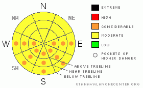
Danger by aspect and elevation on slopes approaching 35° or steeper.
(click HERE for tomorrow's danger rating)
|
Danger Rose Tutorial
|
The avalanche danger this morning is generally MODERATE with regard to avalanches in the new snow. Watch for fat pillows and cross loaded slopes on high elevation E & SE aspects. As the day warms up, the avalanche danger will increase to CONSIDERABLE on all slopes with a southerly component to them. |
|
|
CURRENT CONDITIONS |

|
Riding conditions have improved dramatically! This last week of storms brought a foot and a half of medium density fresh snow to the Skyline. The storms started coming in warm on Sunday then gradually got cooler as we moved through the week giving us a new canvas to go out and play on. The long days and brilliant sunshine have already started working on the new snow though, so get out there and get after it while there's still some spring powder to be played in. |
|
|
RECENT ACTIVITY |

|
On Friday's field day I tried to provoke the snow into moving without much luck. I did however note a few very small point release avalanches in the late afternoon on west facing slopes. This is a sign of things to come, and I expect a natural point release avalanche cycle today as this afternoon’s high temps are to exceed yesterdays. |
|
|
THREAT #1 |

|
| WHERE |
PROBABILITY |
SIZE |
TREND |

|
|
|
|
| |
|
|
Over the next
24
hours.
|
|
|
For the most part, the new snow is behaving pretty well, but it hasn't earned my full trust yet. My snowpit testing tells me that it is possible to trigger an avalanche within the new snow. The northwesterly system that brought all the new snow to us has piled up some wind pillows on SE facing slopes. I'm also weary of high elevation east facing slopes that will be a bit cross-loaded by the week’s winds. Tweak small test slopes before jumping onto the big stuff, and avoid fat looking pillows. |
|
|
THREAT #2 |

|
| WHERE |
PROBABILITY |
SIZE |
TREND |

|
|
|
|
| |
|
|
Over the next
24
hours.
|
|
|
The best riding will be earlier than later today. Watch slopes with a southerly component for signs of daytime heating, such as good snowball making snow. As the slopes become damp, we'll see a natural point release wet avalanche cycle. Best to stay off the solar affected slopes after noon. Keep your avalanche eyes open and watch for the signs of heating, so you know when to say when. |
|
|
MOUNTAIN WEATHER |

|
Today will be bluebird and beautiful on the Skyline, with temperatures rising to a few degrees above freezing at high elevations this afternoon. Tomorrow will start off much the same, though with a little more cloud cover that will turn to snow by Sunday afternoon. The Skyline forecast calls for 6"+ out of this next system. As we move into the week, a series of unorganized disturbances will pass over the forecast area, with a chance of snow through the end of the week. |
|
|
GENERAL ANNOUNCEMENTS |
If you see or trigger an avalanche it would do the community good to report it. Your observations help to save the lives of others. The forecast area is large, and due to funding cuts I only have one field day to spend on the Skyline. This means that I can't possibly see it all. I need you to help me, help you. Please share your observations and experiences:
Shoot me an email: grant@utahavalanchecenter.org and or call me on my cell: 406-370-1337. Thanks!
Due to budget cuts we are only able to produce an advisory that is updated each Saturday morning.
Keep in mind that conditions change dramatically and that information may not be relevant for later in the week.
This forecast will be updated by 7:00am Saturday, April 4th, which will be the last forecast of the season. |
|
|
This information does not apply to developed ski areas or highways where avalanche control is normally done. This advisory is from the U.S.D.A. Forest Service, which is solely responsible for its content. This advisory describes general avalanche conditions and local variations always occur. |
|
This advisory provided by the USDA Forest Service, in partnership with:
The Friends of the Utah Avalanche Center, Utah Division of State Parks and Recreation, Utah Division of Emergency Management, Salt Lake County, Salt Lake Unified Fire Authority and the friends of the La Sal Avalanche Center. See our Sponsors Page for a complete list. |
