BOTTOM LINE
Danger by aspect and elevation on slopes approaching 35° or steeper.
(click HERE for tomorrow's danger rating)
|
Danger Rose Tutorial
|
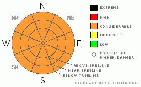
The avalanche hazard is CONSIDERABLE. Wet avalanches are occurring naturally throughout the forecast area on all aspects and elevations. With no refreeze the past two nights, the snowpack is not getting a chance to recover. Rather, it's continuing to loose strength. Cornices are sagging and getting ready to let go too. Riding conditions are wet, sloppy and generally poor. Probably a good day to stay off the snow and tune up your machine for the upcoming shoot-out while praying for colder temps and/or fresh dry snow......
|
|
|
CURRENT CONDITIONS |

|
It's been t-shirt and shorts weather this week. Daytime highs have swelled into the mid fifties even at our highest elevations making for wet, sloppy riding conditions. This is the time of year when you need to be on the snow early with your scratchers down, and then off the snow around lunch when it's getting wet & punchy.
|
|
|
RECENT ACTIVITY |

|
Wet slides galore! It seems everywhere I went this week I saw wet slides ranging from some small point releases to some rather large events that had funneled through gulley features. I noted wet avalanches on nearly all aspects and elevations. While wet slides don't seem to scare us as much as hard slabs, they deserve our respect none the less.
Wet avalanches are a fine blend of overnight low temperatures, day time heating (sun & clouds), & aspect in relation to time of day (generally the East aspects heat up first with morning sun, then South, and then West as the sun heads back towards the pacific).
|
|
|
THREAT #1 |

|
| WHERE |
PROBABILITY |
SIZE |
TREND |

|
|
|
|
| |
|
|
Over the next
24
hours.
|
|
|
The Salt Lake forecasters have been issuing "disclaimers" in their forecasts all week, and I'm going to follow suit here. All the tricks of the black magic known as avalanche forecasting go right out the window when we move from dry to wet snow. We know a LOT more about dry snow than wet.
Fast forward to our current situation. We did NOT get a refreeze last night nor on Thursday night. The snowpack has not gotten a chance to recover over night, and things are very wet, and very sloppy out there at the moment. Free water is running through the snowpack making for generally unstable snow.
Without a refreeze for the last two nights, it's a crap-shoot out there. All aspects and elevations are suspect. The riding is going to be poor, and the machines will likely overheat quickly. If you're sinking into the wet snow when you get off of your machine, then it's time to get off the slopes. The deeper you sink, the bigger the wet avalanches are going to be.
|
|
|
THREAT #2 |

|
| WHERE |
PROBABILITY |
SIZE |
TREND |

|
|
|
|
| |
|
|
Over the next
24
hours.
|
|
|
It's been 48 hours without a re-freeze. This is making our corni tired and grumpy. Give these guys some respect as they battle it out with the warm temps. Right now the heat is winning, making for melting, saggy cornices. You don't want to be underneath/on top of one of these things when they let go!
|
|
|
MOUNTAIN WEATHER |

|
Temperatures will once again swell to the upper mid fifties even at ridge top today with a chance of rain showers and thunderstorms this afternoon. A refreeze is unlikely tonight, further deteriorating our snowpack. The good news is that things begin to change on Sunday. Temperatures will begin to drop to more seasonal norms and we should see snow by Sunday afternoon. Monday is a full on storm day. Potentially, we could see as much as a foot of medium density snow by the time the storm leaves town Monday evening. The rest of the week calls for a chance of snow with low temps in the teens and high temps just below freezing.
|
|
|
GENERAL ANNOUNCEMENTS |
If you see or trigger an avalanche it would do the community good to report it. Your observations help to save the lives of others. The forecast area is large, and due to funding cuts I only have one field day to spend on the Skyline. This means that I can't possibly see it all. I need you to help me, help you. Please share your observations and experiences:
Shoot me an email: grant@utahavalanchecenter.org and or call me on my cell: 406-370-1337. Thanks!
Due to budget cuts we are only able to produce an advisory that is updated each Saturday morning.
Keep in mind that conditions change dramatically and that information may not be relevant for later in the week.
This forecast will be updated by 7:00am Saturday, March 28th. |
|
|
This information does not apply to developed ski areas or highways where avalanche control is normally done. This advisory is from the U.S.D.A. Forest Service, which is solely responsible for its content. This advisory describes general avalanche conditions and local variations always occur. |
|
This advisory provided by the USDA Forest Service, in partnership with:
The Friends of the Utah Avalanche Center, Utah Division of State Parks and Recreation, Utah Division of Emergency Management, Salt Lake County, Salt Lake Unified Fire Authority and the friends of the La Sal Avalanche Center. See our Sponsors Page for a complete list. |
