BOTTOM LINE
Danger by aspect and elevation on slopes approaching 35° or steeper.
(click HERE for tomorrow's danger rating)
|
Danger Rose Tutorial
|
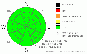
The avalanche danger on the Manti Skyline is currently LOW. Cold temperatures and a lack of precipitation have locked the cornices back up, and for the most part the snowpack is welded in place. Remember, LOW danger does not mean NO danger. Continue to follow good protocol. One person at a time on slopes. ALWAYS ride with your avalanche rescue gear. Don't ride above your buddies. Good habits keep us alive in the mountains. |
|
|
CURRENT CONDITIONS |

|
Conditions haven't changed much since last week. We received a wee bit of fresh from the Wednesday system, a whopping inch and a half of snow. This is sitting on a series of crusts that exist in the upper 7" of the snowpack. Yesterday's storm never really materialized for us. We picked up a lowly inch of snow last night. What's it all mean? It means that the riding quality is on the poor side unless you're really into riding hard pack. On a positive note, it is good exploration snow as the hard pack allows you to hook up with ease & there's just enough fresh to keep the machine cool. |
|
|
RECENT ACTIVITY |

|
No recent activity reported or observed. |
|
|
THREAT #1 |

|
| WHERE |
PROBABILITY |
SIZE |
TREND |

|
|
|
|
| |
|
|
Over the next
24
hours.
|
|
|
Most of the snowpack is locked up by the current lack of precip and chilly night time lows (near 10 F). However, all is not well in the snowpack. Just below the predominant melt freeze crusts some snowpack jihadists have arrived in the form of near surface faceting. Basically, weak snow has developed just below the crust, about 7" from the snow surface. While it's not an issue right now, it could be if we load it up in a hurry. Currently no such storm is forecast for our area, but keep this in mind if we see a big dump.
Don't let the low danger lull you into complacency. Continue to follow good protocol. One rider at a time on the slopes. Keep machines pointed away from slopes while you're watching your buddies. Good habits will save your life. |
|
|
MOUNTAIN WEATHER |

|
Things have cooled down throughout the forecast area with night time lows near 10 F. Daytime highs remained below freezing in the second half of the week as well. The big dumps that were forecasted this week never materialized for us.
The pineapple express that's been getting everyone thinking about quads and dirt bikes has been temporarily replaced by a cooler north-westerly flow that's dropped our temperatures and locked things up for the moment. Sunday night/Monday's storm is coming straight out of British Columbia and it looks pretty menacing for our cousins in the Central Wasatch. Unfortunately, the models don't show it generating much snowfall for the plateau. But, if it decides to come down and visit, you can bet that it will make for some sensitive wind slabs. Be aware for changing conditions.
A warming trend develops again mid week after the Canadian storm clears out. |
|
|
GENERAL ANNOUNCEMENTS |
If you see or trigger an avalanche it would do the community good to report it. Your observations help to save the lives of others. The forecast area is large, and due to funding cuts I only have one field day to spend on the Skyline. This means that I can't possibly see it all. I need you to help me, help you. Please share your observations and experiences:
Shoot me an email: grant@utahavalanchecenter.org and or call me on my cell: 406-370-1337. Thanks!
Due to budget cuts we are only able to produce an advisory that is updated each Saturday morning.
Keep in mind that conditions change dramatically and that information may not be relevant for later in the week.
Want to schedule an avalanche awareness talk? Contact me for details.
This forecast will be updated by 7:00am Saturday, March 14th. |
|
|
This information does not apply to developed ski areas or highways where avalanche control is normally done. This advisory is from the U.S.D.A. Forest Service, which is solely responsible for its content. This advisory describes general avalanche conditions and local variations always occur. |
|
This advisory provided by the USDA Forest Service, in partnership with:
The Friends of the Utah Avalanche Center, Utah Division of State Parks and Recreation, Utah Division of Emergency Management, Salt Lake County, Salt Lake Unified Fire Authority and the friends of the La Sal Avalanche Center. See our Sponsors Page for a complete list. |
